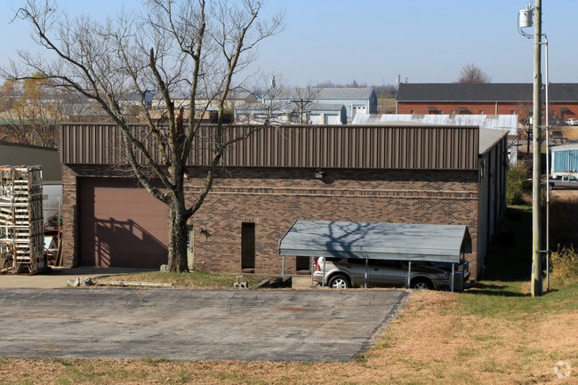
Property Record
133 Macarthur Ct, Nicholasville, KY 40356


Current Lease Availabilities
NEARBY LISTINGS FOR SALE OR LEASE
Property Detail
133 Macarthur Ct
Lexington-Fayette, KY
Bluegrass Ind Park
067-00-00-059.00
133 AND 135
Multipleuses
Jessamine
X
Kentucky
21113C0060D
8
2025
1.01 AC
2025
Jessamine County
060200
Lexington/Fayette
10,500 SF
DEMOGRAPHICS near 133 Macarthur Ct
1 Mile
3 Mile
5 Mile
2024 Total Population
880
30,255
122,262
2029 Population
939
30,295
122,991
Pop Growth 2024-2029
+ 6.70%
+ 0.13%
+ 0.60%
Average Age
44
39
39
2024 Total Households
327
12,105
50,952
HH Growth 2024-2029
+ 7.03%
+ 0.09%
+ 0.43%
Median Household Inc
$92,261
$83,773
$67,737
Avg Household Size
2.60
2.50
2.30
2024 Avg HH Vehicles
2.00
2.00
2.00
Median Home Value
$365,151
$268,407
$249,112
Median Year Built
1982
1996
1985
Nearby Places
Map Layers
Map Styles
 Street
 Aerial
- Restaurants
- Banks
- Shops
- Fitness
- Groceries
PUBLIC TRANSPORTATION
AIRPORT
Blue Grass
DRIVE
WALK
Distance
Blue Grass
23 min
12.7 mi
Freight Ports
Port of Toledo
DRIVE
WALK
Distance
Port of Toledo
349 min
295.9 mi
Nearby Properties
Address
Land Use
TOTAL SIZE
Lot Size
Zoning
Address
Land Use
TOTAL SIZE
Lot Size
Zoning
8,001 SF
32.59 AC
MU-3
Address
Land Use
TOTAL SIZE
Lot Size
Zoning
5,650 SF
22.46 AC
R-3
Address
Land Use
TOTAL SIZE
Lot Size
Zoning
22.10 AC
R-3
Address
Land Use
TOTAL SIZE
Lot Size
Zoning
41,040 SF
14.77 AC
R-4
Address
Land Use
TOTAL SIZE
Lot Size
Zoning
184,756 SF
4.43 AC
MU-3
Address
Land Use
TOTAL SIZE
Lot Size
Zoning
41,132 SF
19 AC
Address
Land Use
TOTAL SIZE
Lot Size
Zoning
6.25 AC
A-U
Address
Land Use
TOTAL SIZE
Lot Size
Zoning
219,320 SF
8.35 AC
R-4
Address
Land Use
TOTAL SIZE
Lot Size
Zoning
4,992 SF
32.12 AC
Address
Land Use
TOTAL SIZE
Lot Size
Zoning
118,794 SF
16.05 AC
B-6P
Address
Land Use
TOTAL SIZE
Lot Size
Zoning
444,063 SF
26.02 AC
Address
Land Use
TOTAL SIZE
Lot Size
Zoning
74,908 SF
15.06 AC
A-U
Address
Land Use
TOTAL SIZE
Lot Size
Zoning
19,536 SF
19.48 AC
R-4
Address
Land Use
TOTAL SIZE
Lot Size
Zoning
Address
Land Use
TOTAL SIZE
Lot Size
Zoning
97,653 SF
6.73 AC
A-U
Address
Land Use
TOTAL SIZE
Lot Size
Zoning
4,142 SF
19.94 AC
Address
Land Use
TOTAL SIZE
Lot Size
Zoning
44,298 SF
11 AC
Address
Land Use
TOTAL SIZE
Lot Size
Zoning
39,277 SF
15 AC
Address
Land Use
TOTAL SIZE
Lot Size
Zoning
13,686 SF
2 AC
Address
Land Use
TOTAL SIZE
Lot Size
Zoning
196,147 SF
20.02 AC
B-3
Address
Land Use
TOTAL SIZE
Lot Size
Zoning
60,990 SF
4.29 AC
Address
Land Use
TOTAL SIZE
Lot Size
Zoning
82,436 SF
4.24 AC
R-4
Address
Land Use
TOTAL SIZE
Lot Size
Zoning
Address
Land Use
TOTAL SIZE
Lot Size
Zoning
52,283 SF
4.89 AC
A-U
Address
Land Use
TOTAL SIZE
Lot Size
Zoning
1,920 SF
99.41 AC
A-U
Address
Land Use
TOTAL SIZE
Lot Size
Zoning
29,690 SF
255 AC
Address
Land Use
TOTAL SIZE
Lot Size
Zoning
52,480 SF
9 AC
Address
Land Use
TOTAL SIZE
Lot Size
Zoning
44,958 SF
MU-3
Address
Land Use
TOTAL SIZE
Lot Size
Zoning
46,722 SF
MU-3
Address
Land Use
TOTAL SIZE
Lot Size
Zoning
200,857 SF
22.84 AC
The World's #1 Commercial Real Estate Marketplace
Connect with us
© 2025 CoStar Group
The information above has been obtained from sources believed reliable. While we do not doubt its accuracy we have not verified it and make no guarantee, warranty or representation about it. It is your responsibility to independently confirm its accuracy and completeness. Any projections, opinions, assumptions, or estimates used are for example only and do not represent the current or future performance of the property. The value of this transaction to you depends on tax and other factors which should be evaluated by your tax, financial, and legal advisors. You and your advisors should conduct a careful, independent investigation of the property to determine to your satisfaction the suitability of the property for your needs.