Property Record
133 Myricks St, Berkley, MA 02779
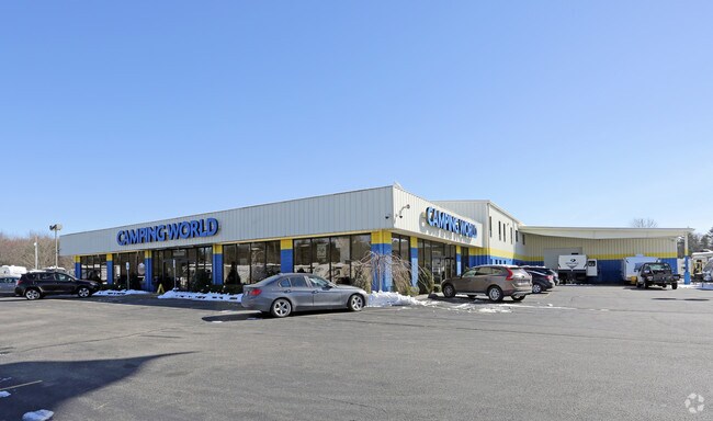

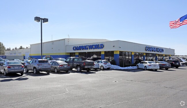
Property Detail
133 Myricks St
BERK-000230-000018-000010
BRISTOL
Vehiclerentalsvehiclesales
Massachusetts
C
1.0
B and X Area of moderate flood hazard, usually the area between the limits of the 100-year and 500-year floods.
9.65 AC
2025
Attleboro/New Bedford
2025
Boston
616100
Providence-Warwick, RI-MA
42,150 SF
NEARBY LISTINGS FOR SALE OR LEASE
-
-
View all Berkley listings for sale on LoopNet.com
DEMOGRAPHICS near 133 Myricks St
1 mile
3 mile
5 mile
2025 Total Population
899
12,322
39,255
2030 Population
910
12,520
40,149
Pop Growth 2025-2030
+ 1.22%
+ 1.61%
+ 2.28%
Average Age
42
42
42
2025 Total Households
303
4,280
14,424
HH Growth 2025-2030
+ 1.32%
+ 1.66%
+ 2.36%
Median Household Inc
$134,642
$120,411
$110,809
Avg Household Size
2.90
2.90
2.70
2025 Avg HH Vehicles
3.00
3.00
2.00
Median Home Value
$584,876
$539,066
$490,535
Median Year Built
1986
1985
1982
Nearby Places
Map Layers
Map Styles
 Street
 Aerial
Layers
 Traffic
 Biking
Places
Listings with unknown addresses are not visible on the map
- Restaurants
- Banks
- Shops
- Fitness
- Groceries
PUBLIC TRANSPORTATION
COMMUTER RAIL
Middleborough/Lakeville (Middleborough/Lakeville Line - Massachusetts Bay Transportation Authority Commuter Rail (Purple Line))
Drive
Walk
Distance
Middleborough/Lakeville (Middleborough/Lakeville Line - Massachusetts Bay Transportation Authority Commuter Rail (Purple Line))
12 min
6.0 mi
AIRPORT
Rhode Island Tf Green International
Drive
Walk
Distance
Rhode Island Tf Green International
54 min
31.9 mi
Freight Ports
Port of New Bedford Harbor
Drive
Walk
Distance
Port of New Bedford Harbor
23 min
16.9 mi
Nearby Properties
Address
Land Use
TOTAL SIZE
Lot Size
Zoning
Address
Land Use
TOTAL SIZE
Lot Size
Zoning
850,008 SF
172.89 AC
INDUST
Address
Land Use
TOTAL SIZE
Lot Size
Zoning
117,752 SF
22.37 AC
Address
Land Use
TOTAL SIZE
Lot Size
Zoning
67,588 SF
18.81 AC
SUBRES
Address
Land Use
TOTAL SIZE
Lot Size
Zoning
137,952 SF
20.99 AC
INDUST
Address
Land Use
TOTAL SIZE
Lot Size
Zoning
103,233 SF
41.66 AC
BIZDIS
Address
Land Use
TOTAL SIZE
Lot Size
Zoning
106,052 SF
50.09 AC
HIWABZ
Address
Land Use
TOTAL SIZE
Lot Size
Zoning
7.50 AC
Address
Land Use
TOTAL SIZE
Lot Size
Zoning
54.97 AC
BIZDIS
Address
Land Use
TOTAL SIZE
Lot Size
Zoning
33,696 SF
11.09 AC
INDUST
Address
Land Use
TOTAL SIZE
Lot Size
Zoning
3,319 SF
266 AC
AIRPRT
Address
Land Use
TOTAL SIZE
Lot Size
Zoning
19,794 SF
144.57 AC
Address
Land Use
TOTAL SIZE
Lot Size
Zoning
68,627 SF
15.35 AC
INDUST
Address
Land Use
TOTAL SIZE
Lot Size
Zoning
231,051 SF
49.85 AC
INDUST
Address
Land Use
TOTAL SIZE
Lot Size
Zoning
100,705 SF
26.25 AC
INDUST
Address
Land Use
TOTAL SIZE
Lot Size
Zoning
76,338 SF
7.04 AC
RURRES
Address
Land Use
TOTAL SIZE
Lot Size
Zoning
12.08 AC
Address
Land Use
TOTAL SIZE
Lot Size
Zoning
43,344 SF
2.77 AC
Address
Land Use
TOTAL SIZE
Lot Size
Zoning
2.70 AC
RURRES
Address
Land Use
TOTAL SIZE
Lot Size
Zoning
100,705 SF
26.25 AC
INDUST
Address
Land Use
TOTAL SIZE
Lot Size
Zoning
680 SF
4.16 AC
C
Address
Land Use
TOTAL SIZE
Lot Size
Zoning
97,384 SF
9.15 AC
INDUST
Address
Land Use
TOTAL SIZE
Lot Size
Zoning
613 AC
Address
Land Use
TOTAL SIZE
Lot Size
Zoning
13,449 SF
4.70 AC
Address
Land Use
TOTAL SIZE
Lot Size
Zoning
22,705 SF
2.58 AC
Address
Land Use
TOTAL SIZE
Lot Size
Zoning
90 AC
G
Address
Land Use
TOTAL SIZE
Lot Size
Zoning
11.93 AC
RURRES
Address
Land Use
TOTAL SIZE
Lot Size
Zoning
97,384 SF
9.15 AC
INDUST
Address
Land Use
TOTAL SIZE
Lot Size
Zoning
8,185 SF
10.01 AC
Address
Land Use
TOTAL SIZE
Lot Size
Zoning
10,200 SF
14.50 AC
RURRES
The World's #1 Commercial Real Estate Marketplace
Connect with us
© 2026 CoStar Group
The information above has been obtained from sources believed reliable. While we do not doubt its accuracy we have not verified it and make no guarantee, warranty or representation about it. It is your responsibility to independently confirm its accuracy and completeness. Any projections, opinions, assumptions, or estimates used are for example only and do not represent the current or future performance of the property. The value of this transaction to you depends on tax and other factors which should be evaluated by your tax, financial, and legal advisors. You and your advisors should conduct a careful, independent investigation of the property to determine to your satisfaction the suitability of the property for your needs.