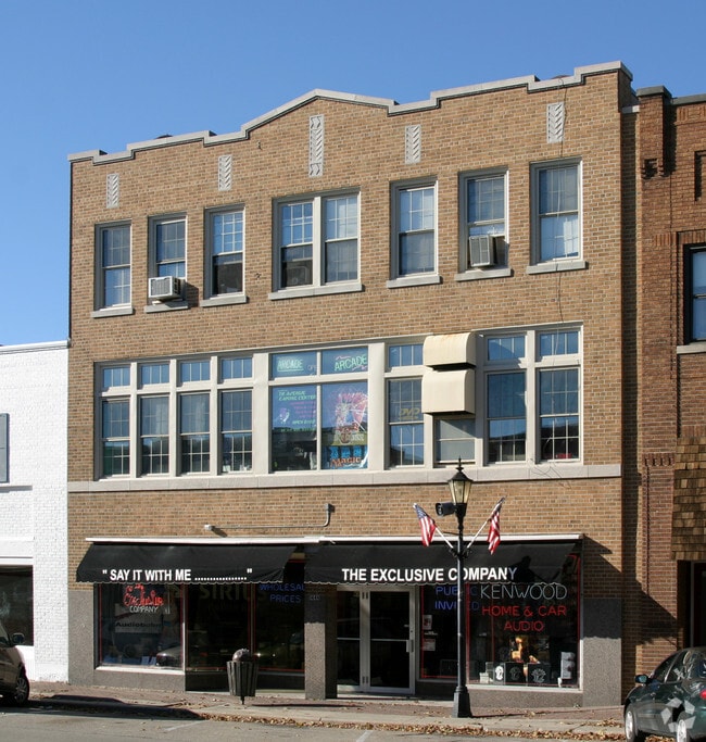
Property Record
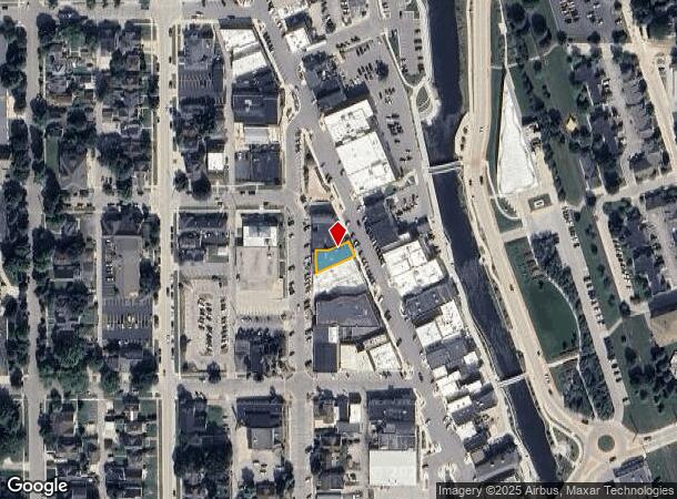
133 N 6Th Ave, West Bend, WI 53095

NEARBY LISTINGS FOR SALE OR LEASE
Property Detail
133 N 6Th Ave
Milwaukee-Waukesha-West Allis, WI
The Original Plat Of The Village
1119-141-0239
ORIGINAL PLAT BLOCK 7 PT OF LOTS 5+6+7 DOC 1221776
Commercialnec
Washington
X
Wisconsin
55131C0166D
5+6+7
2024
0.10 AC
2024
North Washington
420401
Milwaukee/Madison
13,515 SF
DEMOGRAPHICS near 133 N 6Th Ave
1 Mile
3 Mile
5 Mile
2024 Total Population
9,316
37,413
45,450
2029 Population
9,574
38,314
46,632
Pop Growth 2024-2029
+ 2.77%
+ 2.41%
+ 2.60%
Average Age
41
42
43
2024 Total Households
4,153
16,145
19,329
HH Growth 2024-2029
+ 2.91%
+ 2.49%
+ 2.69%
Median Household Inc
$67,153
$69,482
$72,972
Avg Household Size
2.10
2.30
2.30
2024 Avg HH Vehicles
2.00
2.00
2.00
Median Home Value
$189,411
$235,767
$255,727
Median Year Built
1956
1976
1977
Nearby Places
Map Layers
Map Styles
 Street
 Aerial
- Restaurants
- Banks
- Shops
- Fitness
- Groceries
PUBLIC TRANSPORTATION
AIRPORT
General Mitchell International
DRIVE
WALK
Distance
General Mitchell International
62 min
45.0 mi
Freight Ports
Port Milwaukee
DRIVE
WALK
Distance
Port Milwaukee
55 min
41.1 mi
SALE & LEASE HISTORY
LISTING DATE
SALE/LEASE

Apr 19, 2023
For Lease
Nearby Properties
Address
Land Use
TOTAL SIZE
Lot Size
Zoning
Address
Land Use
TOTAL SIZE
Lot Size
Zoning
141,874 SF
116.53 AC
Address
Land Use
TOTAL SIZE
Lot Size
Zoning
5,600 SF
10.11 AC
Address
Land Use
TOTAL SIZE
Lot Size
Zoning
195,055 SF
20.57 AC
Address
Land Use
TOTAL SIZE
Lot Size
Zoning
2.98 AC
Address
Land Use
TOTAL SIZE
Lot Size
Zoning
190,000 SF
64.03 AC
Address
Land Use
TOTAL SIZE
Lot Size
Zoning
141,575 SF
4.44 AC
Address
Land Use
TOTAL SIZE
Lot Size
Zoning
4,140 SF
29.62 AC
Address
Land Use
TOTAL SIZE
Lot Size
Zoning
20.92 AC
Address
Land Use
TOTAL SIZE
Lot Size
Zoning
9.05 AC
Address
Land Use
TOTAL SIZE
Lot Size
Zoning
36,915 SF
11.79 AC
Address
Land Use
TOTAL SIZE
Lot Size
Zoning
139,945 SF
4.95 AC
Address
Land Use
TOTAL SIZE
Lot Size
Zoning
62,974 SF
6.25 AC
Address
Land Use
TOTAL SIZE
Lot Size
Zoning
18.22 AC
Address
Land Use
TOTAL SIZE
Lot Size
Zoning
46.95 AC
Address
Land Use
TOTAL SIZE
Lot Size
Zoning
3,404 SF
49.06 AC
Address
Land Use
TOTAL SIZE
Lot Size
Zoning
30,564 SF
31.65 AC
Address
Land Use
TOTAL SIZE
Lot Size
Zoning
1,620 SF
39.56 AC
Address
Land Use
TOTAL SIZE
Lot Size
Zoning
102,366 SF
9.35 AC
Address
Land Use
TOTAL SIZE
Lot Size
Zoning
50,096 SF
8.91 AC
Address
Land Use
TOTAL SIZE
Lot Size
Zoning
30,046 SF
3.91 AC
Address
Land Use
TOTAL SIZE
Lot Size
Zoning
7.70 AC
Address
Land Use
TOTAL SIZE
Lot Size
Zoning
18,400 SF
10.85 AC
Address
Land Use
TOTAL SIZE
Lot Size
Zoning
65,350 SF
5.92 AC
Address
Land Use
TOTAL SIZE
Lot Size
Zoning
8.29 AC
Address
Land Use
TOTAL SIZE
Lot Size
Zoning
12.67 AC
Address
Land Use
TOTAL SIZE
Lot Size
Zoning
Address
Land Use
TOTAL SIZE
Lot Size
Zoning
27,400 SF
1.83 AC
Address
Land Use
TOTAL SIZE
Lot Size
Zoning
78,372 SF
1.49 AC
Address
Land Use
TOTAL SIZE
Lot Size
Zoning
66,378 SF
10.06 AC
Address
Land Use
TOTAL SIZE
Lot Size
Zoning
56,204 SF
2.29 AC
The World's #1 Commercial Real Estate Marketplace
Connect with us
© 2025 CoStar Group
The information above has been obtained from sources believed reliable. While we do not doubt its accuracy we have not verified it and make no guarantee, warranty or representation about it. It is your responsibility to independently confirm its accuracy and completeness. Any projections, opinions, assumptions, or estimates used are for example only and do not represent the current or future performance of the property. The value of this transaction to you depends on tax and other factors which should be evaluated by your tax, financial, and legal advisors. You and your advisors should conduct a careful, independent investigation of the property to determine to your satisfaction the suitability of the property for your needs.