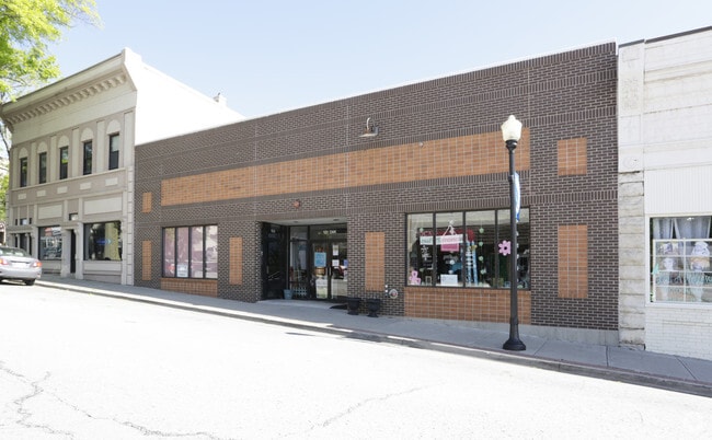
Property Record
133 Oak St, Bonner Springs, KS 66012
NEARBY LISTINGS FOR SALE OR LEASE
Property Detail
133 Oak St
Kansas City, MO-KS
Tiblow
191361
TIBLOW & 1914, S29, T11, R23, ACRES 0.190000, B7 SE 59.25 OF NW 100FT L1
Storemultistory
Wyandotte
X
Kansas
20209C0117E
1
2024
0.19 AC
2024
Kansas City KS
044900
Kansas City
7,468 SF
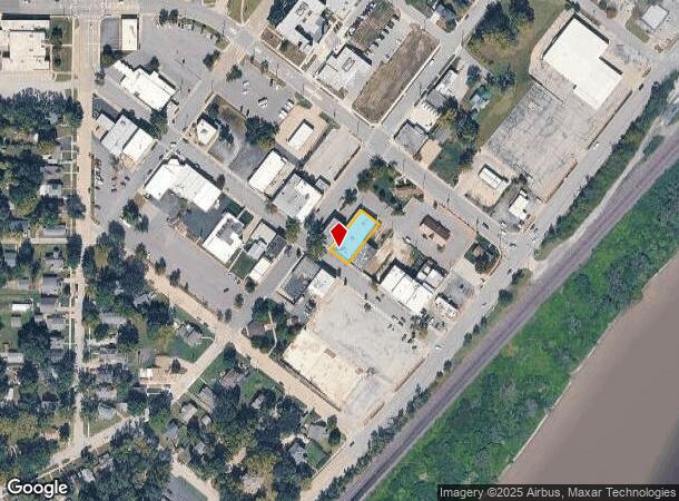
DEMOGRAPHICS near 133 Oak St
1 Mile
3 Mile
5 Mile
2024 Total Population
4,044
19,308
43,786
2029 Population
3,934
19,505
44,461
Pop Growth 2024-2029
(2.72%)
+ 1.02%
+ 1.54%
Average Age
38
37
38
2024 Total Households
1,590
6,680
15,349
HH Growth 2024-2029
(2.83%)
+ 0.76%
+ 1.41%
Median Household Inc
$66,853
$111,923
$109,372
Avg Household Size
2.50
2.90
2.80
2024 Avg HH Vehicles
2.00
2.00
2.00
Median Home Value
$180,580
$295,825
$313,409
Median Year Built
1963
1993
1998
Nearby Places
Map Layers
Map Styles
 Street
 Aerial
- Restaurants
- Banks
- Shops
- Fitness
- Groceries
PUBLIC TRANSPORTATION
AIRPORT
Kansas City International
DRIVE
WALK
Distance
Kansas City International
40 min
31.2 mi
SALE & LEASE HISTORY
LISTING DATE
SALE/LEASE

Nov 13, 2024
For Sale
Nearby Properties
Address
Land Use
TOTAL SIZE
Lot Size
Zoning
Address
Land Use
TOTAL SIZE
Lot Size
Zoning
276,310 SF
23.27 AC
PI
Address
Land Use
TOTAL SIZE
Lot Size
Zoning
50,750 SF
42.95 AC
I-1
Address
Land Use
TOTAL SIZE
Lot Size
Zoning
66,916 SF
14.72 AC
AG
Address
Land Use
TOTAL SIZE
Lot Size
Zoning
80,190 SF
16.86 AC
R-1
Address
Land Use
TOTAL SIZE
Lot Size
Zoning
297,198 SF
60.55 AC
Address
Land Use
TOTAL SIZE
Lot Size
Zoning
170,000 SF
12.71 AC
PI
Address
Land Use
TOTAL SIZE
Lot Size
Zoning
170,000 SF
12.71 AC
PI
Address
Land Use
TOTAL SIZE
Lot Size
Zoning
170,000 SF
14.87 AC
PI
Address
Land Use
TOTAL SIZE
Lot Size
Zoning
170,000 SF
12.72 AC
PI
Address
Land Use
TOTAL SIZE
Lot Size
Zoning
575,616 SF
35.52 AC
PI
Address
Land Use
TOTAL SIZE
Lot Size
Zoning
28,210 SF
317.17 AC
Address
Land Use
TOTAL SIZE
Lot Size
Zoning
146,336 SF
115.81 AC
A1
Address
Land Use
TOTAL SIZE
Lot Size
Zoning
6,380 SF
296.16 AC
BA1
Address
Land Use
TOTAL SIZE
Lot Size
Zoning
161,076 SF
20.27 AC
CH
Address
Land Use
TOTAL SIZE
Lot Size
Zoning
27,784 SF
1.52 AC
BC1
Address
Land Use
TOTAL SIZE
Lot Size
Zoning
36,712 SF
8.70 AC
PUDMR
Address
Land Use
TOTAL SIZE
Lot Size
Zoning
9,157 SF
1.46 AC
PUDMR
Address
Land Use
TOTAL SIZE
Lot Size
Zoning
19,113 SF
2.06 AC
BA2
Address
Land Use
TOTAL SIZE
Lot Size
Zoning
10,540 SF
15.05 AC
AG
Address
Land Use
TOTAL SIZE
Lot Size
Zoning
167,873 SF
17.80 AC
BR2
Address
Land Use
TOTAL SIZE
Lot Size
Zoning
7,167 SF
1.01 AC
BR2
Address
Land Use
TOTAL SIZE
Lot Size
Zoning
57,743 SF
6.18 AC
BR2
Address
Land Use
TOTAL SIZE
Lot Size
Zoning
154.64 AC
WC
Address
Land Use
TOTAL SIZE
Lot Size
Zoning
3,944 SF
38.11 AC
BR
Address
Land Use
TOTAL SIZE
Lot Size
Zoning
15,657 SF
1.46 AC
Address
Land Use
TOTAL SIZE
Lot Size
Zoning
20,354 SF
12.54 AC
BI1
Address
Land Use
TOTAL SIZE
Lot Size
Zoning
27,277 SF
3.34 AC
PUDMR
Address
Land Use
TOTAL SIZE
Lot Size
Zoning
43,776 SF
34.23 AC
I-2
Address
Land Use
TOTAL SIZE
Lot Size
Zoning
18,356 SF
2.80 AC
PUDMR
Address
Land Use
TOTAL SIZE
Lot Size
Zoning
65,834 SF
5.39 AC
PI
The World's #1 Commercial Real Estate Marketplace
Connect with us
© 2025 CoStar Group
The information above has been obtained from sources believed reliable. While we do not doubt its accuracy we have not verified it and make no guarantee, warranty or representation about it. It is your responsibility to independently confirm its accuracy and completeness. Any projections, opinions, assumptions, or estimates used are for example only and do not represent the current or future performance of the property. The value of this transaction to you depends on tax and other factors which should be evaluated by your tax, financial, and legal advisors. You and your advisors should conduct a careful, independent investigation of the property to determine to your satisfaction the suitability of the property for your needs.