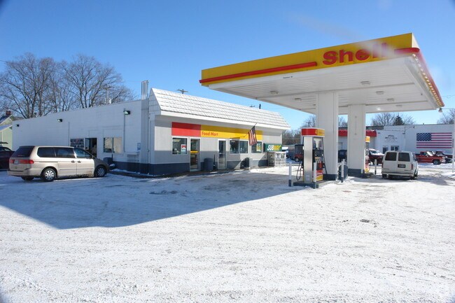
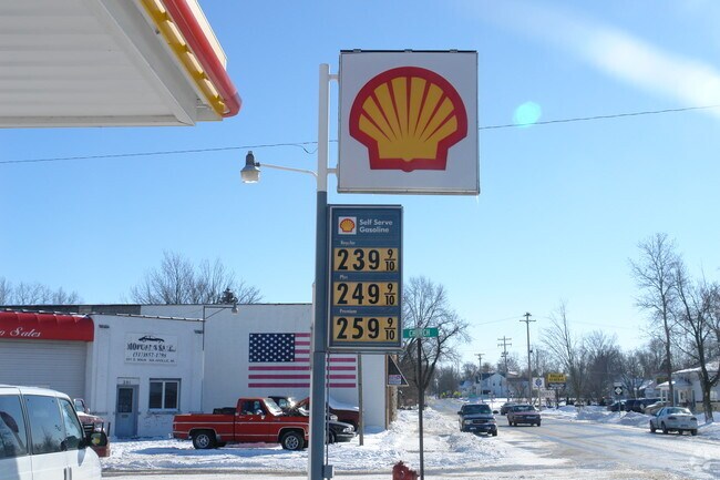
Property Record
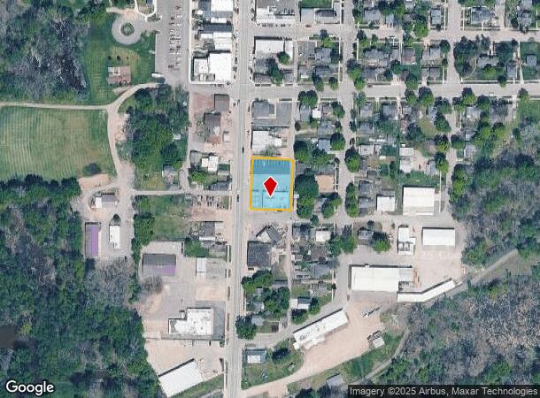
133 S Main St, Nashville, MI 49073
NEARBY LISTINGS FOR SALE OR LEASE
-
-
View all Nashville listings for sale on LoopNet.com
Property Detail
133 S Main St
Grand Rapids-Wyoming, MI
Phillips Addition
52-170-006-00
LOT 6 PLAT OF PHILLIPS ADDITION. 0.167 ACRES
Conveniencestore
Barry
X
Michigan
26045C0275E
6
2024
0.17 AC
2025
Barry County
010100
West Michigan
3,479 SF
DEMOGRAPHICS near 133 S Main St
1 Mile
3 Mile
5 Mile
2024 Total Population
1,579
2,731
6,093
2029 Population
1,641
2,821
6,277
Pop Growth 2024-2029
+ 3.93%
+ 3.30%
+ 3.02%
Average Age
40
40
41
2024 Total Households
629
1,064
2,364
HH Growth 2024-2029
+ 3.97%
+ 3.29%
+ 3.09%
Median Household Inc
$43,043
$48,905
$49,961
Avg Household Size
2.50
2.60
2.60
2024 Avg HH Vehicles
2.00
2.00
2.00
Median Home Value
$107,721
$146,453
$154,924
Median Year Built
1947
1948
1969
Nearby Places
Map Layers
Map Styles
 Street
 Aerial
- Restaurants
- Banks
- Shops
- Fitness
- Groceries
PUBLIC TRANSPORTATION
AIRPORT
Gerald R Ford International
DRIVE
WALK
Distance
Gerald R Ford International
62 min
36.6 mi
Capital Region International
DRIVE
WALK
Distance
Capital Region International
57 min
38.9 mi
Freight Ports
Port of Toledo
DRIVE
WALK
Distance
Port of Toledo
186 min
129.0 mi
Nearby Properties
Address
Land Use
TOTAL SIZE
Lot Size
Zoning
Address
Land Use
TOTAL SIZE
Lot Size
Zoning
109.35 AC
AG
Address
Land Use
TOTAL SIZE
Lot Size
Zoning
21,058 SF
1.54 AC
R1
Address
Land Use
TOTAL SIZE
Lot Size
Zoning
3,591 SF
138.90 AC
LA
Address
Land Use
TOTAL SIZE
Lot Size
Zoning
2,304 SF
212.64 AC
LA
Address
Land Use
TOTAL SIZE
Lot Size
Zoning
199.10 AC
AGRICULTUR
Address
Land Use
TOTAL SIZE
Lot Size
Zoning
12,554 SF
8.30 AC
AG
Address
Land Use
TOTAL SIZE
Lot Size
Zoning
99.90 AC
AGRICULTUR
Address
Land Use
TOTAL SIZE
Lot Size
Zoning
10,465 SF
1.62 AC
R1
Address
Land Use
TOTAL SIZE
Lot Size
Zoning
110.30 AC
LA
Address
Land Use
TOTAL SIZE
Lot Size
Zoning
85.30 AC
AG
Address
Land Use
TOTAL SIZE
Lot Size
Zoning
160.20 AC
AGRICULTUR
Address
Land Use
TOTAL SIZE
Lot Size
Zoning
2,246 SF
91.44 AC
LA
Address
Land Use
TOTAL SIZE
Lot Size
Zoning
93.44 AC
AG
Address
Land Use
TOTAL SIZE
Lot Size
Zoning
9,372 SF
1.19 AC
B1
Address
Land Use
TOTAL SIZE
Lot Size
Zoning
27,248 SF
2.90 AC
R2
Address
Land Use
TOTAL SIZE
Lot Size
Zoning
16,560 SF
8.12 AC
B1
Address
Land Use
TOTAL SIZE
Lot Size
Zoning
1,528 SF
120 AC
LA
Address
Land Use
TOTAL SIZE
Lot Size
Zoning
2,378 SF
108 AC
LA
Address
Land Use
TOTAL SIZE
Lot Size
Zoning
116.40 AC
AGRICULTUR
Address
Land Use
TOTAL SIZE
Lot Size
Zoning
111 AC
AG
Address
Land Use
TOTAL SIZE
Lot Size
Zoning
3,591 SF
69 AC
LA
Address
Land Use
TOTAL SIZE
Lot Size
Zoning
1,676 SF
78.99 AC
LA
Address
Land Use
TOTAL SIZE
Lot Size
Zoning
21,150 SF
4.80 AC
B1
Address
Land Use
TOTAL SIZE
Lot Size
Zoning
97.80 AC
Address
Land Use
TOTAL SIZE
Lot Size
Zoning
1,392 SF
101.10 AC
LA
Address
Land Use
TOTAL SIZE
Lot Size
Zoning
127 AC
AGRICULTUR
Address
Land Use
TOTAL SIZE
Lot Size
Zoning
1,864 SF
80 AC
LA
Address
Land Use
TOTAL SIZE
Lot Size
Zoning
80.02 AC
AG
Address
Land Use
TOTAL SIZE
Lot Size
Zoning
2,352 SF
73.15 AC
LA
Address
Land Use
TOTAL SIZE
Lot Size
Zoning
19,078 SF
3.28 AC
R1
The World's #1 Commercial Real Estate Marketplace
Connect with us
© 2026 CoStar Group
The information above has been obtained from sources believed reliable. While we do not doubt its accuracy we have not verified it and make no guarantee, warranty or representation about it. It is your responsibility to independently confirm its accuracy and completeness. Any projections, opinions, assumptions, or estimates used are for example only and do not represent the current or future performance of the property. The value of this transaction to you depends on tax and other factors which should be evaluated by your tax, financial, and legal advisors. You and your advisors should conduct a careful, independent investigation of the property to determine to your satisfaction the suitability of the property for your needs.