Property Record
133 Telegraph Rd, Vader, WA 98593
NEARBY LISTINGS FOR SALE OR LEASE
-
-
View all Vader listings for sale on LoopNet.com
Property Detail
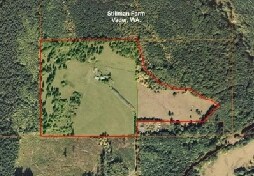
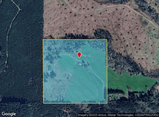
133 Telegraph Rd
012392-000-000
SECTION 21 TOWNSHIP 11N RANGE 02W SE4 SE4
Agriculturalland
Lewis
2024
Washington
2025
40 AC
971600
Other Market Areas
1,832 SF
Centralia, WA
DEMOGRAPHICS near 133 Telegraph Rd
1 mile
3 mile
5 mile
2024 Total Population
129
2,535
6,104
2029 Population
143
2,785
6,699
Pop Growth 2024-2029
+ 10.85%
+ 9.86%
+ 9.75%
Average Age
44
45
44
2024 Total Households
52
989
2,326
HH Growth 2024-2029
+ 9.62%
+ 9.91%
+ 9.76%
Median Household Inc
$69,999
$76,121
$81,017
Avg Household Size
2.40
2.50
2.60
2024 Avg HH Vehicles
3.00
3.00
3.00
Median Home Value
$369,230
$392,201
$368,063
Median Year Built
1983
1980
1978
Nearby Places
Map Layers
Map Styles
 Street
 Aerial
Transit
 Traffic
 Biking
Places
Listings with unknown addresses are not visible on the map
- Restaurants
- Banks
- Shops
- Fitness
- Groceries
Nearby Properties
Address
Land Use
TOTAL SIZE
Lot Size
Zoning
Address
Land Use
TOTAL SIZE
Lot Size
Zoning
19,560 SF
7.21 AC
FC
Address
Land Use
TOTAL SIZE
Lot Size
Zoning
4,025 SF
4.55 AC
ARL
Address
Land Use
TOTAL SIZE
Lot Size
Zoning
3,456 SF
3 AC
CM
Address
Land Use
TOTAL SIZE
Lot Size
Zoning
29,440 SF
19.46 AC
RDD20
Address
Land Use
TOTAL SIZE
Lot Size
Zoning
2.50 AC
RDD10
Address
Land Use
TOTAL SIZE
Lot Size
Zoning
1,753 SF
11.96 AC
FC
Address
Land Use
TOTAL SIZE
Lot Size
Zoning
6.01 AC
RDD5
Address
Land Use
TOTAL SIZE
Lot Size
Zoning
6,588 SF
6.40 AC
RDD20
Address
Land Use
TOTAL SIZE
Lot Size
Zoning
4,717 SF
20.10 AC
RDD20
Address
Land Use
TOTAL SIZE
Lot Size
Zoning
2,725 SF
3.51 AC
RDD20
Address
Land Use
TOTAL SIZE
Lot Size
Zoning
3,225 SF
5 AC
RDD10
Address
Land Use
TOTAL SIZE
Lot Size
Zoning
4,866 SF
20 AC
RDD5
Address
Land Use
TOTAL SIZE
Lot Size
Zoning
4,173 SF
33.96 AC
RDD5
Address
Land Use
TOTAL SIZE
Lot Size
Zoning
2,611 SF
24.84 AC
RDD5
Address
Land Use
TOTAL SIZE
Lot Size
Zoning
3,664 SF
21.05 AC
ARL
Address
Land Use
TOTAL SIZE
Lot Size
Zoning
2,756 SF
19.55 AC
RDD20
Address
Land Use
TOTAL SIZE
Lot Size
Zoning
159.27 AC
ARL
Address
Land Use
TOTAL SIZE
Lot Size
Zoning
3,808 SF
11.39 AC
R1
Address
Land Use
TOTAL SIZE
Lot Size
Zoning
7,680 SF
3.38 AC
RAI
Address
Land Use
TOTAL SIZE
Lot Size
Zoning
1,562 SF
5.51 AC
FC
Address
Land Use
TOTAL SIZE
Lot Size
Zoning
5 AC
RDD20
Address
Land Use
TOTAL SIZE
Lot Size
Zoning
5,513 SF
4.85 AC
Address
Land Use
TOTAL SIZE
Lot Size
Zoning
3,773 SF
5.16 AC
RDD20
Address
Land Use
TOTAL SIZE
Lot Size
Zoning
4,872 SF
5.13 AC
RDD10
Address
Land Use
TOTAL SIZE
Lot Size
Zoning
3,818 SF
12.85 AC
UZ0
Address
Land Use
TOTAL SIZE
Lot Size
Zoning
3,144 SF
5 AC
RDD20
Address
Land Use
TOTAL SIZE
Lot Size
Zoning
4,444 SF
5.01 AC
UZ0
Address
Land Use
TOTAL SIZE
Lot Size
Zoning
4,404 SF
13.25 AC
RDD20
Address
Land Use
TOTAL SIZE
Lot Size
Zoning
2,856 SF
6.37 AC
RDD5
The World's #1 Commercial Real Estate Marketplace
Connect with us
© 2026 CoStar Group
The information above has been obtained from sources believed reliable. While we do not doubt its accuracy we have not verified it and make no guarantee, warranty or representation about it. It is your responsibility to independently confirm its accuracy and completeness. Any projections, opinions, assumptions, or estimates used are for example only and do not represent the current or future performance of the property. The value of this transaction to you depends on tax and other factors which should be evaluated by your tax, financial, and legal advisors. You and your advisors should conduct a careful, independent investigation of the property to determine to your satisfaction the suitability of the property for your needs.