Property Record
1330 20Th St Se, Naples, FL 34117
NEARBY LISTINGS FOR SALE OR LEASE
-
-
View all Naples listings for sale on LoopNet.com
Property Detail
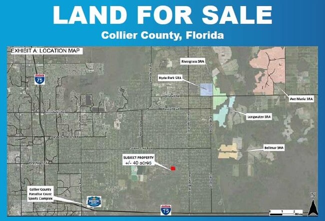
1330 20Th St Se
00301320007
Acreage Header
Countyproperty
13 49 27 E1/2 OF NW1/4 OF NE1/4 OF SW1/4, NE1/4 OF NE1/4 OF SW1/4
AH
Collier
12021C0430H
Florida
2024
40 AC
2025
Outlying Collier County
010428
Southwest Florida
2,515 SF
Naples-Immokalee-Marco Island, FL
DEMOGRAPHICS near 1330 20Th St Se
1 Mile
3 Mile
5 Mile
2024 Total Population
712
8,179
18,928
2029 Population
777
8,973
20,809
Pop Growth 2024-2029
+ 9.13%
+ 9.71%
+ 9.94%
Average Age
38
37
38
2024 Total Households
213
2,414
5,678
HH Growth 2024-2029
+ 7.98%
+ 8.74%
+ 9.05%
Median Household Inc
$77,155
$69,154
$69,487
Avg Household Size
3.10
3.10
3.10
2024 Avg HH Vehicles
3.00
3.00
2.00
Median Home Value
$299,389
$339,269
$334,408
Median Year Built
1998
1999
1998
Nearby Places
Map Layers
Map Styles
 Street
 Aerial
- Restaurants
- Banks
- Shops
- Fitness
- Groceries
PUBLIC TRANSPORTATION
AIRPORT
Southwest Florida International
DRIVE
WALK
Distance
Southwest Florida International
58 min
38.5 mi
Freight Ports
Port Everglades
DRIVE
WALK
Distance
Port Everglades
134 min
108.9 mi
SALE & LEASE HISTORY
LISTING DATE
SALE/LEASE

Apr 21, 2023
For Sale
Nearby Properties
Address
Land Use
TOTAL SIZE
Lot Size
Zoning
Address
Land Use
TOTAL SIZE
Lot Size
Zoning
123,937 SF
32.80 AC
E
Address
Land Use
TOTAL SIZE
Lot Size
Zoning
35,856 SF
5.14 AC
CPUD
Address
Land Use
TOTAL SIZE
Lot Size
Zoning
21,848 SF
4.03 AC
E
Address
Land Use
TOTAL SIZE
Lot Size
Zoning
199.51 AC
A
Address
Land Use
TOTAL SIZE
Lot Size
Zoning
13,496 SF
5.46 AC
E
Address
Land Use
TOTAL SIZE
Lot Size
Zoning
12,492 SF
391.96 AC
PUD
Address
Land Use
TOTAL SIZE
Lot Size
Zoning
4,139 SF
115 AC
A
Address
Land Use
TOTAL SIZE
Lot Size
Zoning
12,841 SF
7.73 AC
E
Address
Land Use
TOTAL SIZE
Lot Size
Zoning
3,272 SF
20 AC
A
Address
Land Use
TOTAL SIZE
Lot Size
Zoning
2,950 SF
4.90 AC
A
Address
Land Use
TOTAL SIZE
Lot Size
Zoning
4,280 SF
2.73 AC
E
Address
Land Use
TOTAL SIZE
Lot Size
Zoning
2.08 AC
Address
Land Use
TOTAL SIZE
Lot Size
Zoning
9,391 SF
5 AC
A
Address
Land Use
TOTAL SIZE
Lot Size
Zoning
6,317 SF
4.47 AC
A
Address
Land Use
TOTAL SIZE
Lot Size
Zoning
2,115 SF
4.90 AC
A
Address
Land Use
TOTAL SIZE
Lot Size
Zoning
1,756 SF
35 AC
A
Address
Land Use
TOTAL SIZE
Lot Size
Zoning
2,217 SF
55 AC
A
Address
Land Use
TOTAL SIZE
Lot Size
Zoning
1,882 SF
4.90 AC
A
Address
Land Use
TOTAL SIZE
Lot Size
Zoning
1,820 SF
5 AC
A
Address
Land Use
TOTAL SIZE
Lot Size
Zoning
2,628 SF
5 AC
E
Address
Land Use
TOTAL SIZE
Lot Size
Zoning
4,925 SF
5 AC
A
Address
Land Use
TOTAL SIZE
Lot Size
Zoning
1,564 SF
1.59 AC
E
Address
Land Use
TOTAL SIZE
Lot Size
Zoning
1,079 SF
4.90 AC
A
Address
Land Use
TOTAL SIZE
Lot Size
Zoning
11,554 SF
12.73 AC
E
Address
Land Use
TOTAL SIZE
Lot Size
Zoning
2,262 SF
4.54 AC
E
Address
Land Use
TOTAL SIZE
Lot Size
Zoning
5,380 SF
17.88 AC
E
Address
Land Use
TOTAL SIZE
Lot Size
Zoning
7,984 SF
10 AC
A
Address
Land Use
TOTAL SIZE
Lot Size
Zoning
2,747 SF
10 AC
A
Address
Land Use
TOTAL SIZE
Lot Size
Zoning
2,797 SF
3.11 AC
E
Address
Land Use
TOTAL SIZE
Lot Size
Zoning
1,674 SF
5 AC
E
The World's #1 Commercial Real Estate Marketplace
Connect with us
© 2025 CoStar Group
The information above has been obtained from sources believed reliable. While we do not doubt its accuracy we have not verified it and make no guarantee, warranty or representation about it. It is your responsibility to independently confirm its accuracy and completeness. Any projections, opinions, assumptions, or estimates used are for example only and do not represent the current or future performance of the property. The value of this transaction to you depends on tax and other factors which should be evaluated by your tax, financial, and legal advisors. You and your advisors should conduct a careful, independent investigation of the property to determine to your satisfaction the suitability of the property for your needs.