Property Record
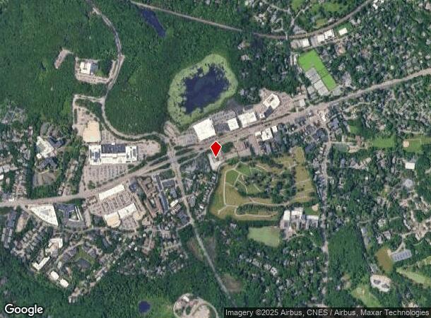
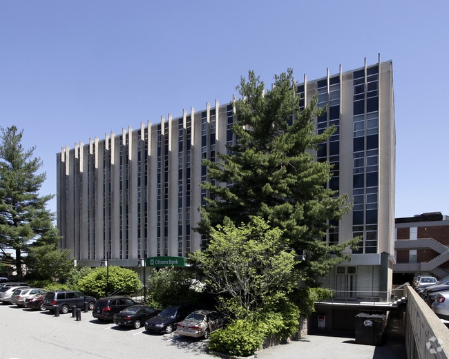
1330 Boylston St, Chestnut Hill, MA 02467

Current Lease Availabilities
NEARBY LISTINGS FOR SALE OR LEASE
Property Detail
1330 Boylston St
BROO-000425-000012
Norfolk
Officebuilding
Massachusetts
X
12
25021C0033E
2.16 AC
2025
Newton/Brookline
2025
Boston
401202
Boston-Cambridge-Newton, MA-NH
58,384 SF
DEMOGRAPHICS near 1330 Boylston St
1 Mile
3 Mile
5 Mile
2024 Total Population
10,025
196,485
675,962
2029 Population
9,883
190,630
655,937
Pop Growth 2024-2029
(1.42%)
(2.98%)
(2.96%)
Average Age
42
40
38
2024 Total Households
3,432
81,270
267,396
HH Growth 2024-2029
(1.46%)
(3.34%)
(3.26%)
Median Household Inc
$173,094
$116,794
$98,364
Avg Household Size
2.40
2.30
2.30
2024 Avg HH Vehicles
2.00
1.00
1.00
Median Home Value
$1,064,893
$947,949
$853,667
Median Year Built
1966
1949
1949
Nearby Places
Map Layers
Map Styles
 Street
 Aerial
- Restaurants
- Banks
- Shops
- Fitness
- Groceries
PUBLIC TRANSPORTATION
TRANSIT/SUBWAY
Chestnut Hill Station (Green Line - D - Massachusetts Bay Transportation Authority Subway (The T))
DRIVE
WALK
Distance
Chestnut Hill Station (Green Line - D - Massachusetts Bay Transportation Authority Subway (The T))
2 min
13 min
0.6 mi
COMMUTER RAIL
Highland (Needham Line - Massachusetts Bay Transportation Authority Commuter Rail (Purple Line))
DRIVE
WALK
Distance
Highland (Needham Line - Massachusetts Bay Transportation Authority Commuter Rail (Purple Line))
8 min
3.5 mi
Bellevue (Needham Line - Massachusetts Bay Transportation Authority Commuter Rail (Purple Line))
DRIVE
WALK
Distance
Bellevue (Needham Line - Massachusetts Bay Transportation Authority Commuter Rail (Purple Line))
8 min
3.6 mi
AIRPORT
General Edward Lawrence Logan International
DRIVE
WALK
Distance
General Edward Lawrence Logan International
21 min
10.5 mi
Freight Ports
Port of Boston
DRIVE
WALK
Distance
Port of Boston
19 min
8.8 mi
Nearby Properties
Address
Land Use
TOTAL SIZE
Lot Size
Zoning
Address
Land Use
TOTAL SIZE
Lot Size
Zoning
150,192 SF
10.27 AC
E
Address
Land Use
TOTAL SIZE
Lot Size
Zoning
30,845 SF
50.36 AC
SR1
Address
Land Use
TOTAL SIZE
Lot Size
Zoning
387,550 SF
7.99 AC
MU1
Address
Land Use
TOTAL SIZE
Lot Size
Zoning
506,534 SF
2.75 AC
C
Address
Land Use
TOTAL SIZE
Lot Size
Zoning
412,208 SF
7.93 AC
I
Address
Land Use
TOTAL SIZE
Lot Size
Zoning
30,170 SF
19 AC
SR2
Address
Land Use
TOTAL SIZE
Lot Size
Zoning
147,997 SF
2.03 AC
GMR2
Address
Land Use
TOTAL SIZE
Lot Size
Zoning
228,483 SF
7.57 AC
BU1
Address
Land Use
TOTAL SIZE
Lot Size
Zoning
317,049 SF
11.22 AC
M05
Address
Land Use
TOTAL SIZE
Lot Size
Zoning
1,050 SF
8.77 AC
BU4
Address
Land Use
TOTAL SIZE
Lot Size
Zoning
14.59 AC
S40
Address
Land Use
TOTAL SIZE
Lot Size
Zoning
203,252 SF
236.88 AC
S40
Address
Land Use
TOTAL SIZE
Lot Size
Zoning
45,000 SF
14.30 AC
E
Address
Land Use
TOTAL SIZE
Lot Size
Zoning
134,136 SF
1.35 AC
M25
Address
Land Use
TOTAL SIZE
Lot Size
Zoning
157,828 SF
4.39 AC
E
Address
Land Use
TOTAL SIZE
Lot Size
Zoning
163,364 SF
3.08 AC
O10
Address
Land Use
TOTAL SIZE
Lot Size
Zoning
351,680 SF
4.01 AC
RC
Address
Land Use
TOTAL SIZE
Lot Size
Zoning
62,924 SF
3.97 AC
T-5
Address
Land Use
TOTAL SIZE
Lot Size
Zoning
4.74 AC
NEBC
Address
Land Use
TOTAL SIZE
Lot Size
Zoning
241,737 SF
4.67 AC
BU1
Address
Land Use
TOTAL SIZE
Lot Size
Zoning
25,744 SF
35.80 AC
S40
Address
Land Use
TOTAL SIZE
Lot Size
Zoning
103,030 SF
0.77 AC
G175
Address
Land Use
TOTAL SIZE
Lot Size
Zoning
76,800 SF
22.65 AC
MU1
Address
Land Use
TOTAL SIZE
Lot Size
Zoning
5,119 SF
119.98 AC
S15
Address
Land Use
TOTAL SIZE
Lot Size
Zoning
191,142 SF
1.08 AC
A
Address
Land Use
TOTAL SIZE
Lot Size
Zoning
286,928 SF
2.89 AC
BU1
Address
Land Use
TOTAL SIZE
Lot Size
Zoning
181,164 SF
0.85 AC
M25
Address
Land Use
TOTAL SIZE
Lot Size
Zoning
215,662 SF
1.87 AC
A
Address
Land Use
TOTAL SIZE
Lot Size
Zoning
151,232 SF
8.27 AC
PUB
Address
Land Use
TOTAL SIZE
Lot Size
Zoning
220,500 SF
1.96 AC
NEBC
The World's #1 Commercial Real Estate Marketplace
Connect with us
© 2026 CoStar Group
The information above has been obtained from sources believed reliable. While we do not doubt its accuracy we have not verified it and make no guarantee, warranty or representation about it. It is your responsibility to independently confirm its accuracy and completeness. Any projections, opinions, assumptions, or estimates used are for example only and do not represent the current or future performance of the property. The value of this transaction to you depends on tax and other factors which should be evaluated by your tax, financial, and legal advisors. You and your advisors should conduct a careful, independent investigation of the property to determine to your satisfaction the suitability of the property for your needs.