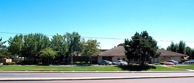
Property Record
1330 Florin Rd, Sacramento, CA 95831

NEARBY LISTINGS FOR SALE OR LEASE
Property Detail
1330 Florin Rd
031-0620-002
POR SEC 2, T7N, R4E, MDB&M DES AS BEG AT A PT ONTHE S LINE OF FLORIN RD LOC N 88%1410 E 482 FT FR THE NE COR OF LOT A S LAND
Financialbuilding
Sacramento
X
California
06067C0285H
a
2024
2.73 AC
2025
South Sacramento
004013
Sacramento
11,899 SF
Sacramento--Roseville--Arden-Arcade, CA
DEMOGRAPHICS near 1330 Florin Rd
1 Mile
3 Mile
5 Mile
2024 Total Population
16,215
120,879
293,269
2029 Population
16,287
121,555
295,436
Pop Growth 2024-2029
+ 0.44%
+ 0.56%
+ 0.74%
Average Age
42
40
38
2024 Total Households
6,281
43,726
102,551
HH Growth 2024-2029
+ 0.43%
+ 0.53%
+ 0.73%
Median Household Inc
$85,517
$75,291
$72,161
Avg Household Size
2.50
2.70
2.70
2024 Avg HH Vehicles
2.00
2.00
2.00
Median Home Value
$497,913
$481,704
$447,345
Median Year Built
1969
1972
1972
Nearby Places
Map Layers
Map Styles
 Street
 Aerial
- Restaurants
- Banks
- Shops
- Fitness
- Groceries
PUBLIC TRANSPORTATION
COMMUTER RAIL
DRIVE
WALK
Distance
11 min
7.4 mi
AIRPORT
Sacramento International
DRIVE
WALK
Distance
Sacramento International
24 min
17.7 mi
Freight Ports
Port of Stockton
DRIVE
WALK
Distance
Port of Stockton
47 min
40.4 mi
Nearby Properties
Address
Land Use
TOTAL SIZE
Lot Size
Zoning
Address
Land Use
TOTAL SIZE
Lot Size
Zoning
12.70 AC
SC-PUD
Address
Land Use
TOTAL SIZE
Lot Size
Zoning
253,984 SF
11.58 AC
R-2B-PUD
Address
Land Use
TOTAL SIZE
Lot Size
Zoning
165,704 SF
9.57 AC
R-2B-R
Address
Land Use
TOTAL SIZE
Lot Size
Zoning
180,344 SF
11.86 AC
R-2A
Address
Land Use
TOTAL SIZE
Lot Size
Zoning
175,855 SF
8.90 AC
R-2B-R-PUD
Address
Land Use
TOTAL SIZE
Lot Size
Zoning
170,514 SF
9 AC
R-2B-R-PUD
Address
Land Use
TOTAL SIZE
Lot Size
Zoning
213,260 SF
14.35 AC
R-3-R
Address
Land Use
TOTAL SIZE
Lot Size
Zoning
173,323 SF
10.39 AC
C-2-PUD
Address
Land Use
TOTAL SIZE
Lot Size
Zoning
13.87 AC
C-2-PUD
Address
Land Use
TOTAL SIZE
Lot Size
Zoning
140,408 SF
5.90 AC
R-3
Address
Land Use
TOTAL SIZE
Lot Size
Zoning
166,941 SF
7.46 AC
R-2B-PUD
Address
Land Use
TOTAL SIZE
Lot Size
Zoning
64,082 SF
2.38 AC
R-1
Address
Land Use
TOTAL SIZE
Lot Size
Zoning
187,708 SF
13.50 AC
C-2-PUD
Address
Land Use
TOTAL SIZE
Lot Size
Zoning
186.36 AC
R-1-PUD R-
Address
Land Use
TOTAL SIZE
Lot Size
Zoning
156,873 SF
14.98 AC
C-2-PUD
Address
Land Use
TOTAL SIZE
Lot Size
Zoning
267,580 SF
16.12 AC
R-1A
Address
Land Use
TOTAL SIZE
Lot Size
Zoning
102,930 SF
4.87 AC
R-3
Address
Land Use
TOTAL SIZE
Lot Size
Zoning
181,766 SF
4.79 AC
R-4-PUD R-
Address
Land Use
TOTAL SIZE
Lot Size
Zoning
137,916 SF
11.62 AC
SC-R
Address
Land Use
TOTAL SIZE
Lot Size
Zoning
227,396 SF
15.76 AC
R-2A-R-EA-
Address
Land Use
TOTAL SIZE
Lot Size
Zoning
91,586 SF
6.03 AC
R-3-R
Address
Land Use
TOTAL SIZE
Lot Size
Zoning
85,131 SF
7.40 AC
C-2-PUD
Address
Land Use
TOTAL SIZE
Lot Size
Zoning
84,087 SF
4.11 AC
R-3-R
Address
Land Use
TOTAL SIZE
Lot Size
Zoning
162,259 SF
12.73 AC
R-3
Address
Land Use
TOTAL SIZE
Lot Size
Zoning
165,523 SF
15.76 AC
A-PUD OB-P
Address
Land Use
TOTAL SIZE
Lot Size
Zoning
45,949 SF
4.24 AC
R-2A
Address
Land Use
TOTAL SIZE
Lot Size
Zoning
6.34 AC
C-2-PUD
Address
Land Use
TOTAL SIZE
Lot Size
Zoning
106,803 SF
7.18 AC
R-2A-R
Address
Land Use
TOTAL SIZE
Lot Size
Zoning
29.28 AC
C-2-PUD
Address
Land Use
TOTAL SIZE
Lot Size
Zoning
85,429 SF
3.67 AC
F C-2-R
The World's #1 Commercial Real Estate Marketplace
Connect with us
© 2026 CoStar Group
The information above has been obtained from sources believed reliable. While we do not doubt its accuracy we have not verified it and make no guarantee, warranty or representation about it. It is your responsibility to independently confirm its accuracy and completeness. Any projections, opinions, assumptions, or estimates used are for example only and do not represent the current or future performance of the property. The value of this transaction to you depends on tax and other factors which should be evaluated by your tax, financial, and legal advisors. You and your advisors should conduct a careful, independent investigation of the property to determine to your satisfaction the suitability of the property for your needs.