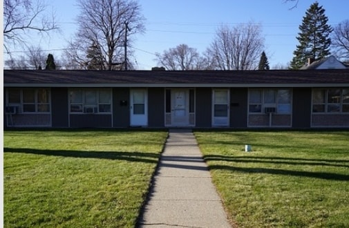
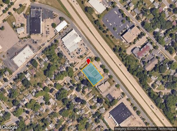
Property Record
1330 N Stoughton Rd, Madison, WI 53714
NEARBY LISTINGS FOR SALE OR LEASE
Property Detail
1330 N Stoughton Rd
Madison, WI
Washington Heights
0810-333-0304-1
WASHINGTON HEIGHTS NW 200 FT OF SW 130 F T OF OL B
Commercialnec
Dane
X
Wisconsin
55025C0427H
b
2024
0.60 AC
2024
Hawthorne
002601
Milwaukee/Madison
6,720 SF
DEMOGRAPHICS near 1330 N Stoughton Rd
1 Mile
3 Mile
5 Mile
2024 Total Population
5,544
71,096
153,703
2029 Population
5,710
73,880
158,952
Pop Growth 2024-2029
+ 2.99%
+ 3.92%
+ 3.42%
Average Age
38
40
37
2024 Total Households
2,478
33,470
70,591
HH Growth 2024-2029
+ 3.03%
+ 4.00%
+ 3.59%
Median Household Inc
$50,351
$67,094
$64,249
Avg Household Size
2.10
2.10
2.00
2024 Avg HH Vehicles
1.00
2.00
1.00
Median Home Value
$194,614
$260,554
$280,401
Median Year Built
1971
1971
1976
Nearby Places
Map Layers
Map Styles
 Street
 Aerial
- Restaurants
- Banks
- Shops
- Fitness
- Groceries
PUBLIC TRANSPORTATION
AIRPORT
Dane County Regional/Truax Field
DRIVE
WALK
Distance
Dane County Regional/Truax Field
8 min
3.8 mi
Freight Ports
Port Milwaukee
DRIVE
WALK
Distance
Port Milwaukee
88 min
75.8 mi
Nearby Properties
Address
Land Use
TOTAL SIZE
Lot Size
Zoning
Address
Land Use
TOTAL SIZE
Lot Size
Zoning
27.70 AC
SEC
Address
Land Use
TOTAL SIZE
Lot Size
Zoning
509,946 SF
40.17 AC
IL
Address
Land Use
TOTAL SIZE
Lot Size
Zoning
461,454 SF
3.37 AC
CC-T
Address
Land Use
TOTAL SIZE
Lot Size
Zoning
251,632 SF
3.88 AC
TE
Address
Land Use
TOTAL SIZE
Lot Size
Zoning
289,884 SF
19.36 AC
SR-V2
Address
Land Use
TOTAL SIZE
Lot Size
Zoning
97,580 SF
6.86 AC
TR-U1
Address
Land Use
TOTAL SIZE
Lot Size
Zoning
357,427 SF
12.77 AC
PD
Address
Land Use
TOTAL SIZE
Lot Size
Zoning
13,440 SF
10.98 AC
IL
Address
Land Use
TOTAL SIZE
Lot Size
Zoning
216,017 SF
3.35 AC
TE
Address
Land Use
TOTAL SIZE
Lot Size
Zoning
372,177 SF
19.47 AC
SR-V2
Address
Land Use
TOTAL SIZE
Lot Size
Zoning
294,106 SF
29.06 AC
CC
Address
Land Use
TOTAL SIZE
Lot Size
Zoning
104,000 SF
11.21 AC
CC-T
Address
Land Use
TOTAL SIZE
Lot Size
Zoning
316,954 SF
24.96 AC
SEC
Address
Land Use
TOTAL SIZE
Lot Size
Zoning
101,348 SF
6.37 AC
SEC
Address
Land Use
TOTAL SIZE
Lot Size
Zoning
58,680 SF
6.29 AC
PD
Address
Land Use
TOTAL SIZE
Lot Size
Zoning
6.76 AC
SEC
Address
Land Use
TOTAL SIZE
Lot Size
Zoning
Address
Land Use
TOTAL SIZE
Lot Size
Zoning
92,130 SF
3.36 AC
PD
Address
Land Use
TOTAL SIZE
Lot Size
Zoning
167,519 SF
4.51 AC
PD
Address
Land Use
TOTAL SIZE
Lot Size
Zoning
105,743 SF
9.50 AC
IG
Address
Land Use
TOTAL SIZE
Lot Size
Zoning
37,133 SF
4.71 AC
CC-T
Address
Land Use
TOTAL SIZE
Lot Size
Zoning
191,145 SF
12.24 AC
SR-V2
Address
Land Use
TOTAL SIZE
Lot Size
Zoning
149,650 SF
21.35 AC
CC
Address
Land Use
TOTAL SIZE
Lot Size
Zoning
154,403 SF
1.21 AC
PD
Address
Land Use
TOTAL SIZE
Lot Size
Zoning
101,080 SF
1.02 AC
CC-T
Address
Land Use
TOTAL SIZE
Lot Size
Zoning
176,496 SF
3.51 AC
PD
Address
Land Use
TOTAL SIZE
Lot Size
Zoning
68,016 SF
6.45 AC
PD
Address
Land Use
TOTAL SIZE
Lot Size
Zoning
171,950 SF
11.28 AC
PD
Address
Land Use
TOTAL SIZE
Lot Size
Zoning
134,008 SF
5.63 AC
SR-V2
Address
Land Use
TOTAL SIZE
Lot Size
Zoning
95,909 SF
1 AC
TE
The World's #1 Commercial Real Estate Marketplace
Connect with us
© 2025 CoStar Group
The information above has been obtained from sources believed reliable. While we do not doubt its accuracy we have not verified it and make no guarantee, warranty or representation about it. It is your responsibility to independently confirm its accuracy and completeness. Any projections, opinions, assumptions, or estimates used are for example only and do not represent the current or future performance of the property. The value of this transaction to you depends on tax and other factors which should be evaluated by your tax, financial, and legal advisors. You and your advisors should conduct a careful, independent investigation of the property to determine to your satisfaction the suitability of the property for your needs.