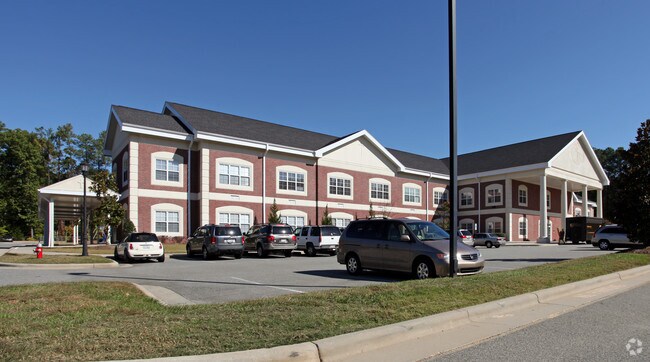
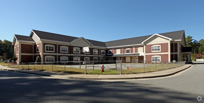
Property Record
1330 Old Apex Rd, Cary, NC 27513
NEARBY LISTINGS FOR SALE OR LEASE
Property Detail
1330 Old Apex Rd
0753.11-67-5316-000
Prop Of Young Partners Llc
Publicschool
PROP OF YOUNG PARTNERS LLC BM2003-01437
X
Wake
3720075300K
North Carolina
0
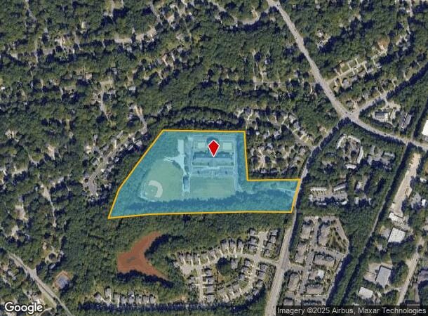
20.64 AC
2025
Cary
053525
Raleigh/Durham
66,088 SF
Raleigh, NC
DEMOGRAPHICS near 1330 Old Apex Rd
1 Mile
3 Mile
5 Mile
2024 Total Population
10,750
92,693
214,436
2029 Population
11,556
100,186
232,788
Pop Growth 2024-2029
+ 7.50%
+ 8.08%
+ 8.56%
Average Age
41
40
39
2024 Total Households
4,729
37,126
85,014
HH Growth 2024-2029
+ 7.44%
+ 8.09%
+ 8.59%
Median Household Inc
$86,726
$108,560
$105,500
Avg Household Size
2.20
2.40
2.50
2024 Avg HH Vehicles
2.00
2.00
2.00
Median Home Value
$338,567
$402,070
$427,399
Median Year Built
1987
1992
1996
Nearby Places
Map Layers
Map Styles
 Street
 Aerial
- Restaurants
- Banks
- Shops
- Fitness
- Groceries
PUBLIC TRANSPORTATION
COMMUTER RAIL
Cary Station (Piedmont - North Carolina by Train (NC Train))
DRIVE
WALK
Distance
Cary Station (Piedmont - North Carolina by Train (NC Train))
5 min
2.1 mi
AIRPORT
Raleigh-Durham International
DRIVE
WALK
Distance
Raleigh-Durham International
20 min
9.3 mi
Nearby Properties
Address
Land Use
TOTAL SIZE
Lot Size
Zoning
Address
Land Use
TOTAL SIZE
Lot Size
Zoning
693,180 SF
17.61 AC
GCM
Address
Land Use
TOTAL SIZE
Lot Size
Zoning
517,812 SF
18.51 AC
RMFP
Address
Land Use
TOTAL SIZE
Lot Size
Zoning
633,930 SF
23.01 AC
OI
Address
Land Use
TOTAL SIZE
Lot Size
Zoning
439,439 SF
30.59 AC
OICU
Address
Land Use
TOTAL SIZE
Lot Size
Zoning
534,604 SF
16.38 AC
RMFM
Address
Land Use
TOTAL SIZE
Lot Size
Zoning
433,914 SF
11.81 AC
MXD
Address
Land Use
TOTAL SIZE
Lot Size
Zoning
441,502 SF
15.42 AC
OIM
Address
Land Use
TOTAL SIZE
Lot Size
Zoning
429,107 SF
13.67 AC
RMFP
Address
Land Use
TOTAL SIZE
Lot Size
Zoning
450,107 SF
30.16 AC
HD MF
Address
Land Use
TOTAL SIZE
Lot Size
Zoning
375,689 SF
32.73 AC
HDR
Address
Land Use
TOTAL SIZE
Lot Size
Zoning
312,475 SF
21.74 AC
RMFP
Address
Land Use
TOTAL SIZE
Lot Size
Zoning
453,970 SF
41.48 AC
RMF-C
Address
Land Use
TOTAL SIZE
Lot Size
Zoning
220,152 SF
67.76 AC
OIM
Address
Land Use
TOTAL SIZE
Lot Size
Zoning
444,236 SF
8.51 AC
ORDP
Address
Land Use
TOTAL SIZE
Lot Size
Zoning
269,702 SF
14.66 AC
GCM
Address
Land Use
TOTAL SIZE
Lot Size
Zoning
280,706 SF
15.38 AC
PUD-C
Address
Land Use
TOTAL SIZE
Lot Size
Zoning
368,195 SF
32.11 AC
HDR
Address
Land Use
TOTAL SIZE
Lot Size
Zoning
394,181 SF
28.62 AC
HDR
Address
Land Use
TOTAL SIZE
Lot Size
Zoning
364,972 SF
35.18 AC
RMF-C
Address
Land Use
TOTAL SIZE
Lot Size
Zoning
226,107 SF
18.72 AC
RMFP
Address
Land Use
TOTAL SIZE
Lot Size
Zoning
194,462 SF
21.62 AC
OICU
Address
Land Use
TOTAL SIZE
Lot Size
Zoning
330,232 SF
18.45 AC
OIP
Address
Land Use
TOTAL SIZE
Lot Size
Zoning
294,088 SF
24.72 AC
RMF-C
Address
Land Use
TOTAL SIZE
Lot Size
Zoning
287,626 SF
14.61 AC
MUPD
Address
Land Use
TOTAL SIZE
Lot Size
Zoning
319,271 SF
38.96 AC
R12
Address
Land Use
TOTAL SIZE
Lot Size
Zoning
285,822 SF
24.57 AC
RMFP
Address
Land Use
TOTAL SIZE
Lot Size
Zoning
270,753 SF
20.56 AC
RMFP
Address
Land Use
TOTAL SIZE
Lot Size
Zoning
185,064 SF
1.56 AC
GCP
Address
Land Use
TOTAL SIZE
Lot Size
Zoning
409,343 SF
35.26 AC
RMF-C
Address
Land Use
TOTAL SIZE
Lot Size
Zoning
209,936 SF
55.26 AC
R8
The World's #1 Commercial Real Estate Marketplace
Connect with us
© 2025 CoStar Group
The information above has been obtained from sources believed reliable. While we do not doubt its accuracy we have not verified it and make no guarantee, warranty or representation about it. It is your responsibility to independently confirm its accuracy and completeness. Any projections, opinions, assumptions, or estimates used are for example only and do not represent the current or future performance of the property. The value of this transaction to you depends on tax and other factors which should be evaluated by your tax, financial, and legal advisors. You and your advisors should conduct a careful, independent investigation of the property to determine to your satisfaction the suitability of the property for your needs.