Property Record
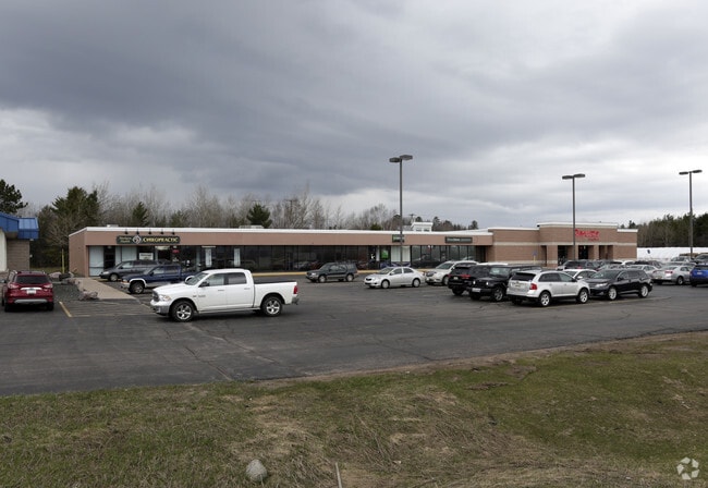
1330 Us Highway 41 W, Ishpeming, MI 49849

Property Detail
1330 Us Highway 41 W
52-07-005-019-00
SEC 5/8 T47N R27W 2.7 A PART OF SE 1/4 OF SE 1/4 SEC 5 & NE 1/4 OF NE 1/4 SEC 8 BEG 671.01' W & 19.09' N OF SE COR SEC 5 TH S
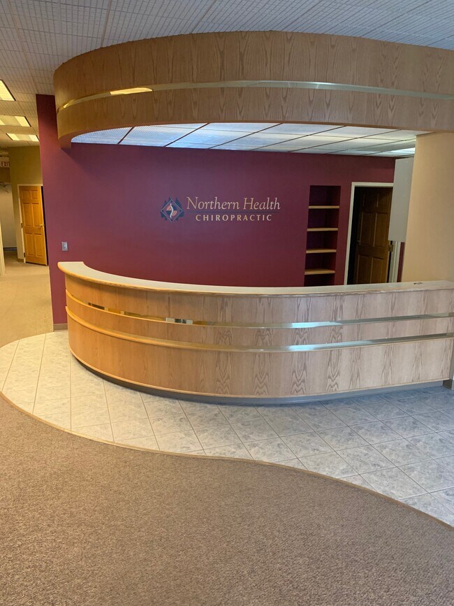
Commercialnec
MARQUETTE
A Areas with a 1% annual chance of flooding and a 26% chance of flooding over the life of a 30-year mortgage.
Michigan
2025
3.62 AC
2025
Upper Peninsula
002100
Other Market Areas
25,648 SF
Marquette, MI
NEARBY LISTINGS FOR SALE OR LEASE
DEMOGRAPHICS near 1330 Us Highway 41 W
1 mile
3 mile
5 mile
2025 Total Population
2,083
9,932
14,352
2030 Population
2,100
9,974
14,412
Pop Growth 2025-2030
+ 0.82%
+ 0.42%
+ 0.42%
Average Age
42
41
41
2025 Total Households
835
4,224
6,089
HH Growth 2025-2030
+ 1.08%
+ 0.62%
+ 0.61%
Median Household Inc
$70,168
$58,521
$61,217
Avg Household Size
2.40
2.30
2.30
2025 Avg HH Vehicles
2.00
2.00
2.00
Median Home Value
$190,971
$155,399
$162,277
Median Year Built
1970
1951
1952
Nearby Places
Map Layers
Map Styles
 Street
 Aerial
Layers
 Traffic
 Biking
Places
Listings with unknown addresses are not visible on the map
- Restaurants
- Banks
- Shops
- Fitness
- Groceries
PUBLIC TRANSPORTATION
AIRPORT
Marquette/Sawyer Regional
Drive
Walk
Distance
Marquette/Sawyer Regional
40 min
23.8 mi
Freight Ports
Port Milwaukee
Drive
Walk
Distance
Port Milwaukee
339 min
279.8 mi
SALE & LEASE HISTORY
LISTING DATE
SALE/LEASE

Sep 27, 2018
For Lease
Jun 30, 2017
For Lease
Nearby Properties
Address
Land Use
TOTAL SIZE
Lot Size
Zoning
Address
Land Use
TOTAL SIZE
Lot Size
Zoning
Address
Land Use
TOTAL SIZE
Lot Size
Zoning
148,007 SF
40 AC
DD
Address
Land Use
TOTAL SIZE
Lot Size
Zoning
32,858 SF
6.19 AC
B-2
Address
Land Use
TOTAL SIZE
Lot Size
Zoning
40,081 SF
9.17 AC
Address
Land Use
TOTAL SIZE
Lot Size
Zoning
6,724 SF
1.29 AC
GC
Address
Land Use
TOTAL SIZE
Lot Size
Zoning
39,832 SF
15 AC
GC
Address
Land Use
TOTAL SIZE
Lot Size
Zoning
66,472 SF
7.16 AC
MR
Address
Land Use
TOTAL SIZE
Lot Size
Zoning
28,683 SF
2.06 AC
GC
Address
Land Use
TOTAL SIZE
Lot Size
Zoning
50,200 SF
10.60 AC
I
Address
Land Use
TOTAL SIZE
Lot Size
Zoning
41,165 SF
5.50 AC
GC
Address
Land Use
TOTAL SIZE
Lot Size
Zoning
77,680 SF
17.82 AC
I
Address
Land Use
TOTAL SIZE
Lot Size
Zoning
21,099 SF
4.60 AC
I
Address
Land Use
TOTAL SIZE
Lot Size
Zoning
31,075 SF
1 AC
GC
Address
Land Use
TOTAL SIZE
Lot Size
Zoning
18,718 SF
1.70 AC
GC
Address
Land Use
TOTAL SIZE
Lot Size
Zoning
28,280 SF
3.26 AC
MR
Address
Land Use
TOTAL SIZE
Lot Size
Zoning
960 SF
20.40 AC
Address
Land Use
TOTAL SIZE
Lot Size
Zoning
14,680 SF
1.19 AC
Address
Land Use
TOTAL SIZE
Lot Size
Zoning
6,676 SF
0.37 AC
Address
Land Use
TOTAL SIZE
Lot Size
Zoning
41,308 SF
6.90 AC
I
Address
Land Use
TOTAL SIZE
Lot Size
Zoning
9,970 SF
2.12 AC
Address
Land Use
TOTAL SIZE
Lot Size
Zoning
2,947 SF
1.34 AC
GC
Address
Land Use
TOTAL SIZE
Lot Size
Zoning
22,500 SF
3.18 AC
GC
Address
Land Use
TOTAL SIZE
Lot Size
Zoning
5,019 SF
1.50 AC
GC
Address
Land Use
TOTAL SIZE
Lot Size
Zoning
9,272 SF
2.27 AC
Address
Land Use
TOTAL SIZE
Lot Size
Zoning
9,020 SF
3.51 AC
GC
Address
Land Use
TOTAL SIZE
Lot Size
Zoning
2,592 SF
1 AC
GC
Address
Land Use
TOTAL SIZE
Lot Size
Zoning
8,272 SF
0.11 AC
CBD
Address
Land Use
TOTAL SIZE
Lot Size
Zoning
16,916 SF
GC
The World's #1 Commercial Real Estate Marketplace
Connect with us
© 2026 CoStar Group
The information above has been obtained from sources believed reliable. While we do not doubt its accuracy we have not verified it and make no guarantee, warranty or representation about it. It is your responsibility to independently confirm its accuracy and completeness. Any projections, opinions, assumptions, or estimates used are for example only and do not represent the current or future performance of the property. The value of this transaction to you depends on tax and other factors which should be evaluated by your tax, financial, and legal advisors. You and your advisors should conduct a careful, independent investigation of the property to determine to your satisfaction the suitability of the property for your needs.