Property Record
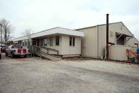
1330 W Grove Rd, Decatur, IL 62521

NEARBY LISTINGS FOR SALE OR LEASE
-
-
View all Decatur listings for lease on LoopNet.com
Property Detail
1330 W Grove Rd
17-12-28-451-012
Contract For Deed
Commercialnec
EXC N 100) S ~600 OF E 10 ACS ~SW 1/4 SE 1/4 & W 1 1/2 CHS ~SE 1/4 SE 1/4 ~58 17 1 01 0453 000 00 ~95BK2622/670 03BK3316/608
X
Macon
17115C0315E
Illinois
2024
5.07 AC
2024
Other Market Areas
002601
Decatur, IL
DEMOGRAPHICS near 1330 W Grove Rd
1 Mile
3 Mile
5 Mile
2024 Total Population
1,766
21,713
57,739
2029 Population
1,710
21,265
56,604
Pop Growth 2024-2029
(3.17%)
(2.06%)
(1.97%)
Average Age
48
41
40
2024 Total Households
790
9,138
24,874
HH Growth 2024-2029
(3.16%)
(2.02%)
(2.05%)
Median Household Inc
$82,049
$45,565
$42,918
Avg Household Size
2.20
2.20
2.20
2024 Avg HH Vehicles
2.00
2.00
2.00
Median Home Value
$150,000
$105,787
$89,563
Median Year Built
1968
1956
1957
Nearby Places
Map Layers
Map Styles
 Street
 Aerial
- Restaurants
- Banks
- Shops
- Fitness
- Groceries
SALE & LEASE HISTORY
LISTING DATE
SALE/LEASE

Sep 25, 2016
For Lease
Nearby Properties
Address
Land Use
TOTAL SIZE
Lot Size
Zoning
Address
Land Use
TOTAL SIZE
Lot Size
Zoning
8.48 AC
MUNICIPAL
Address
Land Use
TOTAL SIZE
Lot Size
Zoning
7.82 AC
MUNICIPAL
Address
Land Use
TOTAL SIZE
Lot Size
Zoning
1.72 AC
MUNICIPAL
Address
Land Use
TOTAL SIZE
Lot Size
Zoning
1.10 AC
MUNICIPAL
Address
Land Use
TOTAL SIZE
Lot Size
Zoning
14.33 AC
MUNICIPAL
Address
Land Use
TOTAL SIZE
Lot Size
Zoning
4.30 AC
MUNICIPAL
Address
Land Use
TOTAL SIZE
Lot Size
Zoning
2.62 AC
MUNICIPAL
Address
Land Use
TOTAL SIZE
Lot Size
Zoning
1 AC
MUNICIPAL
Address
Land Use
TOTAL SIZE
Lot Size
Zoning
4.38 AC
MUNICIPAL
Address
Land Use
TOTAL SIZE
Lot Size
Zoning
2.50 AC
MUNICIPAL
Address
Land Use
TOTAL SIZE
Lot Size
Zoning
3.54 AC
MUNICIPAL
Address
Land Use
TOTAL SIZE
Lot Size
Zoning
13.97 AC
MUNICIPAL
Address
Land Use
TOTAL SIZE
Lot Size
Zoning
0.45 AC
MUNICIPAL
Address
Land Use
TOTAL SIZE
Lot Size
Zoning
0.55 AC
MUNICIPAL
Address
Land Use
TOTAL SIZE
Lot Size
Zoning
0.72 AC
MUNICIPAL
Address
Land Use
TOTAL SIZE
Lot Size
Zoning
2,828 SF
1.07 AC
MUNICIPAL
Address
Land Use
TOTAL SIZE
Lot Size
Zoning
1.93 AC
MUNICIPAL
Address
Land Use
TOTAL SIZE
Lot Size
Zoning
1.94 AC
MUNICIPAL
Address
Land Use
TOTAL SIZE
Lot Size
Zoning
3.93 AC
MUNICIPAL
Address
Land Use
TOTAL SIZE
Lot Size
Zoning
1.22 AC
MUNICIPAL
Address
Land Use
TOTAL SIZE
Lot Size
Zoning
0.73 AC
MUNICIPAL
Address
Land Use
TOTAL SIZE
Lot Size
Zoning
1.54 AC
MUNICIPAL
Address
Land Use
TOTAL SIZE
Lot Size
Zoning
2.13 AC
MUNICIPAL
Address
Land Use
TOTAL SIZE
Lot Size
Zoning
2.76 AC
MUNICIPAL
Address
Land Use
TOTAL SIZE
Lot Size
Zoning
7.96 AC
MUNICIPAL
Address
Land Use
TOTAL SIZE
Lot Size
Zoning
0.53 AC
MUNICIPAL
Address
Land Use
TOTAL SIZE
Lot Size
Zoning
5.59 AC
MUNICIPAL
Address
Land Use
TOTAL SIZE
Lot Size
Zoning
9,240 SF
0.49 AC
MUNICIPAL
The World's #1 Commercial Real Estate Marketplace
Connect with us
© 2026 CoStar Group
The information above has been obtained from sources believed reliable. While we do not doubt its accuracy we have not verified it and make no guarantee, warranty or representation about it. It is your responsibility to independently confirm its accuracy and completeness. Any projections, opinions, assumptions, or estimates used are for example only and do not represent the current or future performance of the property. The value of this transaction to you depends on tax and other factors which should be evaluated by your tax, financial, and legal advisors. You and your advisors should conduct a careful, independent investigation of the property to determine to your satisfaction the suitability of the property for your needs.