Property Record
13300 Long Fisher Rd, North Little Rock, AR 72113
Current Lease Availabilities
NEARBY LISTINGS FOR SALE OR LEASE
-
-
View all North Little Rock listings for lease on LoopNet.com
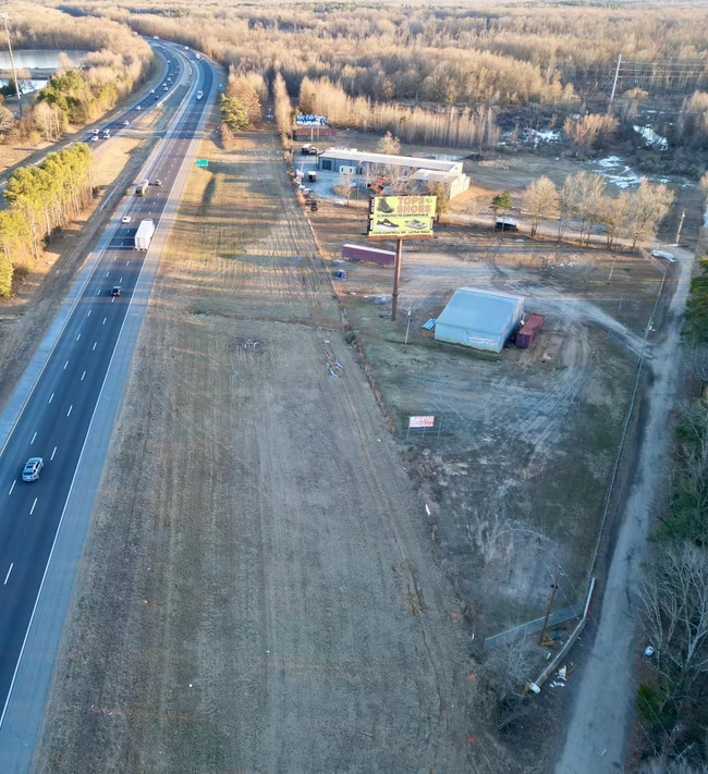
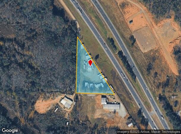
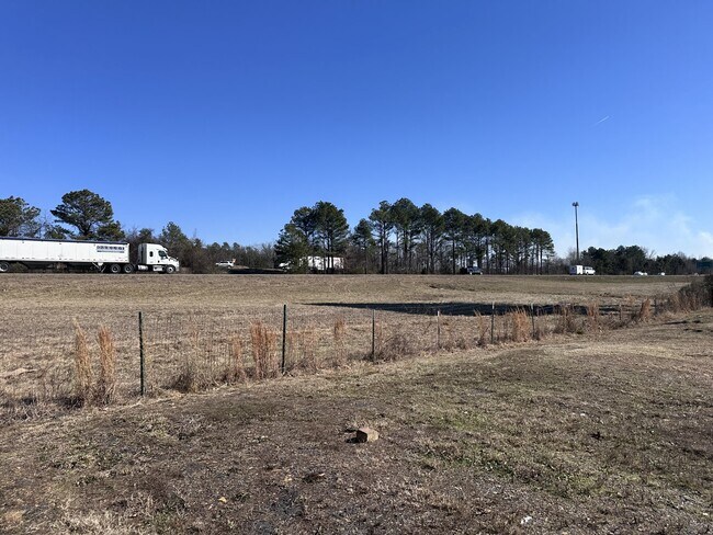
Property Detail
13300 Long Fisher Rd
42Q-023-00-068-00
IMPROVEMENTS ONLY BILLBOARDS (4) @ LAT/LONG 34.876474-92.372102 SITS ON 42R-023.00-068.00 PT NW SW BEG SW COR N056E600.1 S32*59E734.5 N87*45W410.5 TO POB 23 3N 13W
Commercialnec
Pulaski
X
Arkansas
05119C0145G
42r-0
2025
Outlying Pulaski County
2025
Little Rock/N Little Rock
004309
Little Rock-North Little Rock-Conway, AR
DEMOGRAPHICS near 13300 Long Fisher Rd
1 Mile
3 Mile
5 Mile
2024 Total Population
1,039
19,617
30,022
2029 Population
1,032
19,445
29,762
Pop Growth 2024-2029
(0.67%)
(0.88%)
(0.87%)
Average Age
40
39
39
2024 Total Households
426
8,557
13,001
HH Growth 2024-2029
(0.70%)
(0.85%)
(0.85%)
Median Household Inc
$47,500
$63,483
$66,516
Avg Household Size
2.40
2.30
2.30
2024 Avg HH Vehicles
2.00
2.00
2.00
Median Home Value
$153,389
$193,013
$223,234
Median Year Built
1999
1999
1999
Nearby Places
- Restaurants
- Banks
- Shops
- Fitness
- Groceries
PUBLIC TRANSPORTATION
AIRPORT
Bill and Hillary Clinton Ntl/Adams Field
DRIVE
WALK
Distance
Bill and Hillary Clinton Ntl/Adams Field
25 min
18.6 mi
Freight Ports
Port of Shreveport
DRIVE
WALK
Distance
Port of Shreveport
260 min
240.9 mi
Nearby Properties
Address
Land Use
TOTAL SIZE
Lot Size
Zoning
Address
Land Use
TOTAL SIZE
Lot Size
Zoning
1,160,360 SF
119.55 AC
Address
Land Use
TOTAL SIZE
Lot Size
Zoning
320,000 SF
91.54 AC
Address
Land Use
TOTAL SIZE
Lot Size
Zoning
89,847 SF
12.77 AC
Address
Land Use
TOTAL SIZE
Lot Size
Zoning
35,712 SF
19.92 AC
Address
Land Use
TOTAL SIZE
Lot Size
Zoning
55,997 SF
11.51 AC
Address
Land Use
TOTAL SIZE
Lot Size
Zoning
83,352 SF
6.90 AC
Address
Land Use
TOTAL SIZE
Lot Size
Zoning
77,478 SF
38.22 AC
Address
Land Use
TOTAL SIZE
Lot Size
Zoning
12,077 SF
27.97 AC
Address
Land Use
TOTAL SIZE
Lot Size
Zoning
484,932 SF
32.85 AC
Address
Land Use
TOTAL SIZE
Lot Size
Zoning
157,500 SF
54.99 AC
Address
Land Use
TOTAL SIZE
Lot Size
Zoning
2,340 SF
37.56 AC
Address
Land Use
TOTAL SIZE
Lot Size
Zoning
192,104 SF
34.51 AC
Address
Land Use
TOTAL SIZE
Lot Size
Zoning
139,444 SF
7.63 AC
Address
Land Use
TOTAL SIZE
Lot Size
Zoning
8,624 SF
10.37 AC
Address
Land Use
TOTAL SIZE
Lot Size
Zoning
66,619 SF
5.89 AC
Address
Land Use
TOTAL SIZE
Lot Size
Zoning
56,423 SF
Address
Land Use
TOTAL SIZE
Lot Size
Zoning
8,417 SF
101 AC
Address
Land Use
TOTAL SIZE
Lot Size
Zoning
12,346 SF
14.41 AC
Address
Land Use
TOTAL SIZE
Lot Size
Zoning
38,369 SF
10.04 AC
Address
Land Use
TOTAL SIZE
Lot Size
Zoning
60,966 SF
21.82 AC
Address
Land Use
TOTAL SIZE
Lot Size
Zoning
6,357 SF
10.80 AC
Address
Land Use
TOTAL SIZE
Lot Size
Zoning
37,955 SF
2.45 AC
Address
Land Use
TOTAL SIZE
Lot Size
Zoning
840 SF
20.01 AC
Address
Land Use
TOTAL SIZE
Lot Size
Zoning
83,647 SF
11.60 AC
Address
Land Use
TOTAL SIZE
Lot Size
Zoning
71,132 SF
5.89 AC
Address
Land Use
TOTAL SIZE
Lot Size
Zoning
162,010 SF
10.45 AC
Address
Land Use
TOTAL SIZE
Lot Size
Zoning
90,746 SF
5.84 AC
Address
Land Use
TOTAL SIZE
Lot Size
Zoning
31,220 SF
2.29 AC
Address
Land Use
TOTAL SIZE
Lot Size
Zoning
68,304 SF
4.18 AC
Address
Land Use
TOTAL SIZE
Lot Size
Zoning
29,599 SF
6.06 AC
The World's #1 Commercial Real Estate Marketplace
Connect with us
© 2025 CoStar Group
The information above has been obtained from sources believed reliable. While we do not doubt its accuracy we have not verified it and make no guarantee, warranty or representation about it. It is your responsibility to independently confirm its accuracy and completeness. Any projections, opinions, assumptions, or estimates used are for example only and do not represent the current or future performance of the property. The value of this transaction to you depends on tax and other factors which should be evaluated by your tax, financial, and legal advisors. You and your advisors should conduct a careful, independent investigation of the property to determine to your satisfaction the suitability of the property for your needs.