Property Record
13306 Boyette Rd, Riverview, FL 33569

Property Detail
13306 Boyette Rd
U-23-30-20-ZZZ-000003-03530.3
THAT PART OF NE 1/4 OF SE 1/4 DESC AS COMM AT SE COR OF NE 1/4 OF SE 1/4 RUN S 89 DEG 45 MIN 44 SEC W 934.77 FT THN N 00 DEG 02 MIN 19 SEC W 38.61 FT TO N R/W LINE OF BOYETTE RD TO POB THN N 00 DEG 02 MIN 19 SEC W 490.32 FT THN S 89 DEG 47 MIN 43 SEC
Privateschool
HILLSBOROUGH
PD
Florida
AE The base floodplain where base flood elevations are provided. AE Zones are now used on new format FIRMs instead of A1-A30 Zones.
3530
2024
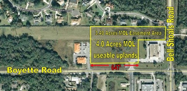
7.10 AC
2025
East Tampa
013413
Tampa/St Petersburg
61,120 SF
Tampa-St. Petersburg-Clearwater, FL
NEARBY LISTINGS FOR SALE OR LEASE
DEMOGRAPHICS near 13306 Boyette Rd
1 mile
3 mile
5 mile
2025 Total Population
6,587
62,165
194,490
2030 Population
7,050
67,001
209,715
Pop Growth 2025-2030
+ 7.03%
+ 7.78%
+ 7.83%
Average Age
39
40
39
2025 Total Households
2,075
20,923
67,153
HH Growth 2025-2030
+ 7.23%
+ 7.90%
+ 7.96%
Median Household Inc
$116,037
$109,043
$103,635
Avg Household Size
3.10
2.90
2.80
2025 Avg HH Vehicles
2.00
2.00
2.00
Median Home Value
$447,017
$441,818
$426,691
Median Year Built
2000
1998
2001
Nearby Places
Map Layers
Map Styles
 Street
 Aerial
Transit
 Traffic
 Biking
Places
Listings with unknown addresses are not visible on the map
- Restaurants
- Banks
- Shops
- Fitness
- Groceries
PUBLIC TRANSPORTATION
AIRPORT
Tampa International
Drive
Walk
Distance
Tampa International
40 min
25.3 mi
St Pete-Clearwater International
Drive
Walk
Distance
St Pete-Clearwater International
57 min
34.5 mi
Freight Ports
Port of Tampa Bay
Drive
Walk
Distance
Port of Tampa Bay
27 min
15.3 mi
Nearby Properties
Address
Land Use
TOTAL SIZE
Lot Size
Zoning
Address
Land Use
TOTAL SIZE
Lot Size
Zoning
361,294 SF
10.35 AC
PD
Address
Land Use
TOTAL SIZE
Lot Size
Zoning
288,270 SF
78.75 AC
PD
Address
Land Use
TOTAL SIZE
Lot Size
Zoning
231,811 SF
26.54 AC
PD
Address
Land Use
TOTAL SIZE
Lot Size
Zoning
289,109 SF
75.56 AC
AR
Address
Land Use
TOTAL SIZE
Lot Size
Zoning
182,688 SF
14.69 AC
PD
Address
Land Use
TOTAL SIZE
Lot Size
Zoning
190,080 SF
22.45 AC
PD
Address
Land Use
TOTAL SIZE
Lot Size
Zoning
113,134 SF
7.96 AC
PD
Address
Land Use
TOTAL SIZE
Lot Size
Zoning
870.14 AC
AR
Address
Land Use
TOTAL SIZE
Lot Size
Zoning
190.14 AC
PD
Address
Land Use
TOTAL SIZE
Lot Size
Zoning
73,541 SF
10.22 AC
AR
Address
Land Use
TOTAL SIZE
Lot Size
Zoning
57,438 SF
12.28 AC
PD
Address
Land Use
TOTAL SIZE
Lot Size
Zoning
163,701 SF
87.66 AC
PD
Address
Land Use
TOTAL SIZE
Lot Size
Zoning
97,039 SF
35.42 AC
PD
Address
Land Use
TOTAL SIZE
Lot Size
Zoning
104,130 SF
19.71 AC
PD
Address
Land Use
TOTAL SIZE
Lot Size
Zoning
96,158 SF
11.98 AC
PD
Address
Land Use
TOTAL SIZE
Lot Size
Zoning
110,461 SF
5.72 AC
PD
Address
Land Use
TOTAL SIZE
Lot Size
Zoning
97,587 SF
24.06 AC
PD
Address
Land Use
TOTAL SIZE
Lot Size
Zoning
89,725 SF
23.64 AC
PD
Address
Land Use
TOTAL SIZE
Lot Size
Zoning
82,340 SF
11.12 AC
PD
Address
Land Use
TOTAL SIZE
Lot Size
Zoning
69,591 SF
38.33 AC
PD
Address
Land Use
TOTAL SIZE
Lot Size
Zoning
71,818 SF
13.94 AC
PD
Address
Land Use
TOTAL SIZE
Lot Size
Zoning
68,422 SF
9.14 AC
PD
Address
Land Use
TOTAL SIZE
Lot Size
Zoning
60,984 SF
11.30 AC
PD
Address
Land Use
TOTAL SIZE
Lot Size
Zoning
76,308 SF
5.80 AC
PD
Address
Land Use
TOTAL SIZE
Lot Size
Zoning
36,254 SF
3.48 AC
PD
Address
Land Use
TOTAL SIZE
Lot Size
Zoning
54,698 SF
7.30 AC
PD
Address
Land Use
TOTAL SIZE
Lot Size
Zoning
93,043 SF
9.46 AC
PD
Address
Land Use
TOTAL SIZE
Lot Size
Zoning
73,245 SF
4.37 AC
PD
Address
Land Use
TOTAL SIZE
Lot Size
Zoning
33,867 SF
5.56 AC
PD
The World's #1 Commercial Real Estate Marketplace
Connect with us
© 2026 CoStar Group
The information above has been obtained from sources believed reliable. While we do not doubt its accuracy we have not verified it and make no guarantee, warranty or representation about it. It is your responsibility to independently confirm its accuracy and completeness. Any projections, opinions, assumptions, or estimates used are for example only and do not represent the current or future performance of the property. The value of this transaction to you depends on tax and other factors which should be evaluated by your tax, financial, and legal advisors. You and your advisors should conduct a careful, independent investigation of the property to determine to your satisfaction the suitability of the property for your needs.