Property Record
13310 New Hampshire Ave, Silver Spring, MD 20904
NEARBY LISTINGS FOR SALE OR LEASE
-
-
View all Silver Spring listings for sale on LoopNet.com
Property Detail
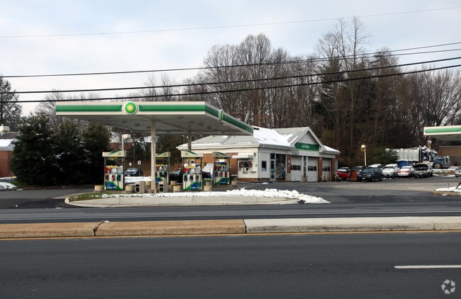
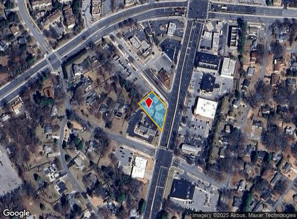
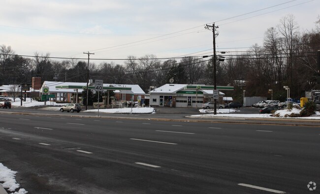
13310 New Hampshire Ave
Washington-Arlington-Alexandria, DC-VA-MD-WV
Bealls Manor
05-00261845
PLAT 9275 ACORNS ADD TO COLESVILLE
Servicestation
Montgomery
X
Maryland
24031C0360D
19
2024
0.45 AC
2025
North Silver Spring/Rt 29
701506
Washington, DC
1,827 SF
DEMOGRAPHICS near 13310 New Hampshire Ave
1 Mile
3 Mile
5 Mile
2024 Total Population
9,647
93,989
315,798
2029 Population
9,547
92,647
311,330
Pop Growth 2024-2029
(1.04%)
(1.43%)
(1.41%)
Average Age
45
41
41
2024 Total Households
3,100
30,971
107,395
HH Growth 2024-2029
(1.23%)
(1.60%)
(1.46%)
Median Household Inc
$126,334
$104,567
$98,112
Avg Household Size
2.90
2.90
2.80
2024 Avg HH Vehicles
2.00
2.00
2.00
Median Home Value
$564,143
$523,296
$461,385
Median Year Built
1968
1975
1972
Nearby Places
Map Layers
Map Styles
 Street
 Aerial
- Restaurants
- Banks
- Shops
- Fitness
- Groceries
PUBLIC TRANSPORTATION
COMMUTER RAIL
Kensington (BRUNSWICK - WASHINGTON - Maryland Area Regional Commuter Trains (The MARC), Brunswick Line - Maryland Area Regional Commuter Trains (The MARC))
DRIVE
WALK
Distance
Kensington (BRUNSWICK - WASHINGTON - Maryland Area Regional Commuter Trains (The MARC), Brunswick Line - Maryland Area Regional Commuter Trains (The MARC))
11 min
6.6 mi
Garrett Park (BRUNSWICK - WASHINGTON - Maryland Area Regional Commuter Trains (The MARC), Brunswick Line - Maryland Area Regional Commuter Trains (The MARC))
DRIVE
WALK
Distance
Garrett Park (BRUNSWICK - WASHINGTON - Maryland Area Regional Commuter Trains (The MARC), Brunswick Line - Maryland Area Regional Commuter Trains (The MARC))
15 min
7.8 mi
AIRPORT
Ronald Reagan Washington Ntl
DRIVE
WALK
Distance
Ronald Reagan Washington Ntl
32 min
18.0 mi
Baltimore/Washington International Thurgood Marshall
DRIVE
WALK
Distance
Baltimore/Washington International Thurgood Marshall
36 min
27.3 mi
Washington Dulles International
DRIVE
WALK
Distance
Washington Dulles International
53 min
34.1 mi
Freight Ports
Port of Baltimore
DRIVE
WALK
Distance
Port of Baltimore
40 min
30.2 mi
Nearby Properties
Address
Land Use
TOTAL SIZE
Lot Size
Zoning
Address
Land Use
TOTAL SIZE
Lot Size
Zoning
456,429 SF
35.07 AC
I3
Address
Land Use
TOTAL SIZE
Lot Size
Zoning
610.61 AC
RE2
Address
Land Use
TOTAL SIZE
Lot Size
Zoning
917,092 SF
17.19 AC
R10
Address
Land Use
TOTAL SIZE
Lot Size
Zoning
66,150 SF
6.79 AC
CRF
Address
Land Use
TOTAL SIZE
Lot Size
Zoning
458,546 SF
8.56 AC
R10
Address
Land Use
TOTAL SIZE
Lot Size
Zoning
385,000 SF
16.42 AC
RH
Address
Land Use
TOTAL SIZE
Lot Size
Zoning
164,307 SF
16.45 AC
R90
Address
Land Use
TOTAL SIZE
Lot Size
Zoning
251,862 SF
91.09 AC
RE2C
Address
Land Use
TOTAL SIZE
Lot Size
Zoning
540,807 SF
8.73 AC
RH
Address
Land Use
TOTAL SIZE
Lot Size
Zoning
371,939 SF
21.54 AC
EOF1.
Address
Land Use
TOTAL SIZE
Lot Size
Zoning
427,500 SF
25.70 AC
R30
Address
Land Use
TOTAL SIZE
Lot Size
Zoning
215,937 SF
2.91 AC
CR2.0
Address
Land Use
TOTAL SIZE
Lot Size
Zoning
170,619 SF
11.49 AC
R20
Address
Land Use
TOTAL SIZE
Lot Size
Zoning
321,840 SF
13.95 AC
R20
Address
Land Use
TOTAL SIZE
Lot Size
Zoning
545,265 SF
9.51 AC
R10
Address
Land Use
TOTAL SIZE
Lot Size
Zoning
220,730 SF
13.11 AC
R20
Address
Land Use
TOTAL SIZE
Lot Size
Zoning
92,294 SF
3.22 AC
CR0.7
Address
Land Use
TOTAL SIZE
Lot Size
Zoning
291,413 SF
12.07 AC
R20
Address
Land Use
TOTAL SIZE
Lot Size
Zoning
332,133 SF
28.24 AC
R90
Address
Land Use
TOTAL SIZE
Lot Size
Zoning
254,416 SF
24.98 AC
CR1.0
Address
Land Use
TOTAL SIZE
Lot Size
Zoning
350,684 SF
36.50 AC
EOF1.
Address
Land Use
TOTAL SIZE
Lot Size
Zoning
303,542 SF
25.13 AC
R200
Address
Land Use
TOTAL SIZE
Lot Size
Zoning
387,943 SF
8.91 AC
R60
Address
Land Use
TOTAL SIZE
Lot Size
Zoning
74,243 SF
5.48 AC
NR0.7
Address
Land Use
TOTAL SIZE
Lot Size
Zoning
118,204 SF
8.62 AC
NR0.7
Address
Land Use
TOTAL SIZE
Lot Size
Zoning
165,756 SF
8.76 AC
R20
Address
Land Use
TOTAL SIZE
Lot Size
Zoning
220,320 SF
14.36 AC
R30
Address
Land Use
TOTAL SIZE
Lot Size
Zoning
177,712 SF
13.89 AC
GR1.5
Address
Land Use
TOTAL SIZE
Lot Size
Zoning
110.92 AC
CR1.0
Address
Land Use
TOTAL SIZE
Lot Size
Zoning
140,990 SF
17.34 AC
R90
The World's #1 Commercial Real Estate Marketplace
Connect with us
© 2025 CoStar Group
The information above has been obtained from sources believed reliable. While we do not doubt its accuracy we have not verified it and make no guarantee, warranty or representation about it. It is your responsibility to independently confirm its accuracy and completeness. Any projections, opinions, assumptions, or estimates used are for example only and do not represent the current or future performance of the property. The value of this transaction to you depends on tax and other factors which should be evaluated by your tax, financial, and legal advisors. You and your advisors should conduct a careful, independent investigation of the property to determine to your satisfaction the suitability of the property for your needs.