Property Record
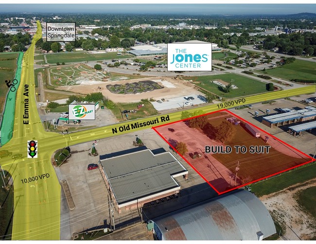
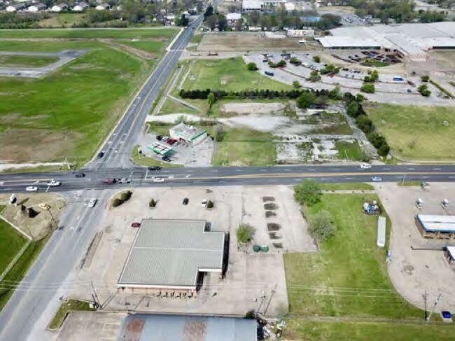
1332 E Emma Ave, Springdale, AR 72764

Property Detail
1332 E Emma Ave
Fayetteville-Springdale-Rogers, AR
PT LOT 11 S1/2 NE SW
815-27578-000
WASHINGTON
Liquorstore
Arkansas
B and X Area of moderate flood hazard, usually the area between the limits of the 100-year and 500-year floods.
11
2025
0.78 AC
2025
Greater Springdale
010307
Fayetteville/Springdale/Rogers
7,010 SF
NEARBY LISTINGS FOR SALE OR LEASE
DEMOGRAPHICS near 1332 E Emma Ave
1 mile
3 mile
5 mile
2025 Total Population
9,885
65,291
106,495
2030 Population
10,547
69,794
114,145
Pop Growth 2025-2030
+ 6.70%
+ 6.90%
+ 7.18%
Average Age
32
34
36
2025 Total Households
2,891
19,958
35,622
HH Growth 2025-2030
+ 6.85%
+ 7.02%
+ 7.33%
Median Household Inc
$47,112
$60,775
$69,414
Avg Household Size
3.30
3.10
2.90
2025 Avg HH Vehicles
2.00
2.00
2.00
Median Home Value
$182,579
$243,196
$281,048
Median Year Built
1993
1992
1995
Nearby Places
Map Layers
Map Styles
 Street
 Aerial
Layers
 Traffic
 Biking
Places
Listings with unknown addresses are not visible on the map
- Restaurants
- Banks
- Shops
- Fitness
- Groceries
PUBLIC TRANSPORTATION
AIRPORT
Northwest Arkansas Ntl
Drive
Walk
Distance
Northwest Arkansas Ntl
35 min
18.1 mi
Freight Ports
Tulsa Port of Inola
Drive
Walk
Distance
Tulsa Port of Inola
106 min
89.2 mi
SALE & LEASE HISTORY
LISTING DATE
SALE/LEASE

Sep 05, 2018
For Lease
Nearby Properties
Address
Land Use
TOTAL SIZE
Lot Size
Zoning
Address
Land Use
TOTAL SIZE
Lot Size
Zoning
167,116 SF
41.39 AC
I1
Address
Land Use
TOTAL SIZE
Lot Size
Zoning
58,764 SF
1.56 AC
Address
Land Use
TOTAL SIZE
Lot Size
Zoning
403,089 SF
1.93 AC
Address
Land Use
TOTAL SIZE
Lot Size
Zoning
481,800 SF
40 AC
Address
Land Use
TOTAL SIZE
Lot Size
Zoning
153,718 SF
Address
Land Use
TOTAL SIZE
Lot Size
Zoning
341,266 SF
17.61 AC
Address
Land Use
TOTAL SIZE
Lot Size
Zoning
117,690 SF
2.38 AC
Address
Land Use
TOTAL SIZE
Lot Size
Zoning
4,941 SF
10.87 AC
Address
Land Use
TOTAL SIZE
Lot Size
Zoning
174,333 SF
25 AC
I1I2
Address
Land Use
TOTAL SIZE
Lot Size
Zoning
134,342 SF
14.95 AC
Address
Land Use
TOTAL SIZE
Lot Size
Zoning
156,072 SF
12.43 AC
Address
Land Use
TOTAL SIZE
Lot Size
Zoning
16,698 SF
1.11 AC
Address
Land Use
TOTAL SIZE
Lot Size
Zoning
178,140 SF
4.39 AC
Address
Land Use
TOTAL SIZE
Lot Size
Zoning
180,412 SF
13.14 AC
Address
Land Use
TOTAL SIZE
Lot Size
Zoning
117,196 SF
9.74 AC
Address
Land Use
TOTAL SIZE
Lot Size
Zoning
224,408 SF
9.80 AC
I1
Address
Land Use
TOTAL SIZE
Lot Size
Zoning
73,436 SF
16.01 AC
I1
Address
Land Use
TOTAL SIZE
Lot Size
Zoning
206,446 SF
17.14 AC
Address
Land Use
TOTAL SIZE
Lot Size
Zoning
116,736 SF
10.95 AC
Address
Land Use
TOTAL SIZE
Lot Size
Zoning
177,864 SF
18.04 AC
Address
Land Use
TOTAL SIZE
Lot Size
Zoning
80,475 SF
0.45 AC
C3
Address
Land Use
TOTAL SIZE
Lot Size
Zoning
73,711 SF
3.59 AC
Address
Land Use
TOTAL SIZE
Lot Size
Zoning
147,762 SF
Address
Land Use
TOTAL SIZE
Lot Size
Zoning
74,434 SF
32.25 AC
Address
Land Use
TOTAL SIZE
Lot Size
Zoning
46,701 SF
4.10 AC
Address
Land Use
TOTAL SIZE
Lot Size
Zoning
352,195 SF
15 AC
Address
Land Use
TOTAL SIZE
Lot Size
Zoning
107,950 SF
6.68 AC
C2
Address
Land Use
TOTAL SIZE
Lot Size
Zoning
54,460 SF
6.38 AC
Address
Land Use
TOTAL SIZE
Lot Size
Zoning
153,968 SF
21 AC
Address
Land Use
TOTAL SIZE
Lot Size
Zoning
364,696 SF
4.49 AC
The World's #1 Commercial Real Estate Marketplace
Connect with us
© 2026 CoStar Group
The information above has been obtained from sources believed reliable. While we do not doubt its accuracy we have not verified it and make no guarantee, warranty or representation about it. It is your responsibility to independently confirm its accuracy and completeness. Any projections, opinions, assumptions, or estimates used are for example only and do not represent the current or future performance of the property. The value of this transaction to you depends on tax and other factors which should be evaluated by your tax, financial, and legal advisors. You and your advisors should conduct a careful, independent investigation of the property to determine to your satisfaction the suitability of the property for your needs.