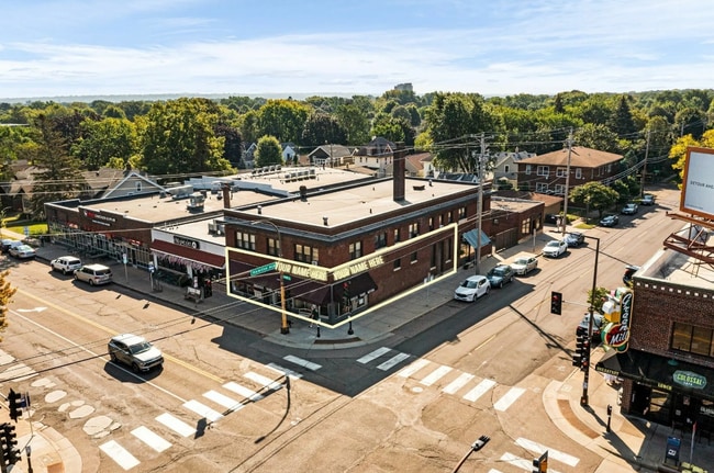
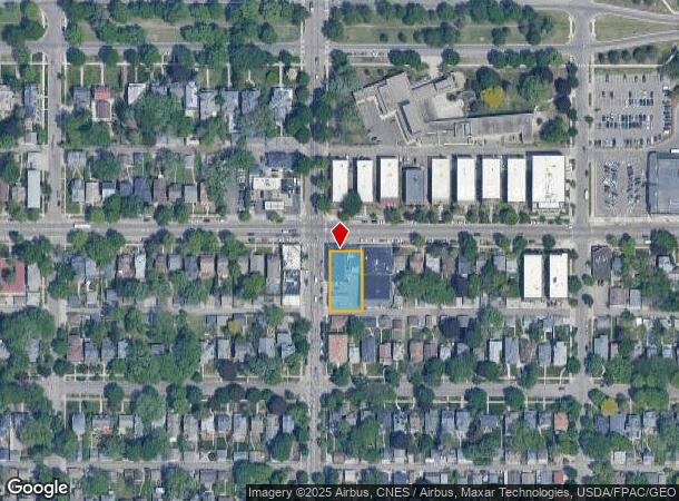
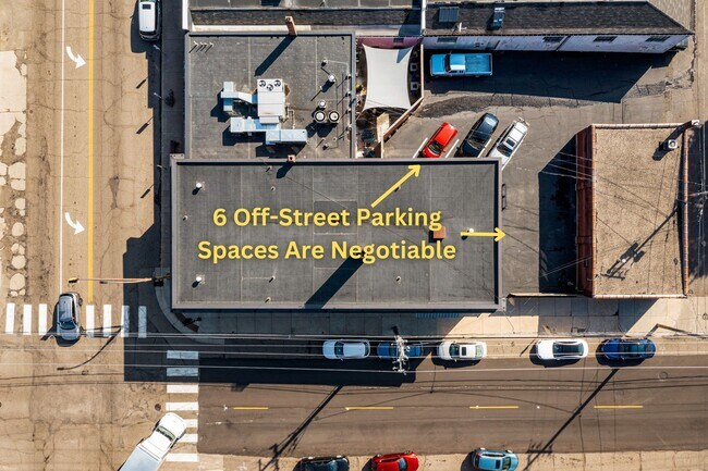
Property Record
1332 Grand Ave, Saint Paul, MN 55105
NEARBY LISTINGS FOR SALE OR LEASE
Property Detail
1332 Grand Ave
Minneapolis/St Paul
Stinsons Boulevard
Minneapolis-St. Paul-Bloomington, MN-WI
STINSONS BOULEVARD LOT 14 AND LOT 15 BLK 3
03-28-23-42-0116
Ramsey
Commercialnec
Minnesota
2024
14,15
2025
0.28 AC
035300
St Paul
DEMOGRAPHICS near 1332 Grand Ave
1 Mile
3 Mile
5 Mile
2024 Total Population
23,515
154,154
386,317
2029 Population
22,946
150,677
378,915
Pop Growth 2024-2029
(2.42%)
(2.26%)
(1.92%)
Average Age
38
39
37
2024 Total Households
10,040
66,730
158,922
HH Growth 2024-2029
(2.78%)
(2.36%)
(1.99%)
Median Household Inc
$86,660
$71,134
$67,219
Avg Household Size
2.10
2.10
2.20
2024 Avg HH Vehicles
2.00
2.00
1.00
Median Home Value
$389,465
$342,197
$305,626
Median Year Built
1946
1948
1954
Nearby Places
Map Layers
Map Styles
 Street
 Aerial
- Restaurants
- Banks
- Shops
- Fitness
- Groceries
PUBLIC TRANSPORTATION
COMMUTER RAIL
DRIVE
WALK
Distance
7 min
3.8 mi
Target Field Station (Northstar Corridor - Northstar Commuter Rail)
DRIVE
WALK
Distance
Target Field Station (Northstar Corridor - Northstar Commuter Rail)
17 min
7.9 mi
AIRPORT
Minneapolis-St Paul International/Wold-Chamberlain
DRIVE
WALK
Distance
Minneapolis-St Paul International/Wold-Chamberlain
14 min
7.3 mi
SALE & LEASE HISTORY
LISTING DATE
SALE/LEASE

Sep 24, 2024
For Lease
Nearby Properties
Address
Land Use
TOTAL SIZE
Lot Size
Zoning
Address
Land Use
TOTAL SIZE
Lot Size
Zoning
141,277 SF
44.78 AC
Address
Land Use
TOTAL SIZE
Lot Size
Zoning
84,316 SF
40.83 AC
Address
Land Use
TOTAL SIZE
Lot Size
Zoning
504,049 SF
75.43 AC
Address
Land Use
TOTAL SIZE
Lot Size
Zoning
582,896 SF
14 AC
Address
Land Use
TOTAL SIZE
Lot Size
Zoning
825,463 SF
7.04 AC
Address
Land Use
TOTAL SIZE
Lot Size
Zoning
124,932 SF
9.68 AC
Address
Land Use
TOTAL SIZE
Lot Size
Zoning
63.12 AC
Address
Land Use
TOTAL SIZE
Lot Size
Zoning
646,900 SF
7.66 AC
Address
Land Use
TOTAL SIZE
Lot Size
Zoning
176,108 SF
27.45 AC
Address
Land Use
TOTAL SIZE
Lot Size
Zoning
32,854 SF
5.55 AC
Address
Land Use
TOTAL SIZE
Lot Size
Zoning
18.24 AC
Address
Land Use
TOTAL SIZE
Lot Size
Zoning
2.65 AC
Address
Land Use
TOTAL SIZE
Lot Size
Zoning
267,530 SF
28.60 AC
Address
Land Use
TOTAL SIZE
Lot Size
Zoning
395,419 SF
2.73 AC
Address
Land Use
TOTAL SIZE
Lot Size
Zoning
3,200 SF
0.14 AC
Address
Land Use
TOTAL SIZE
Lot Size
Zoning
516,325 SF
16.81 AC
Address
Land Use
TOTAL SIZE
Lot Size
Zoning
7.41 AC
Address
Land Use
TOTAL SIZE
Lot Size
Zoning
4,808 SF
269.81 AC
Address
Land Use
TOTAL SIZE
Lot Size
Zoning
68,748 SF
21.59 AC
Address
Land Use
TOTAL SIZE
Lot Size
Zoning
18,630 SF
22.02 AC
Address
Land Use
TOTAL SIZE
Lot Size
Zoning
518,750 SF
3.58 AC
Address
Land Use
TOTAL SIZE
Lot Size
Zoning
276,144 SF
347.68 AC
Address
Land Use
TOTAL SIZE
Lot Size
Zoning
200,892 SF
3.60 AC
Address
Land Use
TOTAL SIZE
Lot Size
Zoning
173.22 AC
Address
Land Use
TOTAL SIZE
Lot Size
Zoning
260,739 SF
3.04 AC
Address
Land Use
TOTAL SIZE
Lot Size
Zoning
445,437 SF
7.80 AC
Address
Land Use
TOTAL SIZE
Lot Size
Zoning
265,736 SF
6.67 AC
Address
Land Use
TOTAL SIZE
Lot Size
Zoning
455,628 SF
2.81 AC
Address
Land Use
TOTAL SIZE
Lot Size
Zoning
251,619 SF
1.20 AC
Address
Land Use
TOTAL SIZE
Lot Size
Zoning
444,819 SF
0.86 AC
The World's #1 Commercial Real Estate Marketplace
Connect with us
© 2025 CoStar Group
The information above has been obtained from sources believed reliable. While we do not doubt its accuracy we have not verified it and make no guarantee, warranty or representation about it. It is your responsibility to independently confirm its accuracy and completeness. Any projections, opinions, assumptions, or estimates used are for example only and do not represent the current or future performance of the property. The value of this transaction to you depends on tax and other factors which should be evaluated by your tax, financial, and legal advisors. You and your advisors should conduct a careful, independent investigation of the property to determine to your satisfaction the suitability of the property for your needs.