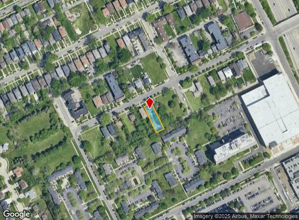
Property Record
1333 Seward St, Detroit, MI 48202
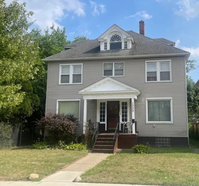
This Property Is For Sale
NEARBY LISTINGS FOR SALE OR LEASE
Property Detail
1333 Seward St
Detroit-Warren-Dearborn, MI
Becks
06-001724
Wayne
Sfr
Michigan
X
0.19 AC
26163C0280E
Detroit W of Woodward
1,904 SF
Detroit
DEMOGRAPHICS near 1333 Seward St
1 Mile
3 Mile
5 Mile
2024 Total Population
18,796
148,796
369,446
2029 Population
19,688
154,081
378,241
Pop Growth 2024-2029
+ 4.75%
+ 3.55%
+ 2.38%
Average Age
40
38
38
2024 Total Households
9,147
62,278
148,817
HH Growth 2024-2029
+ 4.43%
+ 3.91%
+ 2.61%
Median Household Inc
$42,151
$33,771
$37,771
Avg Household Size
2.00
2.20
2.30
2024 Avg HH Vehicles
1.00
1.00
1.00
Median Home Value
$237,019
$108,618
$93,932
Median Year Built
1947
1948
1948
Nearby Places
- Restaurants
- Banks
- Shops
- Fitness
- Groceries
PUBLIC TRANSPORTATION
COMMUTER RAIL
DRIVE
WALK
Distance
4 min
1.3 mi
DRIVE
WALK
Distance
17 min
7.7 mi
AIRPORT
Windsor International
DRIVE
WALK
Distance
Windsor International
30 min
13.7 mi
Detroit Metro Wayne County
DRIVE
WALK
Distance
Detroit Metro Wayne County
33 min
22.1 mi
Freight Ports
DRIVE
WALK
Distance
79 min
62.8 mi
Nearby Properties
Address
Land Use
TOTAL SIZE
Lot Size
Zoning
Address
Land Use
TOTAL SIZE
Lot Size
Zoning
3,032,363 SF
24.24 AC
SD5
Address
Land Use
TOTAL SIZE
Lot Size
Zoning
409,438 SF
0.83 AC
B6
Address
Land Use
TOTAL SIZE
Lot Size
Zoning
1,409,416 SF
13.53 AC
R6
Address
Land Use
TOTAL SIZE
Lot Size
Zoning
873,048 SF
7.70 AC
R6
Address
Land Use
TOTAL SIZE
Lot Size
Zoning
1,017,009 SF
1.35 AC
R6
Address
Land Use
TOTAL SIZE
Lot Size
Zoning
848,598 SF
8.78 AC
SD5
Address
Land Use
TOTAL SIZE
Lot Size
Zoning
252,150 SF
2.46 AC
SD5
Address
Land Use
TOTAL SIZE
Lot Size
Zoning
185,300 SF
3.36 AC
SD5
Address
Land Use
TOTAL SIZE
Lot Size
Zoning
3,793,609 SF
265.70 AC
M4
Address
Land Use
TOTAL SIZE
Lot Size
Zoning
306,496 SF
1.91 AC
R6
Address
Land Use
TOTAL SIZE
Lot Size
Zoning
328,284 SF
768.89 AC
PD
Address
Land Use
TOTAL SIZE
Lot Size
Zoning
268,114 SF
2.46 AC
B6
Address
Land Use
TOTAL SIZE
Lot Size
Zoning
334,904 SF
B5
Address
Land Use
TOTAL SIZE
Lot Size
Zoning
627,489 SF
5.82 AC
B4
Address
Land Use
TOTAL SIZE
Lot Size
Zoning
235,468 SF
1.50 AC
B5
Address
Land Use
TOTAL SIZE
Lot Size
Zoning
210,426 SF
1.97 AC
B4
Address
Land Use
TOTAL SIZE
Lot Size
Zoning
506,450 SF
3.84 AC
B5
Address
Land Use
TOTAL SIZE
Lot Size
Zoning
596,304 SF
2.57 AC
R6
Address
Land Use
TOTAL SIZE
Lot Size
Zoning
221,506 SF
1.51 AC
B4
Address
Land Use
TOTAL SIZE
Lot Size
Zoning
266,016 SF
7.76 AC
PD
Address
Land Use
TOTAL SIZE
Lot Size
Zoning
82,528 SF
6.03 AC
PD
Address
Land Use
TOTAL SIZE
Lot Size
Zoning
420,012 SF
B5
Address
Land Use
TOTAL SIZE
Lot Size
Zoning
475,252 SF
1.74 AC
B4
Address
Land Use
TOTAL SIZE
Lot Size
Zoning
144,000 SF
0.18 AC
B5
Address
Land Use
TOTAL SIZE
Lot Size
Zoning
167,000 SF
1.83 AC
PD
Address
Land Use
TOTAL SIZE
Lot Size
Zoning
332,208 SF
2.72 AC
R6
Address
Land Use
TOTAL SIZE
Lot Size
Zoning
153,764 SF
B4
Address
Land Use
TOTAL SIZE
Lot Size
Zoning
274,013 SF
2.42 AC
B4
Address
Land Use
TOTAL SIZE
Lot Size
Zoning
302,215 SF
2.67 AC
B5
Address
Land Use
TOTAL SIZE
Lot Size
Zoning
41,429 SF
1.48 AC
B5
The World's #1 Commercial Real Estate Marketplace
Connect with us
© 2025 CoStar Group
The information above has been obtained from sources believed reliable. While we do not doubt its accuracy we have not verified it and make no guarantee, warranty or representation about it. It is your responsibility to independently confirm its accuracy and completeness. Any projections, opinions, assumptions, or estimates used are for example only and do not represent the current or future performance of the property. The value of this transaction to you depends on tax and other factors which should be evaluated by your tax, financial, and legal advisors. You and your advisors should conduct a careful, independent investigation of the property to determine to your satisfaction the suitability of the property for your needs.