Property Record
1333 State Highway 174, Colfax, CA 95713
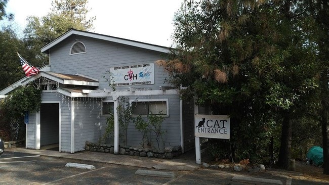


This Property Is For Sale
Property Detail
1333 State Highway 174
101-010-034
1.3 AC PAR A PMOR 18 85
Officebuilding
Placer
B and X Area of moderate flood hazard, usually the area between the limits of the 100-year and 500-year floods.
California
2024
1.30 AC
2025
Outer Placer County
022002
Sacramento
3,586 SF
Sacramento-Roseville-Folsom, CA
NEARBY LISTINGS FOR SALE OR LEASE
-
-
View all Colfax listings for sale on LoopNet.com
DEMOGRAPHICS near 1333 State Highway 174
1 mile
3 mile
5 mile
2025 Total Population
1,121
4,835
9,986
2030 Population
1,081
4,723
9,763
Pop Growth 2025-2030
(3.57%)
(2.32%)
(2.23%)
Average Age
46
46
47
2025 Total Households
476
1,992
4,100
HH Growth 2025-2030
(3.36%)
(2.31%)
(2.27%)
Median Household Inc
$87,042
$87,148
$87,960
Avg Household Size
2.30
2.40
2.40
2025 Avg HH Vehicles
2.00
2.00
3.00
Median Home Value
$448,936
$493,159
$595,101
Median Year Built
1976
1982
1983
Nearby Places
Map Layers
Map Styles
 Street
 Aerial
Layers
 Traffic
 Biking
Places
Listings with unknown addresses are not visible on the map
- Restaurants
- Banks
- Shops
- Fitness
- Groceries
PUBLIC TRANSPORTATION
COMMUTER RAIL
Colfax Amtrak Station (California Zephyr - Amtrak)
Drive
Walk
Distance
Colfax Amtrak Station (California Zephyr - Amtrak)
2 min
1.2 mi
Freight Ports
Port of Stockton
Drive
Walk
Distance
Port of Stockton
113 min
97.1 mi
Nearby Properties
Address
Land Use
TOTAL SIZE
Lot Size
Zoning
Address
Land Use
TOTAL SIZE
Lot Size
Zoning
33,992 SF
2.08 AC
Address
Land Use
TOTAL SIZE
Lot Size
Zoning
9.70 AC
Address
Land Use
TOTAL SIZE
Lot Size
Zoning
45,192 SF
6.74 AC
Address
Land Use
TOTAL SIZE
Lot Size
Zoning
40,344 SF
3.10 AC
Address
Land Use
TOTAL SIZE
Lot Size
Zoning
34,822 SF
8 AC
Address
Land Use
TOTAL SIZE
Lot Size
Zoning
3,680 SF
5.80 AC
Address
Land Use
TOTAL SIZE
Lot Size
Zoning
16,736 SF
6.40 AC
Address
Land Use
TOTAL SIZE
Lot Size
Zoning
3.30 AC
Address
Land Use
TOTAL SIZE
Lot Size
Zoning
4,800 SF
2.24 AC
REC
Address
Land Use
TOTAL SIZE
Lot Size
Zoning
11,060 SF
2.50 AC
Address
Land Use
TOTAL SIZE
Lot Size
Zoning
57,752 SF
3.60 AC
Address
Land Use
TOTAL SIZE
Lot Size
Zoning
22,360 SF
1.80 AC
Address
Land Use
TOTAL SIZE
Lot Size
Zoning
3,235 SF
1.20 AC
Address
Land Use
TOTAL SIZE
Lot Size
Zoning
1,624 SF
0.61 AC
Address
Land Use
TOTAL SIZE
Lot Size
Zoning
4,332 SF
0.98 AC
Address
Land Use
TOTAL SIZE
Lot Size
Zoning
1,107 SF
0.46 AC
Address
Land Use
TOTAL SIZE
Lot Size
Zoning
1,895 SF
Address
Land Use
TOTAL SIZE
Lot Size
Zoning
9,100 SF
1.20 AC
Address
Land Use
TOTAL SIZE
Lot Size
Zoning
15,040 SF
4.30 AC
Address
Land Use
TOTAL SIZE
Lot Size
Zoning
40,700 SF
1.10 AC
Address
Land Use
TOTAL SIZE
Lot Size
Zoning
57.49 AC
AG-10
Address
Land Use
TOTAL SIZE
Lot Size
Zoning
854 SF
263.24 AC
AG20PD
Address
Land Use
TOTAL SIZE
Lot Size
Zoning
600 SF
1.80 AC
Address
Land Use
TOTAL SIZE
Lot Size
Zoning
2,376 SF
0.46 AC
Address
Land Use
TOTAL SIZE
Lot Size
Zoning
1.73 AC
REC
Address
Land Use
TOTAL SIZE
Lot Size
Zoning
14,800 SF
1.40 AC
Address
Land Use
TOTAL SIZE
Lot Size
Zoning
9,504 SF
1 AC
Address
Land Use
TOTAL SIZE
Lot Size
Zoning
3,689 SF
0.30 AC
Address
Land Use
TOTAL SIZE
Lot Size
Zoning
8,556 SF
1.50 AC
Address
Land Use
TOTAL SIZE
Lot Size
Zoning
7,744 SF
0.91 AC
The World's #1 Commercial Real Estate Marketplace
Connect with us
© 2026 CoStar Group
The information above has been obtained from sources believed reliable. While we do not doubt its accuracy we have not verified it and make no guarantee, warranty or representation about it. It is your responsibility to independently confirm its accuracy and completeness. Any projections, opinions, assumptions, or estimates used are for example only and do not represent the current or future performance of the property. The value of this transaction to you depends on tax and other factors which should be evaluated by your tax, financial, and legal advisors. You and your advisors should conduct a careful, independent investigation of the property to determine to your satisfaction the suitability of the property for your needs.