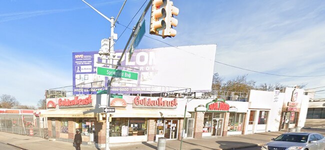
Property Record
13330 Springfield Blvd, Springfield Gardens, NY 11413

Property Detail
13330 Springfield Blvd
12723-0001
QUEENS
Storebuilding
New York
C8-1
1
B and X Area of moderate flood hazard, usually the area between the limits of the 100-year and 500-year floods.
0.10 AC
2025
South Queens
2026
Long Island (New York)
035800
New York-Jersey City-White Plains, NY-NJ
4,245 SF
NEARBY LISTINGS FOR SALE OR LEASE
DEMOGRAPHICS near 13330 Springfield Blvd
1 mile
3 mile
5 mile
2025 Total Population
51,153
410,006
1,015,655
2030 Population
49,478
398,742
994,568
Pop Growth 2025-2030
(3.27%)
(2.75%)
(2.08%)
Average Age
43
42
42
2025 Total Households
16,491
122,766
319,504
HH Growth 2025-2030
(3.68%)
(3.26%)
(2.41%)
Median Household Inc
$99,900
$92,880
$97,275
Avg Household Size
3.00
3.10
3.00
2025 Avg HH Vehicles
1.00
1.00
1.00
Median Home Value
$706,449
$704,730
$714,630
Median Year Built
1950
1952
1951
Nearby Places
Map Layers
Map Styles
 Street
 Aerial
Layers
 Traffic
 Biking
Places
Listings with unknown addresses are not visible on the map
- Restaurants
- Banks
- Shops
- Fitness
- Groceries
PUBLIC TRANSPORTATION
TRANSIT/SUBWAY
Locust Manor Station (Far Rockaway Branch - Long Island Rail Road)
Drive
Walk
Distance
Locust Manor Station (Far Rockaway Branch - Long Island Rail Road)
4 min
17 min
0.9 mi
Laurelton Station (Far Rockaway Branch - Long Island Rail Road)
Drive
Walk
Distance
Laurelton Station (Far Rockaway Branch - Long Island Rail Road)
3 min
19 min
1.0 mi
COMMUTER RAIL
Locust Manor Station (Far Rockaway Branch - Long Island Rail Road)
Drive
Walk
Distance
Locust Manor Station (Far Rockaway Branch - Long Island Rail Road)
4 min
17 min
0.9 mi
Laurelton Station (Far Rockaway Branch - Long Island Rail Road)
Drive
Walk
Distance
Laurelton Station (Far Rockaway Branch - Long Island Rail Road)
3 min
19 min
1.0 mi
AIRPORT
John F Kennedy International
Drive
Walk
Distance
John F Kennedy International
10 min
5.0 mi
LaGuardia
Drive
Walk
Distance
LaGuardia
20 min
11.9 mi
Newark Liberty International
Drive
Walk
Distance
Newark Liberty International
47 min
31.7 mi
Freight Ports
NY - Red Hook Container Terminal
Drive
Walk
Distance
NY - Red Hook Container Terminal
31 min
16.4 mi
SALE & LEASE HISTORY
LISTING DATE
SALE/LEASE

Nov 22, 2022
For Lease
Mar 23, 2022
For Lease
Nearby Properties
Address
Land Use
TOTAL SIZE
Lot Size
Zoning
Address
Land Use
TOTAL SIZE
Lot Size
Zoning
124.60 AC
M1-1
Address
Land Use
TOTAL SIZE
Lot Size
Zoning
294.47 AC
PARK
Address
Land Use
TOTAL SIZE
Lot Size
Zoning
731,247 SF
56.09 AC
R3-2
Address
Land Use
TOTAL SIZE
Lot Size
Zoning
738,000 SF
1.92 AC
C6-3
Address
Land Use
TOTAL SIZE
Lot Size
Zoning
291,589 SF
1.55 AC
C6-3
Address
Land Use
TOTAL SIZE
Lot Size
Zoning
569,583 SF
2.28 AC
C4-5X
Address
Land Use
TOTAL SIZE
Lot Size
Zoning
478,384 SF
1.23 AC
C6-3
Address
Land Use
TOTAL SIZE
Lot Size
Zoning
360,000 SF
8.78 AC
R6
Address
Land Use
TOTAL SIZE
Lot Size
Zoning
208,952 SF
9.03 AC
M1-1
Address
Land Use
TOTAL SIZE
Lot Size
Zoning
295,904 SF
0.63 AC
C6-3
Address
Land Use
TOTAL SIZE
Lot Size
Zoning
285,170 SF
12.63 AC
R3-1
Address
Land Use
TOTAL SIZE
Lot Size
Zoning
240,000 SF
1.91 AC
C6-3
Address
Land Use
TOTAL SIZE
Lot Size
Zoning
50,000 SF
52.45 AC
PARK
Address
Land Use
TOTAL SIZE
Lot Size
Zoning
175,040 SF
10.19 AC
R3X
Address
Land Use
TOTAL SIZE
Lot Size
Zoning
471,648 SF
1.46 AC
C6-3
Address
Land Use
TOTAL SIZE
Lot Size
Zoning
160,551 SF
1.19 AC
C4-2
Address
Land Use
TOTAL SIZE
Lot Size
Zoning
199,864 SF
1.76 AC
C4-5X
Address
Land Use
TOTAL SIZE
Lot Size
Zoning
27.23 AC
PARK
Address
Land Use
TOTAL SIZE
Lot Size
Zoning
129,378 SF
4.86 AC
R2A
Address
Land Use
TOTAL SIZE
Lot Size
Zoning
187,000 SF
3.24 AC
R4-1
Address
Land Use
TOTAL SIZE
Lot Size
Zoning
304,128 SF
3.70 AC
R6
Address
Land Use
TOTAL SIZE
Lot Size
Zoning
41,756 SF
1.02 AC
R5D
Address
Land Use
TOTAL SIZE
Lot Size
Zoning
260,000 SF
3.10 AC
M1-4
Address
Land Use
TOTAL SIZE
Lot Size
Zoning
160,000 SF
4.02 AC
R3-2
Address
Land Use
TOTAL SIZE
Lot Size
Zoning
189,693 SF
2.11 AC
R3-2
Address
Land Use
TOTAL SIZE
Lot Size
Zoning
233,210 SF
1.74 AC
C4-2
Address
Land Use
TOTAL SIZE
Lot Size
Zoning
165,600 SF
2.11 AC
R6
Address
Land Use
TOTAL SIZE
Lot Size
Zoning
93.35 AC
PARK
Address
Land Use
TOTAL SIZE
Lot Size
Zoning
178,870 SF
7.60 AC
M1-1
Address
Land Use
TOTAL SIZE
Lot Size
Zoning
116,353 SF
0.58 AC
R6A
The World's #1 Commercial Real Estate Marketplace
Connect with us
© 2026 CoStar Group
The information above has been obtained from sources believed reliable. While we do not doubt its accuracy we have not verified it and make no guarantee, warranty or representation about it. It is your responsibility to independently confirm its accuracy and completeness. Any projections, opinions, assumptions, or estimates used are for example only and do not represent the current or future performance of the property. The value of this transaction to you depends on tax and other factors which should be evaluated by your tax, financial, and legal advisors. You and your advisors should conduct a careful, independent investigation of the property to determine to your satisfaction the suitability of the property for your needs.