Property Record
13333 103Rd St, Jacksonville, FL 32210


Save to a Folder
{{folder.Name}}
{{folder.ListingIds.length}} Properties
{{folder.ListingIds.length}} Property
Create a New Folder
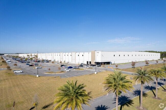
Property Detail
13333 103Rd St
002212-0100
5-93 11-3S-24E 86.05 JACKSONVILLE HEIGHTS PT TRACTS 2,3,14,16, TRACT 15 BLK 4, 12-3S-24E PT TRACTS 4,5,6,8,10 TO 13, TRACT 9 BLK 3, PT UNDEVELOPED R/W RECD O/R 18296-2112 (MINERAL RIGHTS ADJUSTMENT)
Warehouse
Duval
PUD
Florida
AE The base floodplain where base flood elevations are provided. AE Zones are now used on new format FIRMs instead of A1-A30 Zones.
85.89 AC
2025
Riverside
2026
Jacksonville (Florida)
013732
Jacksonville, FL
1,020,863 SF
NEARBY LISTINGS FOR SALE OR LEASE
DEMOGRAPHICS near 13333 103Rd St
1 mile
3 mile
5 mile
2025 Total Population
176
16,777
73,696
2030 Population
194
18,171
79,070
Pop Growth 2025-2030
+ 10.23%
+ 8.31%
+ 7.29%
Average Age
36
38
37
2025 Total Households
59
5,938
26,163
HH Growth 2025-2030
+ 10.17%
+ 8.56%
+ 7.57%
Median Household Inc
$103,125
$87,268
$80,826
Avg Household Size
3.00
2.80
2.80
2025 Avg HH Vehicles
2.00
2.00
2.00
Median Home Value
$345,000
$328,976
$310,806
Median Year Built
2010
2006
2003
Nearby Places
Map Layers
Map Styles
 Street
 Aerial
Layers
 Traffic
 Biking
Places
Listings with unknown addresses are not visible on the map
- Restaurants
- Banks
- Shops
- Fitness
- Groceries
PUBLIC TRANSPORTATION
AIRPORT
Jacksonville International
Drive
Walk
Distance
Jacksonville International
43 min
27.6 mi
Freight Ports
Jacksonville Port
Drive
Walk
Distance
Jacksonville Port
36 min
20.8 mi
Nearby Properties
Address
Land Use
TOTAL SIZE
Lot Size
Zoning
Address
Land Use
TOTAL SIZE
Lot Size
Zoning
1,886,053 SF
5,837.66 AC
PUD
Address
Land Use
TOTAL SIZE
Lot Size
Zoning
1,014,416 SF
80.58 AC
PUD
Address
Land Use
TOTAL SIZE
Lot Size
Zoning
1,043,069 SF
62.83 AC
PUD
Address
Land Use
TOTAL SIZE
Lot Size
Zoning
557,137 SF
40.70 AC
PUD
Address
Land Use
TOTAL SIZE
Lot Size
Zoning
615,718 SF
43.34 AC
PUD
Address
Land Use
TOTAL SIZE
Lot Size
Zoning
239,891 SF
21.95 AC
CRO
Address
Land Use
TOTAL SIZE
Lot Size
Zoning
411,567 SF
35.51 AC
PUD
Address
Land Use
TOTAL SIZE
Lot Size
Zoning
221,429 SF
15.42 AC
PUD
Address
Land Use
TOTAL SIZE
Lot Size
Zoning
307,960 SF
18.52 AC
PUD
Address
Land Use
TOTAL SIZE
Lot Size
Zoning
280,207 SF
37.53 AC
PUD
Address
Land Use
TOTAL SIZE
Lot Size
Zoning
312,832 SF
46.20 AC
PUD
Address
Land Use
TOTAL SIZE
Lot Size
Zoning
318,220 SF
2,016.91 AC
PUD
Address
Land Use
TOTAL SIZE
Lot Size
Zoning
245,626 SF
202.62 AC
PUD
Address
Land Use
TOTAL SIZE
Lot Size
Zoning
58,632 SF
582.79 AC
PUD
Address
Land Use
TOTAL SIZE
Lot Size
Zoning
88,000 SF
11.28 AC
CCG-1
Address
Land Use
TOTAL SIZE
Lot Size
Zoning
138,598 SF
47.95 AC
PBF-2
Address
Land Use
TOTAL SIZE
Lot Size
Zoning
55,621 SF
125.96 AC
PUD
Address
Land Use
TOTAL SIZE
Lot Size
Zoning
392,387 SF
115.92 AC
PUD
Address
Land Use
TOTAL SIZE
Lot Size
Zoning
132,902 SF
204.49 AC
PUD
Address
Land Use
TOTAL SIZE
Lot Size
Zoning
65,052 SF
15.97 AC
PUD
Address
Land Use
TOTAL SIZE
Lot Size
Zoning
292,154 SF
18.68 AC
PUD
Address
Land Use
TOTAL SIZE
Lot Size
Zoning
108,217 SF
178.52 AC
PBF-1
Address
Land Use
TOTAL SIZE
Lot Size
Zoning
6,792 SF
53.56 AC
PUD
Address
Land Use
TOTAL SIZE
Lot Size
Zoning
237,991 SF
11.82 AC
PUD
Address
Land Use
TOTAL SIZE
Lot Size
Zoning
198,713 SF
26.59 AC
PUD
Address
Land Use
TOTAL SIZE
Lot Size
Zoning
10,460 SF
305.51 AC
PUD
Address
Land Use
TOTAL SIZE
Lot Size
Zoning
9,554 SF
2.85 AC
PUD
Address
Land Use
TOTAL SIZE
Lot Size
Zoning
404.50 AC
PUD
Address
Land Use
TOTAL SIZE
Lot Size
Zoning
13.29 AC
PUD
The World's #1 Commercial Real Estate Marketplace
Connect with us
© 2026 CoStar Group
The information above has been obtained from sources believed reliable. While we do not doubt its accuracy we have not verified it and make no guarantee, warranty or representation about it. It is your responsibility to independently confirm its accuracy and completeness. Any projections, opinions, assumptions, or estimates used are for example only and do not represent the current or future performance of the property. The value of this transaction to you depends on tax and other factors which should be evaluated by your tax, financial, and legal advisors. You and your advisors should conduct a careful, independent investigation of the property to determine to your satisfaction the suitability of the property for your needs.