Property Record
13336 N Highway 75, Willis, TX 77378

Save to a Folder
{{folder.Name}}
{{folder.ListingIds.length}} Properties
{{folder.ListingIds.length}} Property
Create a New Folder
Property Detail
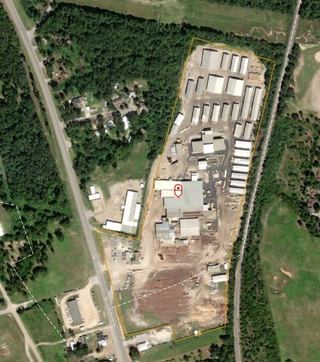
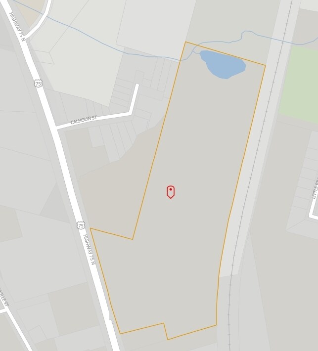
13336 N Highway 75
0313-01-05400
A0313 - LONIS GEO W, TRACT 66-A, 66-B, 67, 72, 73, 75, 78, 79, 80, 81, 103, 103-A (CONFLICT IN TRACT 102), ACRES 33.753
Commercialnec
Montgomery
4
Texas
AE The base floodplain where base flood elevations are provided. AE Zones are now used on new format FIRMs instead of A1-A30 Zones.
33.75 AC
2024
The Woodlands/Conroe
2025
Houston
694105
Houston-Pasadena-The Woodlands, TX
41,158 SF
NEARBY LISTINGS FOR SALE OR LEASE
DEMOGRAPHICS near 13336 N Highway 75
1 mile
3 mile
5 mile
2025 Total Population
4,814
22,526
45,572
2030 Population
5,698
26,749
54,185
Pop Growth 2025-2030
+ 18.36%
+ 18.75%
+ 18.90%
Average Age
36
37
39
2025 Total Households
1,672
7,639
16,281
HH Growth 2025-2030
+ 18.84%
+ 19.31%
+ 19.49%
Median Household Inc
$62,029
$70,467
$77,457
Avg Household Size
2.90
2.90
2.80
2025 Avg HH Vehicles
2.00
2.00
2.00
Median Home Value
$186,134
$244,404
$273,299
Median Year Built
1993
2003
2003
Nearby Places
Map Layers
Map Styles
 Street
 Aerial
Layers
 Traffic
 Biking
Places
Listings with unknown addresses are not visible on the map
- Restaurants
- Banks
- Shops
- Fitness
- Groceries
PUBLIC TRANSPORTATION
AIRPORT
George Bush Intcntl/Houston
Drive
Walk
Distance
George Bush Intcntl/Houston
50 min
40.5 mi
Freight Ports
Port of Houston
Drive
Walk
Distance
Port of Houston
73 min
56.2 mi
Nearby Properties
Address
Land Use
TOTAL SIZE
Lot Size
Zoning
Address
Land Use
TOTAL SIZE
Lot Size
Zoning
Address
Land Use
TOTAL SIZE
Lot Size
Zoning
1,583.40 AC
4
Address
Land Use
TOTAL SIZE
Lot Size
Zoning
448,675 SF
52.68 AC
4
Address
Land Use
TOTAL SIZE
Lot Size
Zoning
117,918 SF
13.63 AC
Address
Land Use
TOTAL SIZE
Lot Size
Zoning
204,759 SF
31.46 AC
Address
Land Use
TOTAL SIZE
Lot Size
Zoning
265,346 SF
74.32 AC
4
Address
Land Use
TOTAL SIZE
Lot Size
Zoning
73,812 SF
9.51 AC
Address
Land Use
TOTAL SIZE
Lot Size
Zoning
87,983 SF
13.90 AC
Address
Land Use
TOTAL SIZE
Lot Size
Zoning
198,970 SF
10.95 AC
Address
Land Use
TOTAL SIZE
Lot Size
Zoning
34,832 SF
31.27 AC
Address
Land Use
TOTAL SIZE
Lot Size
Zoning
31,078 SF
14.11 AC
4
Address
Land Use
TOTAL SIZE
Lot Size
Zoning
27,868 SF
2.97 AC
Address
Land Use
TOTAL SIZE
Lot Size
Zoning
31,019 SF
3.68 AC
4
Address
Land Use
TOTAL SIZE
Lot Size
Zoning
14,486 SF
1.47 AC
Address
Land Use
TOTAL SIZE
Lot Size
Zoning
37,752 SF
25.03 AC
4
Address
Land Use
TOTAL SIZE
Lot Size
Zoning
102,250 SF
9.60 AC
4
Address
Land Use
TOTAL SIZE
Lot Size
Zoning
29,311 SF
9.09 AC
4
Address
Land Use
TOTAL SIZE
Lot Size
Zoning
13,650 SF
1.70 AC
Address
Land Use
TOTAL SIZE
Lot Size
Zoning
15,000 SF
1.84 AC
Address
Land Use
TOTAL SIZE
Lot Size
Zoning
4,420 SF
21.95 AC
4
Address
Land Use
TOTAL SIZE
Lot Size
Zoning
17,048 SF
11.80 AC
4
Address
Land Use
TOTAL SIZE
Lot Size
Zoning
5,380 SF
25.74 AC
Address
Land Use
TOTAL SIZE
Lot Size
Zoning
10.86 AC
Address
Land Use
TOTAL SIZE
Lot Size
Zoning
29,440 SF
5.36 AC
Address
Land Use
TOTAL SIZE
Lot Size
Zoning
16,268 SF
4.37 AC
Address
Land Use
TOTAL SIZE
Lot Size
Zoning
5,920 SF
1.38 AC
Address
Land Use
TOTAL SIZE
Lot Size
Zoning
58,375 SF
20.04 AC
4
The World's #1 Commercial Real Estate Marketplace
Connect with us
© 2026 CoStar Group
The information above has been obtained from sources believed reliable. While we do not doubt its accuracy we have not verified it and make no guarantee, warranty or representation about it. It is your responsibility to independently confirm its accuracy and completeness. Any projections, opinions, assumptions, or estimates used are for example only and do not represent the current or future performance of the property. The value of this transaction to you depends on tax and other factors which should be evaluated by your tax, financial, and legal advisors. You and your advisors should conduct a careful, independent investigation of the property to determine to your satisfaction the suitability of the property for your needs.