Property Record
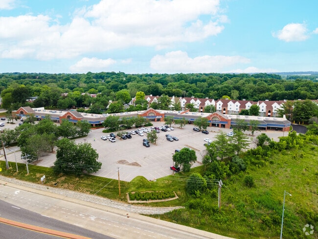
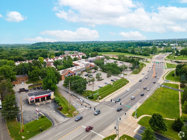
13339 Olive Blvd, Chesterfield, MO 63017

Property Detail
13339 Olive Blvd
16Q-34-0820
SURVEY 0367 SEC 00 TWN 46 RANGE 5 JOHN HEMPSTEAD ESTATE LOT PT 3 BDY ADJ TRACT PT 1 16Q3403 07 11 4 87
Regionalshoppingcenterormallwithanchorstore
ST. LOUIS
105C8
Missouri
B and X Area of moderate flood hazard, usually the area between the limits of the 100-year and 500-year floods.
3
2024
6.37 AC
2025
West County
215105
St. Louis
53,009 SF
St. Louis, MO-IL
NEARBY LISTINGS FOR SALE OR LEASE
-
-
View all Chesterfield listings for lease on LoopNet.com
DEMOGRAPHICS near 13339 Olive Blvd
1 mile
3 mile
5 mile
2025 Total Population
7,942
47,660
122,514
2030 Population
7,801
47,136
121,704
Pop Growth 2025-2030
(1.78%)
(1.10%)
(0.66%)
Average Age
44
43
43
2025 Total Households
3,575
20,320
51,504
HH Growth 2025-2030
(1.82%)
(1.09%)
(0.69%)
Median Household Inc
$95,312
$101,874
$109,540
Avg Household Size
2.20
2.20
2.30
2025 Avg HH Vehicles
2.00
2.00
2.00
Median Home Value
$355,206
$386,314
$383,587
Median Year Built
1972
1975
1976
Nearby Places
Map Layers
Map Styles
 Street
 Aerial
Layers
 Traffic
 Biking
Places
Listings with unknown addresses are not visible on the map
- Restaurants
- Banks
- Shops
- Fitness
- Groceries
PUBLIC TRANSPORTATION
AIRPORT
St Louis Lambert International
Drive
Walk
Distance
St Louis Lambert International
23 min
14.2 mi
Freight Ports
Port Milwaukee
Drive
Walk
Distance
Port Milwaukee
442 min
387.3 mi
SALE & LEASE HISTORY
LISTING DATE
SALE/LEASE

Dec 17, 2020
For Lease
Nearby Properties
Address
Land Use
TOTAL SIZE
Lot Size
Zoning
Address
Land Use
TOTAL SIZE
Lot Size
Zoning
200,372 SF
121.45 AC
105FPNU
Address
Land Use
TOTAL SIZE
Lot Size
Zoning
43,574 SF
55.62 AC
NU
Address
Land Use
TOTAL SIZE
Lot Size
Zoning
3,220 SF
31.26 AC
CB
Address
Land Use
TOTAL SIZE
Lot Size
Zoning
28.46 AC
104NU
Address
Land Use
TOTAL SIZE
Lot Size
Zoning
12,017 SF
122.40 AC
NU
Address
Land Use
TOTAL SIZE
Lot Size
Zoning
26.89 AC
C-8
Address
Land Use
TOTAL SIZE
Lot Size
Zoning
247,860 SF
21.11 AC
105MU
Address
Land Use
TOTAL SIZE
Lot Size
Zoning
272,522 SF
8.70 AC
83POP
Address
Land Use
TOTAL SIZE
Lot Size
Zoning
252,737 SF
24.69 AC
R3
Address
Land Use
TOTAL SIZE
Lot Size
Zoning
337,354 SF
7.40 AC
82CB
Address
Land Use
TOTAL SIZE
Lot Size
Zoning
46,752 SF
3.67 AC
82CB
Address
Land Use
TOTAL SIZE
Lot Size
Zoning
68,279 SF
95.59 AC
NU
Address
Land Use
TOTAL SIZE
Lot Size
Zoning
13.45 AC
PD-M
Address
Land Use
TOTAL SIZE
Lot Size
Zoning
340,320 SF
55.62 AC
NU
Address
Land Use
TOTAL SIZE
Lot Size
Zoning
302,420 SF
13.97 AC
NU
Address
Land Use
TOTAL SIZE
Lot Size
Zoning
297,247 SF
5.40 AC
82CB
Address
Land Use
TOTAL SIZE
Lot Size
Zoning
200,840 SF
12.29 AC
105C8
Address
Land Use
TOTAL SIZE
Lot Size
Zoning
139,980 SF
15.70 AC
83SE
Address
Land Use
TOTAL SIZE
Lot Size
Zoning
10,644 SF
110.98 AC
82HE
Address
Land Use
TOTAL SIZE
Lot Size
Zoning
42,037 SF
193.91 AC
NU
Address
Land Use
TOTAL SIZE
Lot Size
Zoning
36.41 AC
R2
Address
Land Use
TOTAL SIZE
Lot Size
Zoning
389,367 SF
29.15 AC
R6
Address
Land Use
TOTAL SIZE
Lot Size
Zoning
247,086 SF
11.32 AC
104PDM
Address
Land Use
TOTAL SIZE
Lot Size
Zoning
353,407 SF
21.84 AC
104R-4
Address
Land Use
TOTAL SIZE
Lot Size
Zoning
146,175 SF
1.41 AC
83POP
Address
Land Use
TOTAL SIZE
Lot Size
Zoning
212,180 SF
2.03 AC
83POP
Address
Land Use
TOTAL SIZE
Lot Size
Zoning
216,290 SF
10.39 AC
104MXD
Address
Land Use
TOTAL SIZE
Lot Size
Zoning
225,558 SF
14.48 AC
104R-6
Address
Land Use
TOTAL SIZE
Lot Size
Zoning
207,344 SF
6.50 AC
104M-1
Address
Land Use
TOTAL SIZE
Lot Size
Zoning
217,030 SF
16.76 AC
104R-4
The World's #1 Commercial Real Estate Marketplace
Connect with us
© 2026 CoStar Group
The information above has been obtained from sources believed reliable. While we do not doubt its accuracy we have not verified it and make no guarantee, warranty or representation about it. It is your responsibility to independently confirm its accuracy and completeness. Any projections, opinions, assumptions, or estimates used are for example only and do not represent the current or future performance of the property. The value of this transaction to you depends on tax and other factors which should be evaluated by your tax, financial, and legal advisors. You and your advisors should conduct a careful, independent investigation of the property to determine to your satisfaction the suitability of the property for your needs.