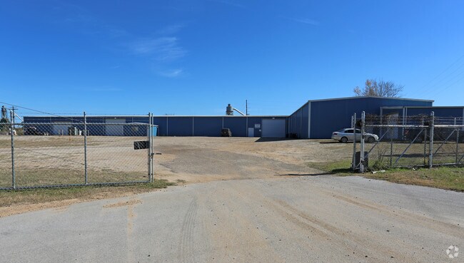
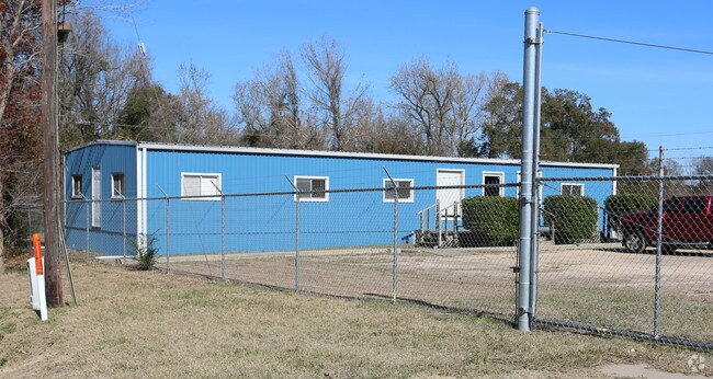
Property Record
13344 N Highway 75, Willis, TX 77378

Property Detail
13344 N Highway 75
0198-00-01400
A0198 A0198 - ELKINS JAMES, TRACT 14, ACRES 5.541
Industrialgeneral
Montgomery
4
Texas
C and X Area of minimal flood hazard, usually depicted on FIRMs as above the 500-year flood level.
5.54 AC
2024
The Woodlands/Conroe
2025
Houston
694105
Houston-Pasadena-The Woodlands, TX
32,966 SF
NEARBY LISTINGS FOR SALE OR LEASE
DEMOGRAPHICS near 13344 N Highway 75
1 mile
3 mile
5 mile
2025 Total Population
4,899
22,737
46,422
2030 Population
5,796
27,012
55,204
Pop Growth 2025-2030
+ 18.31%
+ 18.80%
+ 18.92%
Average Age
36
37
39
2025 Total Households
1,697
7,726
16,612
HH Growth 2025-2030
+ 18.80%
+ 19.38%
+ 19.51%
Median Household Inc
$62,058
$70,632
$78,209
Avg Household Size
2.90
2.90
2.80
2025 Avg HH Vehicles
2.00
2.00
2.00
Median Home Value
$190,986
$246,735
$275,808
Median Year Built
1993
2003
2003
Nearby Places
Map Layers
Map Styles
 Street
 Aerial
Layers
 Traffic
 Biking
Places
Listings with unknown addresses are not visible on the map
- Restaurants
- Banks
- Shops
- Fitness
- Groceries
PUBLIC TRANSPORTATION
AIRPORT
George Bush Intcntl/Houston
Drive
Walk
Distance
George Bush Intcntl/Houston
50 min
40.4 mi
Freight Ports
Port of Houston
Drive
Walk
Distance
Port of Houston
73 min
56.2 mi
Nearby Properties
Address
Land Use
TOTAL SIZE
Lot Size
Zoning
Address
Land Use
TOTAL SIZE
Lot Size
Zoning
Address
Land Use
TOTAL SIZE
Lot Size
Zoning
1,583.40 AC
4
Address
Land Use
TOTAL SIZE
Lot Size
Zoning
448,675 SF
52.68 AC
4
Address
Land Use
TOTAL SIZE
Lot Size
Zoning
251,207 SF
45 AC
Address
Land Use
TOTAL SIZE
Lot Size
Zoning
117,918 SF
13.63 AC
Address
Land Use
TOTAL SIZE
Lot Size
Zoning
204,759 SF
31.46 AC
Address
Land Use
TOTAL SIZE
Lot Size
Zoning
265,346 SF
74.32 AC
4
Address
Land Use
TOTAL SIZE
Lot Size
Zoning
73,812 SF
9.51 AC
Address
Land Use
TOTAL SIZE
Lot Size
Zoning
87,983 SF
13.90 AC
Address
Land Use
TOTAL SIZE
Lot Size
Zoning
198,970 SF
10.95 AC
Address
Land Use
TOTAL SIZE
Lot Size
Zoning
34,832 SF
31.27 AC
Address
Land Use
TOTAL SIZE
Lot Size
Zoning
31,078 SF
14.11 AC
4
Address
Land Use
TOTAL SIZE
Lot Size
Zoning
27,868 SF
2.97 AC
Address
Land Use
TOTAL SIZE
Lot Size
Zoning
31,019 SF
3.68 AC
4
Address
Land Use
TOTAL SIZE
Lot Size
Zoning
14,486 SF
1.47 AC
Address
Land Use
TOTAL SIZE
Lot Size
Zoning
37,752 SF
25.03 AC
4
Address
Land Use
TOTAL SIZE
Lot Size
Zoning
102,250 SF
9.60 AC
4
Address
Land Use
TOTAL SIZE
Lot Size
Zoning
29,311 SF
9.09 AC
4
Address
Land Use
TOTAL SIZE
Lot Size
Zoning
13,650 SF
1.70 AC
Address
Land Use
TOTAL SIZE
Lot Size
Zoning
15,000 SF
1.84 AC
Address
Land Use
TOTAL SIZE
Lot Size
Zoning
4,420 SF
21.95 AC
4
Address
Land Use
TOTAL SIZE
Lot Size
Zoning
17,048 SF
11.80 AC
4
Address
Land Use
TOTAL SIZE
Lot Size
Zoning
41,158 SF
33.75 AC
4
Address
Land Use
TOTAL SIZE
Lot Size
Zoning
5,380 SF
25.74 AC
Address
Land Use
TOTAL SIZE
Lot Size
Zoning
10.86 AC
Address
Land Use
TOTAL SIZE
Lot Size
Zoning
29,440 SF
5.36 AC
Address
Land Use
TOTAL SIZE
Lot Size
Zoning
16,268 SF
4.37 AC
Address
Land Use
TOTAL SIZE
Lot Size
Zoning
5,920 SF
1.38 AC
The World's #1 Commercial Real Estate Marketplace
Connect with us
© 2026 CoStar Group
The information above has been obtained from sources believed reliable. While we do not doubt its accuracy we have not verified it and make no guarantee, warranty or representation about it. It is your responsibility to independently confirm its accuracy and completeness. Any projections, opinions, assumptions, or estimates used are for example only and do not represent the current or future performance of the property. The value of this transaction to you depends on tax and other factors which should be evaluated by your tax, financial, and legal advisors. You and your advisors should conduct a careful, independent investigation of the property to determine to your satisfaction the suitability of the property for your needs.