Property Record
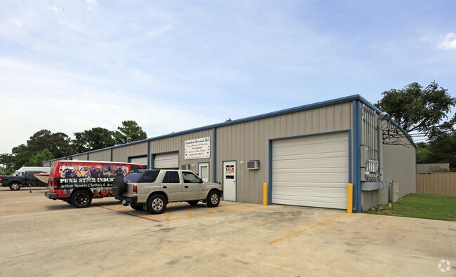
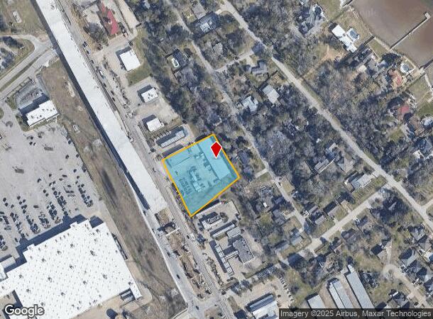
1336 Highway 146, Kemah, TX 77565

NEARBY LISTINGS FOR SALE OR LEASE
Property Detail
1336 Highway 146
Houston-The Woodlands-Sugar Land, TX
Roberts Addn To Kemah
6162-0005-0005-001
ABST 18 M MULDOON SUR PT OF LOT 5,6,10,11 & 12 (5-1) BLK 5 & LOTS 1 THRU 6 BLK 6 E T ROBERTS ADDN UNRECORDED SUB & ADJ ABDN ROW
Commercialnec
Galveston
AE
Texas
48167C0042G
5;lot
2024
1.80 AC
2025
East-Southeast Far
721600
Houston
18,456 SF
DEMOGRAPHICS near 1336 Highway 146
1 Mile
3 Mile
5 Mile
2024 Total Population
2,615
53,139
104,757
2029 Population
2,811
55,284
108,589
Pop Growth 2024-2029
+ 7.50%
+ 4.04%
+ 3.66%
Average Age
40
39
39
2024 Total Households
1,066
20,735
41,140
HH Growth 2024-2029
+ 7.88%
+ 4.22%
+ 3.78%
Median Household Inc
$78,954
$107,825
$96,259
Avg Household Size
2.50
2.50
2.50
2024 Avg HH Vehicles
2.00
2.00
2.00
Median Home Value
$274,215
$296,859
$288,129
Median Year Built
1996
1992
1991
Nearby Places
Map Layers
Map Styles
 Street
 Aerial
- Restaurants
- Banks
- Shops
- Fitness
- Groceries
PUBLIC TRANSPORTATION
AIRPORT
William P Hobby
DRIVE
WALK
Distance
William P Hobby
37 min
21.4 mi
George Bush Intcntl/Houston
DRIVE
WALK
Distance
George Bush Intcntl/Houston
58 min
45.3 mi
Freight Ports
Port of Galveston
DRIVE
WALK
Distance
Port of Galveston
30 min
24.1 mi
Nearby Properties
Address
Land Use
TOTAL SIZE
Lot Size
Zoning
Address
Land Use
TOTAL SIZE
Lot Size
Zoning
500,000 SF
125.06 AC
Address
Land Use
TOTAL SIZE
Lot Size
Zoning
320,892 SF
15 AC
Address
Land Use
TOTAL SIZE
Lot Size
Zoning
372,456 SF
20.15 AC
Address
Land Use
TOTAL SIZE
Lot Size
Zoning
415,941 SF
14.35 AC
Address
Land Use
TOTAL SIZE
Lot Size
Zoning
260,988 SF
11.78 AC
Address
Land Use
TOTAL SIZE
Lot Size
Zoning
370,220 SF
28.57 AC
Address
Land Use
TOTAL SIZE
Lot Size
Zoning
281,944 SF
20.68 AC
Address
Land Use
TOTAL SIZE
Lot Size
Zoning
196,951 SF
10.90 AC
Address
Land Use
TOTAL SIZE
Lot Size
Zoning
253,306 SF
12.33 AC
Address
Land Use
TOTAL SIZE
Lot Size
Zoning
188,850 SF
9.28 AC
Address
Land Use
TOTAL SIZE
Lot Size
Zoning
214,074 SF
12.70 AC
Address
Land Use
TOTAL SIZE
Lot Size
Zoning
207,624 SF
10.66 AC
Address
Land Use
TOTAL SIZE
Lot Size
Zoning
210,641 SF
7.59 AC
Address
Land Use
TOTAL SIZE
Lot Size
Zoning
256,771 SF
3.86 AC
Address
Land Use
TOTAL SIZE
Lot Size
Zoning
197,268 SF
3.43 AC
Address
Land Use
TOTAL SIZE
Lot Size
Zoning
115,444 SF
8.42 AC
Address
Land Use
TOTAL SIZE
Lot Size
Zoning
218,026 SF
13.13 AC
Address
Land Use
TOTAL SIZE
Lot Size
Zoning
180,139 SF
4.72 AC
Address
Land Use
TOTAL SIZE
Lot Size
Zoning
101,211 SF
12.43 AC
Address
Land Use
TOTAL SIZE
Lot Size
Zoning
165,078 SF
8.47 AC
Address
Land Use
TOTAL SIZE
Lot Size
Zoning
254,503 SF
17.70 AC
Address
Land Use
TOTAL SIZE
Lot Size
Zoning
94,901 SF
10 AC
Address
Land Use
TOTAL SIZE
Lot Size
Zoning
90,291 SF
1.81 AC
Address
Land Use
TOTAL SIZE
Lot Size
Zoning
70,954 SF
2.79 AC
Address
Land Use
TOTAL SIZE
Lot Size
Zoning
169,974 SF
8.52 AC
Address
Land Use
TOTAL SIZE
Lot Size
Zoning
206,147 SF
20.51 AC
Address
Land Use
TOTAL SIZE
Lot Size
Zoning
79,018 SF
9.34 AC
Address
Land Use
TOTAL SIZE
Lot Size
Zoning
89,018 SF
8.34 AC
Address
Land Use
TOTAL SIZE
Lot Size
Zoning
114,488 SF
20 AC
Address
Land Use
TOTAL SIZE
Lot Size
Zoning
171,990 SF
11.85 AC
The World's #1 Commercial Real Estate Marketplace
Connect with us
© 2025 CoStar Group
The information above has been obtained from sources believed reliable. While we do not doubt its accuracy we have not verified it and make no guarantee, warranty or representation about it. It is your responsibility to independently confirm its accuracy and completeness. Any projections, opinions, assumptions, or estimates used are for example only and do not represent the current or future performance of the property. The value of this transaction to you depends on tax and other factors which should be evaluated by your tax, financial, and legal advisors. You and your advisors should conduct a careful, independent investigation of the property to determine to your satisfaction the suitability of the property for your needs.