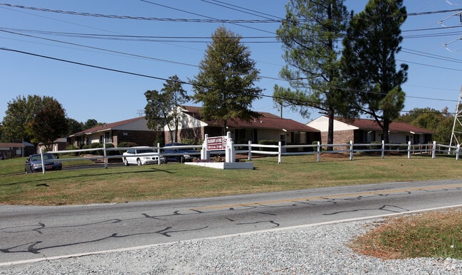
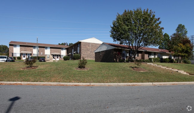
Property Record
1336 N Beaumont Ct, Burlington, NC 27217


NEARBY LISTINGS FOR SALE OR LEASE
-
-
View all Burlington listings for sale on LoopNet.com
Property Detail
1336 N Beaumont Ct
139193
Beaumont Ave Apts Prop
Apartment
BEAUMONT CT 144-581-304
X
Alamance
3710887500K
North Carolina
2025
8.07 AC
2025
North Burlington
020301
Greensboro/Winston-Salem
4,472 SF
Burlington, NC
DEMOGRAPHICS near 1336 N Beaumont Ct
1 Mile
3 Mile
5 Mile
2024 Total Population
9,823
48,823
89,394
2029 Population
10,750
52,789
96,547
Pop Growth 2024-2029
+ 9.44%
+ 8.12%
+ 8.00%
Average Age
39
39
39
2024 Total Households
3,765
19,423
35,622
HH Growth 2024-2029
+ 9.67%
+ 8.29%
+ 8.20%
Median Household Inc
$36,063
$41,703
$49,015
Avg Household Size
2.40
2.40
2.40
2024 Avg HH Vehicles
2.00
2.00
2.00
Median Home Value
$88,322
$124,171
$162,194
Median Year Built
1967
1967
1976
Nearby Places
Map Layers
Map Styles
 Street
 Aerial
- Restaurants
- Banks
- Shops
- Fitness
- Groceries
PUBLIC TRANSPORTATION
COMMUTER RAIL
Burlington Station (Piedmont - North Carolina by Train (NC Train))
DRIVE
WALK
Distance
Burlington Station (Piedmont - North Carolina by Train (NC Train))
5 min
2.4 mi
AIRPORT
Piedmont Triad International
DRIVE
WALK
Distance
Piedmont Triad International
52 min
34.6 mi
Freight Ports
Virginia Port Authority - Richmond
DRIVE
WALK
Distance
Virginia Port Authority - Richmond
208 min
177.9 mi
Nearby Properties
Address
Land Use
TOTAL SIZE
Lot Size
Zoning
Address
Land Use
TOTAL SIZE
Lot Size
Zoning
177,145 SF
47.79 AC
R 15
Address
Land Use
TOTAL SIZE
Lot Size
Zoning
33,280 SF
9.07 AC
I2
Address
Land Use
TOTAL SIZE
Lot Size
Zoning
40,220 SF
12.45 AC
MF A
Address
Land Use
TOTAL SIZE
Lot Size
Zoning
72,164 SF
73.50 AC
Address
Land Use
TOTAL SIZE
Lot Size
Zoning
110,612 SF
1 AC
B 3
Address
Land Use
TOTAL SIZE
Lot Size
Zoning
51,994 SF
42.20 AC
OI
Address
Land Use
TOTAL SIZE
Lot Size
Zoning
9,672 SF
10.77 AC
MF A
Address
Land Use
TOTAL SIZE
Lot Size
Zoning
23,992 SF
25.66 AC
R 9
Address
Land Use
TOTAL SIZE
Lot Size
Zoning
71,962 SF
5.98 AC
O I
Address
Land Use
TOTAL SIZE
Lot Size
Zoning
216,968 SF
25.50 AC
CB
Address
Land Use
TOTAL SIZE
Lot Size
Zoning
40,440 SF
23.57 AC
R 9
Address
Land Use
TOTAL SIZE
Lot Size
Zoning
23,268 SF
6.11 AC
Address
Land Use
TOTAL SIZE
Lot Size
Zoning
59,897 SF
15.40 AC
Address
Land Use
TOTAL SIZE
Lot Size
Zoning
17,073 SF
7.59 AC
R 9
Address
Land Use
TOTAL SIZE
Lot Size
Zoning
32,480 SF
18.44 AC
R 9
Address
Land Use
TOTAL SIZE
Lot Size
Zoning
2,923 SF
10.13 AC
Address
Land Use
TOTAL SIZE
Lot Size
Zoning
158,339 SF
16.34 AC
Address
Land Use
TOTAL SIZE
Lot Size
Zoning
77,046 SF
1.61 AC
I 3
Address
Land Use
TOTAL SIZE
Lot Size
Zoning
5,760 SF
8.34 AC
MF B
Address
Land Use
TOTAL SIZE
Lot Size
Zoning
22,301 SF
19.25 AC
OI
Address
Land Use
TOTAL SIZE
Lot Size
Zoning
60,458 SF
6.82 AC
I 2
Address
Land Use
TOTAL SIZE
Lot Size
Zoning
45,321 SF
31 AC
R 12
Address
Land Use
TOTAL SIZE
Lot Size
Zoning
27,336 SF
10.84 AC
R 6
Address
Land Use
TOTAL SIZE
Lot Size
Zoning
7,800 SF
5.51 AC
Address
Land Use
TOTAL SIZE
Lot Size
Zoning
43,170 SF
6.80 AC
O I
Address
Land Use
TOTAL SIZE
Lot Size
Zoning
33,045 SF
4.03 AC
R 15OFB1
Address
Land Use
TOTAL SIZE
Lot Size
Zoning
41,787 SF
8.07 AC
COI
Address
Land Use
TOTAL SIZE
Lot Size
Zoning
25,200 SF
5.30 AC
Address
Land Use
TOTAL SIZE
Lot Size
Zoning
60,713 SF
3.15 AC
O I
Address
Land Use
TOTAL SIZE
Lot Size
Zoning
41,624 SF
19.77 AC
R 9
The World's #1 Commercial Real Estate Marketplace
Connect with us
© 2025 CoStar Group
The information above has been obtained from sources believed reliable. While we do not doubt its accuracy we have not verified it and make no guarantee, warranty or representation about it. It is your responsibility to independently confirm its accuracy and completeness. Any projections, opinions, assumptions, or estimates used are for example only and do not represent the current or future performance of the property. The value of this transaction to you depends on tax and other factors which should be evaluated by your tax, financial, and legal advisors. You and your advisors should conduct a careful, independent investigation of the property to determine to your satisfaction the suitability of the property for your needs.