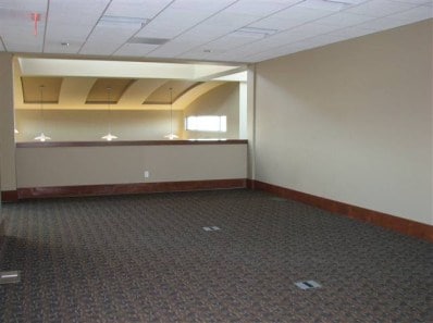
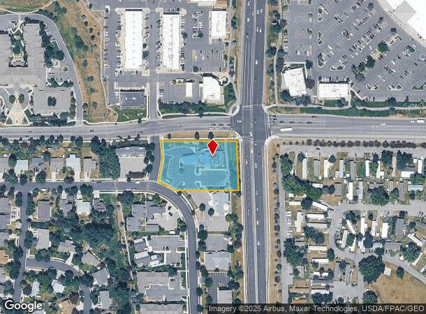
Property Record
1336 Stoneridge Dr, Bozeman, MT 59718
NEARBY LISTINGS FOR SALE OR LEASE
Property Detail
1336 Stoneridge Dr
Bozeman, MT
Stoneridge Sub Pud Ph 2B
06-0798-02-4-07-17-0000
STONERIDGE SUB PUD PH 2B, S02, T02 S, R05 E, LOT 22, ACRES 1.315, PLAT J-352
Financialbuilding
Gallatin
X
Montana
30031C0804D
22
2025
1.32 AC
2025
Bozeman/Yellowstone Country
000506
Other Market Areas
8,095 SF
DEMOGRAPHICS near 1336 Stoneridge Dr
1 Mile
3 Mile
5 Mile
2024 Total Population
11,821
61,906
77,173
2029 Population
13,553
70,821
88,051
Pop Growth 2024-2029
+ 14.65%
+ 14.40%
+ 14.10%
Average Age
36
35
36
2024 Total Households
5,110
25,442
31,377
HH Growth 2024-2029
+ 15.09%
+ 15.32%
+ 14.95%
Median Household Inc
$61,783
$72,466
$81,616
Avg Household Size
2.20
2.20
2.30
2024 Avg HH Vehicles
2.00
2.00
2.00
Median Home Value
$456,586
$554,556
$619,344
Median Year Built
2003
2002
2002
Nearby Places
Map Layers
Map Styles
 Street
 Aerial
- Restaurants
- Banks
- Shops
- Fitness
- Groceries
PUBLIC TRANSPORTATION
AIRPORT
Bozeman Yellowstone International
DRIVE
WALK
Distance
Bozeman Yellowstone International
15 min
8.8 mi
SALE & LEASE HISTORY
LISTING DATE
SALE/LEASE

Apr 04, 2019
For Lease
Nearby Properties
Address
Land Use
TOTAL SIZE
Lot Size
Zoning
Address
Land Use
TOTAL SIZE
Lot Size
Zoning
175,398 SF
34.43 AC
Address
Land Use
TOTAL SIZE
Lot Size
Zoning
15,099 SF
16.05 AC
Address
Land Use
TOTAL SIZE
Lot Size
Zoning
138,308 SF
58.03 AC
Address
Land Use
TOTAL SIZE
Lot Size
Zoning
33,109 SF
9.89 AC
Address
Land Use
TOTAL SIZE
Lot Size
Zoning
67,716 SF
38.83 AC
Address
Land Use
TOTAL SIZE
Lot Size
Zoning
89,441 SF
0.46 AC
6
Address
Land Use
TOTAL SIZE
Lot Size
Zoning
214,283 SF
5.20 AC
Address
Land Use
TOTAL SIZE
Lot Size
Zoning
6,317 SF
9.14 AC
Address
Land Use
TOTAL SIZE
Lot Size
Zoning
23,325 SF
9.82 AC
Address
Land Use
TOTAL SIZE
Lot Size
Zoning
69,093 SF
8.96 AC
BP
Address
Land Use
TOTAL SIZE
Lot Size
Zoning
129,579 SF
9.74 AC
Address
Land Use
TOTAL SIZE
Lot Size
Zoning
10,368 SF
6.75 AC
Address
Land Use
TOTAL SIZE
Lot Size
Zoning
8,100 SF
64.73 AC
Address
Land Use
TOTAL SIZE
Lot Size
Zoning
33,771 SF
7.10 AC
Address
Land Use
TOTAL SIZE
Lot Size
Zoning
85,290 SF
7.82 AC
Address
Land Use
TOTAL SIZE
Lot Size
Zoning
20,118 SF
7.95 AC
Address
Land Use
TOTAL SIZE
Lot Size
Zoning
81,620 SF
10.65 AC
1
Address
Land Use
TOTAL SIZE
Lot Size
Zoning
85,052 SF
1.26 AC
6
Address
Land Use
TOTAL SIZE
Lot Size
Zoning
69,917 SF
0.68 AC
6
Address
Land Use
TOTAL SIZE
Lot Size
Zoning
259,349 SF
B2
Address
Land Use
TOTAL SIZE
Lot Size
Zoning
20,106 SF
8.23 AC
Address
Land Use
TOTAL SIZE
Lot Size
Zoning
96,944 SF
0.44 AC
1
Address
Land Use
TOTAL SIZE
Lot Size
Zoning
149,599 SF
18.41 AC
Address
Land Use
TOTAL SIZE
Lot Size
Zoning
119,732 SF
7.32 AC
Address
Land Use
TOTAL SIZE
Lot Size
Zoning
7,552 SF
8.60 AC
Address
Land Use
TOTAL SIZE
Lot Size
Zoning
90,003 SF
17.01 AC
Address
Land Use
TOTAL SIZE
Lot Size
Zoning
11,639 SF
6.69 AC
Address
Land Use
TOTAL SIZE
Lot Size
Zoning
162,081 SF
4.95 AC
Address
Land Use
TOTAL SIZE
Lot Size
Zoning
19,938 SF
Address
Land Use
TOTAL SIZE
Lot Size
Zoning
90,347 SF
1.74 AC
5
The World's #1 Commercial Real Estate Marketplace
Connect with us
© 2025 CoStar Group
The information above has been obtained from sources believed reliable. While we do not doubt its accuracy we have not verified it and make no guarantee, warranty or representation about it. It is your responsibility to independently confirm its accuracy and completeness. Any projections, opinions, assumptions, or estimates used are for example only and do not represent the current or future performance of the property. The value of this transaction to you depends on tax and other factors which should be evaluated by your tax, financial, and legal advisors. You and your advisors should conduct a careful, independent investigation of the property to determine to your satisfaction the suitability of the property for your needs.