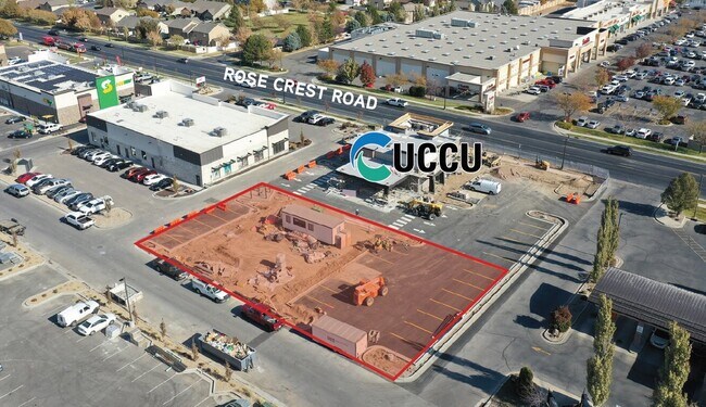
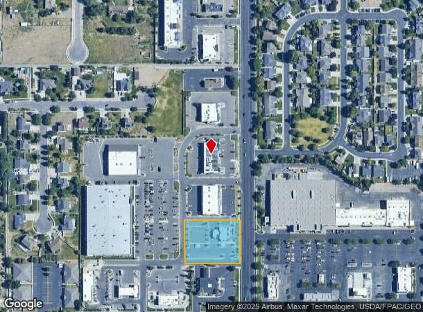
Property Record
13372 S Rosecrest Rd, Herriman, UT 84096
NEARBY LISTINGS FOR SALE OR LEASE
Property Detail
13372 S Rosecrest Rd
Salt Lake City, UT
Herriman Corner Commercial Sub
26-35-476-058-0000
LOT 5, HERRIMAN CORNER COMMERCIAL SUB. 10354-4148
Financialbuilding
Salt Lake
X
Utah
49035C0419G
5
2024
1.02 AC
2025
Southwest Valley
113113
Salt Lake City
2,688 SF
DEMOGRAPHICS near 13372 S Rosecrest Rd
1 Mile
3 Mile
5 Mile
2024 Total Population
17,984
89,575
157,768
2029 Population
18,281
91,571
160,763
Pop Growth 2024-2029
+ 1.65%
+ 2.23%
+ 1.90%
Average Age
31
31
33
2024 Total Households
4,917
24,923
44,661
HH Growth 2024-2029
+ 1.65%
+ 2.27%
+ 1.89%
Median Household Inc
$113,872
$108,217
$110,261
Avg Household Size
3.60
3.60
3.50
2024 Avg HH Vehicles
3.00
2.00
2.00
Median Home Value
$450,660
$488,679
$520,430
Median Year Built
2008
2010
2009
Nearby Places
Map Layers
Map Styles
 Street
 Aerial
- Restaurants
- Banks
- Shops
- Fitness
- Groceries
PUBLIC TRANSPORTATION
COMMUTER RAIL
Draper Station (FrontRunner - Utah Transit Authority (UTA))
DRIVE
WALK
Distance
Draper Station (FrontRunner - Utah Transit Authority (UTA))
14 min
8.0 mi
AIRPORT
Salt Lake City International
DRIVE
WALK
Distance
Salt Lake City International
32 min
22.0 mi
Provo Municipal
DRIVE
WALK
Distance
Provo Municipal
45 min
32.4 mi
Freight Ports
Port of Stockton
DRIVE
WALK
Distance
Port of Stockton
725 min
701.7 mi
SALE & LEASE HISTORY
LISTING DATE
SALE/LEASE

Nov 25, 2020
For Lease
Nearby Properties
Address
Land Use
TOTAL SIZE
Lot Size
Zoning
Address
Land Use
TOTAL SIZE
Lot Size
Zoning
540,554 SF
63.03 AC
C-R
Address
Land Use
TOTAL SIZE
Lot Size
Zoning
285,200 SF
55.78 AC
1210
Address
Land Use
TOTAL SIZE
Lot Size
Zoning
284,727 SF
26.33 AC
4144
Address
Land Use
TOTAL SIZE
Lot Size
Zoning
554,682 SF
30.25 AC
SLR-SP
Address
Land Use
TOTAL SIZE
Lot Size
Zoning
126,150 SF
25.43 AC
RM
Address
Land Use
TOTAL SIZE
Lot Size
Zoning
152,800 SF
85.55 AC
MU2
Address
Land Use
TOTAL SIZE
Lot Size
Zoning
591,044 SF
13.87 AC
C-2
Address
Land Use
TOTAL SIZE
Lot Size
Zoning
702,100 SF
13.83 AC
P-C
Address
Land Use
TOTAL SIZE
Lot Size
Zoning
73,318 SF
1.36 AC
PC
Address
Land Use
TOTAL SIZE
Lot Size
Zoning
269,342 SF
12.68 AC
MU-2
Address
Land Use
TOTAL SIZE
Lot Size
Zoning
323,922 SF
30.86 AC
PCC
Address
Land Use
TOTAL SIZE
Lot Size
Zoning
135,314 SF
21.59 AC
1115
Address
Land Use
TOTAL SIZE
Lot Size
Zoning
137,750 SF
12.64 AC
1210
Address
Land Use
TOTAL SIZE
Lot Size
Zoning
59,711 SF
4.77 AC
C-2
Address
Land Use
TOTAL SIZE
Lot Size
Zoning
333,331 SF
10.13 AC
MU-2
Address
Land Use
TOTAL SIZE
Lot Size
Zoning
348,043 SF
5.35 AC
PC
Address
Land Use
TOTAL SIZE
Lot Size
Zoning
100,474 SF
12.99 AC
R-M-18
Address
Land Use
TOTAL SIZE
Lot Size
Zoning
348,917 SF
6.23 AC
PC
Address
Land Use
TOTAL SIZE
Lot Size
Zoning
456,759 SF
28.63 AC
C-R
Address
Land Use
TOTAL SIZE
Lot Size
Zoning
311,093 SF
39.70 AC
C-2
Address
Land Use
TOTAL SIZE
Lot Size
Zoning
232,874 SF
7.04 AC
RM-18
Address
Land Use
TOTAL SIZE
Lot Size
Zoning
227,345 SF
34.06 AC
M-1
Address
Land Use
TOTAL SIZE
Lot Size
Zoning
228,360 SF
41 AC
PCC
Address
Land Use
TOTAL SIZE
Lot Size
Zoning
272,200 SF
10.66 AC
SPRM18
Address
Land Use
TOTAL SIZE
Lot Size
Zoning
267,421 SF
14.83 AC
Address
Land Use
TOTAL SIZE
Lot Size
Zoning
153,375 SF
23.23 AC
1144
Address
Land Use
TOTAL SIZE
Lot Size
Zoning
234,002 SF
5.95 AC
P-C
Address
Land Use
TOTAL SIZE
Lot Size
Zoning
36.66 AC
PCC
Address
Land Use
TOTAL SIZE
Lot Size
Zoning
734.21 AC
Address
Land Use
TOTAL SIZE
Lot Size
Zoning
54,451 SF
10.74 AC
C-2
The World's #1 Commercial Real Estate Marketplace
Connect with us
© 2025 CoStar Group
The information above has been obtained from sources believed reliable. While we do not doubt its accuracy we have not verified it and make no guarantee, warranty or representation about it. It is your responsibility to independently confirm its accuracy and completeness. Any projections, opinions, assumptions, or estimates used are for example only and do not represent the current or future performance of the property. The value of this transaction to you depends on tax and other factors which should be evaluated by your tax, financial, and legal advisors. You and your advisors should conduct a careful, independent investigation of the property to determine to your satisfaction the suitability of the property for your needs.