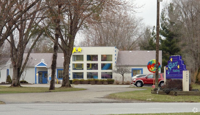
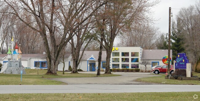
Property Record
13377 State Road 23, Granger, IN 46530

NEARBY LISTINGS FOR SALE OR LEASE
-
-
View all Granger listings for sale on LoopNet.com
Property Detail
13377 State Road 23
South Bend-Mishawaka, IN-MI
Treat Minor Subdivision
71-04-13-201-009.000-011
LOT 2 EX S 12.17 TREAT MINOR SUBDIVISION SEC 13 38 3E 11/12 SPLIT TO STATE FOR STREET 4030WD 6-8-10
Officebuilding
St Joseph
X
Indiana
18141C0094D
2
2023
3.47 AC
2024
Outlying St Joseph County
011404
South Bend/Mishawaka
9,740 SF
DEMOGRAPHICS near 13377 State Road 23
1 Mile
3 Mile
5 Mile
2024 Total Population
3,377
19,733
58,932
2029 Population
3,356
19,456
58,158
Pop Growth 2024-2029
(0.62%)
(1.40%)
(1.31%)
Average Age
38
39
40
2024 Total Households
1,063
6,698
22,601
HH Growth 2024-2029
(0.66%)
(1.46%)
(1.33%)
Median Household Inc
$125,577
$120,530
$89,591
Avg Household Size
3.10
2.90
2.60
2024 Avg HH Vehicles
2.00
2.00
2.00
Median Home Value
$281,264
$274,877
$244,830
Median Year Built
1995
1989
1986
Nearby Places
Map Layers
Map Styles
 Street
 Aerial
- Restaurants
- Banks
- Shops
- Fitness
- Groceries
PUBLIC TRANSPORTATION
AIRPORT
South Bend International
DRIVE
WALK
Distance
South Bend International
32 min
18.0 mi
Freight Ports
Port Milwaukee
DRIVE
WALK
Distance
Port Milwaukee
223 min
185.6 mi
Nearby Properties
Address
Land Use
TOTAL SIZE
Lot Size
Zoning
Address
Land Use
TOTAL SIZE
Lot Size
Zoning
118,884 SF
44 SF
Address
Land Use
TOTAL SIZE
Lot Size
Zoning
138,405 SF
87 SF
Address
Land Use
TOTAL SIZE
Lot Size
Zoning
83,367 SF
5.67 AC
Address
Land Use
TOTAL SIZE
Lot Size
Zoning
70,532 SF
87 SF
Address
Land Use
TOTAL SIZE
Lot Size
Zoning
87,835 SF
29.54 AC
Address
Land Use
TOTAL SIZE
Lot Size
Zoning
120,234 SF
14.79 AC
Address
Land Use
TOTAL SIZE
Lot Size
Zoning
Address
Land Use
TOTAL SIZE
Lot Size
Zoning
113,726 SF
8.38 AC
Address
Land Use
TOTAL SIZE
Lot Size
Zoning
62,184 SF
1.22 AC
Address
Land Use
TOTAL SIZE
Lot Size
Zoning
63,896 SF
0.95 AC
Address
Land Use
TOTAL SIZE
Lot Size
Zoning
43,879 SF
44 SF
Address
Land Use
TOTAL SIZE
Lot Size
Zoning
73,600 SF
44 SF
Address
Land Use
TOTAL SIZE
Lot Size
Zoning
43,172 SF
3.62 AC
Address
Land Use
TOTAL SIZE
Lot Size
Zoning
35,063 SF
87 SF
Address
Land Use
TOTAL SIZE
Lot Size
Zoning
81,550 SF
44 SF
Address
Land Use
TOTAL SIZE
Lot Size
Zoning
61,318 SF
87 SF
Address
Land Use
TOTAL SIZE
Lot Size
Zoning
29,838 SF
44 SF
Address
Land Use
TOTAL SIZE
Lot Size
Zoning
0.02 AC
Address
Land Use
TOTAL SIZE
Lot Size
Zoning
25,366 SF
3.08 AC
Address
Land Use
TOTAL SIZE
Lot Size
Zoning
23,072 SF
3.58 AC
Address
Land Use
TOTAL SIZE
Lot Size
Zoning
30,292 SF
44 SF
Address
Land Use
TOTAL SIZE
Lot Size
Zoning
191,022 SF
9.60 AC
Address
Land Use
TOTAL SIZE
Lot Size
Zoning
12,230 SF
44 SF
Address
Land Use
TOTAL SIZE
Lot Size
Zoning
28,156 SF
4.53 AC
Address
Land Use
TOTAL SIZE
Lot Size
Zoning
196,170 SF
87 SF
Address
Land Use
TOTAL SIZE
Lot Size
Zoning
23,072 SF
3.89 AC
Address
Land Use
TOTAL SIZE
Lot Size
Zoning
161,884 SF
8.30 AC
Address
Land Use
TOTAL SIZE
Lot Size
Zoning
22,750 SF
1.47 AC
Address
Land Use
TOTAL SIZE
Lot Size
Zoning
12,484 SF
174 SF
Address
Land Use
TOTAL SIZE
Lot Size
Zoning
23,199 SF
7.07 AC
The World's #1 Commercial Real Estate Marketplace
Connect with us
© 2025 CoStar Group
The information above has been obtained from sources believed reliable. While we do not doubt its accuracy we have not verified it and make no guarantee, warranty or representation about it. It is your responsibility to independently confirm its accuracy and completeness. Any projections, opinions, assumptions, or estimates used are for example only and do not represent the current or future performance of the property. The value of this transaction to you depends on tax and other factors which should be evaluated by your tax, financial, and legal advisors. You and your advisors should conduct a careful, independent investigation of the property to determine to your satisfaction the suitability of the property for your needs.