Property Record
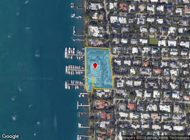
1338 N Lake Way, Palm Beach, FL 33480
NEARBY LISTINGS FOR SALE OR LEASE
Property Detail
1338 N Lake Way
West Palm Beach-Boca Raton-Delray Beach, FL
Cayuga Estate
50-43-43-03-02-000-0022
PL OF WALTON TR N 45 FT OF LT 2~ LT 3~ N 5 FT OF LTS 5 & 8 & LTS 6 & 9 & CAYUGA ESTATES PL 2 PB15P10
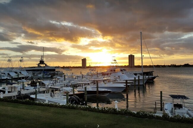
Nightclub
Palm Beach
AE
Florida
12099C0393G
2
2024
3.02 AC
2025
Palm Beach
003507
South Florida
29,427 SF
DEMOGRAPHICS near 1338 N Lake Way
1 Mile
3 Mile
5 Mile
2024 Total Population
4,322
68,256
176,186
2029 Population
4,570
72,738
185,643
Pop Growth 2024-2029
+ 5.74%
+ 6.57%
+ 5.37%
Average Age
45
42
42
2024 Total Households
1,893
27,141
73,587
HH Growth 2024-2029
+ 5.34%
+ 6.72%
+ 5.17%
Median Household Inc
$77,124
$55,413
$60,777
Avg Household Size
2.20
2.30
2.20
2024 Avg HH Vehicles
2.00
1.00
1.00
Median Home Value
$422,414
$391,387
$343,096
Median Year Built
1970
1975
1983
Nearby Places
Map Layers
Map Styles
 Street
 Aerial
- Restaurants
- Banks
- Shops
- Fitness
- Groceries
PUBLIC TRANSPORTATION
COMMUTER RAIL
West Palm Beach (Mainline - Brightline)
DRIVE
WALK
Distance
West Palm Beach (Mainline - Brightline)
13 min
4.9 mi
Mangonia Park (Tri-County Commuter - South Florida Regional Transportation Authority (Tri-Rail))
DRIVE
WALK
Distance
Mangonia Park (Tri-County Commuter - South Florida Regional Transportation Authority (Tri-Rail))
20 min
8.3 mi
AIRPORT
Palm Beach International
DRIVE
WALK
Distance
Palm Beach International
23 min
9.4 mi
Freight Ports
Port of Palm Beach
DRIVE
WALK
Distance
Port of Palm Beach
21 min
8.4 mi
Nearby Properties
Address
Land Use
TOTAL SIZE
Lot Size
Zoning
Address
Land Use
TOTAL SIZE
Lot Size
Zoning
746,972 SF
5.09 AC
CMPD
Address
Land Use
TOTAL SIZE
Lot Size
Zoning
31,761 SF
5.76 AC
R-A
Address
Land Use
TOTAL SIZE
Lot Size
Zoning
138,817 SF
1.90 AC
R-D(2)
Address
Land Use
TOTAL SIZE
Lot Size
Zoning
232,670 SF
6.76 AC
RH
Address
Land Use
TOTAL SIZE
Lot Size
Zoning
739,813 SF
81.18 AC
CSPD
Address
Land Use
TOTAL SIZE
Lot Size
Zoning
411,080 SF
7.59 AC
CPD
Address
Land Use
TOTAL SIZE
Lot Size
Zoning
1.02 AC
R-B
Address
Land Use
TOTAL SIZE
Lot Size
Zoning
740,411 SF
12.88 AC
CSPD
Address
Land Use
TOTAL SIZE
Lot Size
Zoning
4,148 SF
17.33 AC
CF
Address
Land Use
TOTAL SIZE
Lot Size
Zoning
2.23 AC
R-AA
Address
Land Use
TOTAL SIZE
Lot Size
Zoning
252,544 SF
9.95 AC
R1AA
Address
Land Use
TOTAL SIZE
Lot Size
Zoning
119,333 SF
5.81 AC
RH
Address
Land Use
TOTAL SIZE
Lot Size
Zoning
5.81 AC
CMPD
Address
Land Use
TOTAL SIZE
Lot Size
Zoning
12,062 SF
1.54 AC
R-A
Address
Land Use
TOTAL SIZE
Lot Size
Zoning
0.51 AC
R-B
Address
Land Use
TOTAL SIZE
Lot Size
Zoning
7,705 SF
1.24 AC
R-A
Address
Land Use
TOTAL SIZE
Lot Size
Zoning
314,993 SF
38.46 AC
CF
Address
Land Use
TOTAL SIZE
Lot Size
Zoning
96,953 SF
1.61 AC
C
Address
Land Use
TOTAL SIZE
Lot Size
Zoning
161,206 SF
1.87 AC
POR/PD
Address
Land Use
TOTAL SIZE
Lot Size
Zoning
1.95 AC
R-B
Address
Land Use
TOTAL SIZE
Lot Size
Zoning
108,077 SF
9.72 AC
IG
Address
Land Use
TOTAL SIZE
Lot Size
Zoning
185,929 SF
7.56 AC
POR/PD
Address
Land Use
TOTAL SIZE
Lot Size
Zoning
227,512 SF
1.35 AC
LD-4
Address
Land Use
TOTAL SIZE
Lot Size
Zoning
164,082 SF
0.72 AC
CSPD
Address
Land Use
TOTAL SIZE
Lot Size
Zoning
323,628 SF
48.15 AC
IG
Address
Land Use
TOTAL SIZE
Lot Size
Zoning
8,503 SF
0.80 AC
R-B
Address
Land Use
TOTAL SIZE
Lot Size
Zoning
59,943 SF
1.22 AC
C-TS
Address
Land Use
TOTAL SIZE
Lot Size
Zoning
1,540 SF
13.68 AC
CF
Address
Land Use
TOTAL SIZE
Lot Size
Zoning
216,255 SF
25.37 AC
CSPD
Address
Land Use
TOTAL SIZE
Lot Size
Zoning
11,416 SF
0.95 AC
R-B
The World's #1 Commercial Real Estate Marketplace
Connect with us
© 2025 CoStar Group
The information above has been obtained from sources believed reliable. While we do not doubt its accuracy we have not verified it and make no guarantee, warranty or representation about it. It is your responsibility to independently confirm its accuracy and completeness. Any projections, opinions, assumptions, or estimates used are for example only and do not represent the current or future performance of the property. The value of this transaction to you depends on tax and other factors which should be evaluated by your tax, financial, and legal advisors. You and your advisors should conduct a careful, independent investigation of the property to determine to your satisfaction the suitability of the property for your needs.