Property Record
13390 Veterans Memorial Hwy, Douglasville, GA 30134

NEARBY LISTINGS FOR SALE OR LEASE
-
-
-
No Photo
-
-
-
-
-
View all Douglasville listings for sale on LoopNet.com
Property Detail
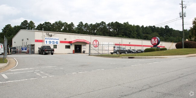
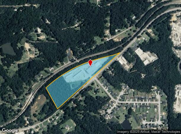
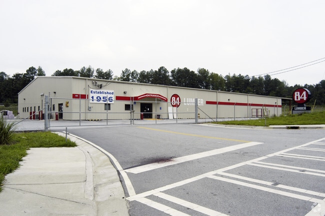
13390 Veterans Memorial Hwy
Atlanta-Sandy Springs-Roswell, GA
Meadows The
5025-01-6-0-011
BLDG/13.8733 ACRES, US HWY 78 (84 LUMBER)
Warehouse
Douglas
X
Georgia
13097C0131E
165
2024
13.87 AC
2024
I-20 W/Douglasville
080408
Atlanta
31,850 SF
DEMOGRAPHICS near 13390 Veterans Memorial Hwy
1 Mile
3 Mile
5 Mile
2024 Total Population
895
21,849
73,522
2029 Population
951
22,995
78,373
Pop Growth 2024-2029
+ 6.26%
+ 5.25%
+ 6.60%
Average Age
40
38
38
2024 Total Households
308
8,117
25,523
HH Growth 2024-2029
+ 6.49%
+ 5.25%
+ 6.58%
Median Household Inc
$43,065
$53,643
$65,887
Avg Household Size
2.90
2.60
2.80
2024 Avg HH Vehicles
2.00
2.00
2.00
Median Home Value
$150,993
$170,689
$194,584
Median Year Built
2000
1990
1993
Nearby Places
Map Layers
Map Styles
 Street
 Aerial
- Restaurants
- Banks
- Shops
- Fitness
- Groceries
PUBLIC TRANSPORTATION
AIRPORT
Hartsfield - Jackson Atlanta International
DRIVE
WALK
Distance
Hartsfield - Jackson Atlanta International
47 min
34.4 mi
Freight Ports
Georgia Ports - Savannah
DRIVE
WALK
Distance
Georgia Ports - Savannah
310 min
273.7 mi
Nearby Properties
Address
Land Use
TOTAL SIZE
Lot Size
Zoning
Address
Land Use
TOTAL SIZE
Lot Size
Zoning
320,483 SF
24.27 AC
DCD
Address
Land Use
TOTAL SIZE
Lot Size
Zoning
299,120 SF
21.37 AC
DCD
Address
Land Use
TOTAL SIZE
Lot Size
Zoning
522,936 SF
39.33 AC
IL
Address
Land Use
TOTAL SIZE
Lot Size
Zoning
500,688 SF
41.29 AC
C-G
Address
Land Use
TOTAL SIZE
Lot Size
Zoning
247,203 SF
18.74 AC
DCD
Address
Land Use
TOTAL SIZE
Lot Size
Zoning
136,748 SF
19 AC
R-6
Address
Land Use
TOTAL SIZE
Lot Size
Zoning
166,816 SF
26.23 AC
R-MF
Address
Land Use
TOTAL SIZE
Lot Size
Zoning
132,754 SF
20.35 AC
R-6
Address
Land Use
TOTAL SIZE
Lot Size
Zoning
338,918 SF
24.51 AC
CG
Address
Land Use
TOTAL SIZE
Lot Size
Zoning
200,233 SF
17.49 AC
R-6
Address
Land Use
TOTAL SIZE
Lot Size
Zoning
224,137 SF
22.83 AC
CG
Address
Land Use
TOTAL SIZE
Lot Size
Zoning
151,822 SF
21.57 AC
CG
Address
Land Use
TOTAL SIZE
Lot Size
Zoning
212,800 SF
32.46 AC
LI
Address
Land Use
TOTAL SIZE
Lot Size
Zoning
87,669 SF
9.44 AC
CG
Address
Land Use
TOTAL SIZE
Lot Size
Zoning
72,268 SF
7.26 AC
Address
Land Use
TOTAL SIZE
Lot Size
Zoning
114,267 SF
11.43 AC
CG
Address
Land Use
TOTAL SIZE
Lot Size
Zoning
78,688 SF
12.17 AC
CG
Address
Land Use
TOTAL SIZE
Lot Size
Zoning
134,175 SF
15.99 AC
001
Address
Land Use
TOTAL SIZE
Lot Size
Zoning
135,300 SF
16.13 AC
CG
Address
Land Use
TOTAL SIZE
Lot Size
Zoning
89,748 SF
2.56 AC
CG
Address
Land Use
TOTAL SIZE
Lot Size
Zoning
129,646 SF
9.80 AC
CG
Address
Land Use
TOTAL SIZE
Lot Size
Zoning
110,828 SF
8.74 AC
CG
Address
Land Use
TOTAL SIZE
Lot Size
Zoning
49,890 SF
2.10 AC
CG
Address
Land Use
TOTAL SIZE
Lot Size
Zoning
101,860 SF
13.58 AC
CG
Address
Land Use
TOTAL SIZE
Lot Size
Zoning
124,543 SF
10.93 AC
CG
Address
Land Use
TOTAL SIZE
Lot Size
Zoning
48,864 SF
5.92 AC
R-6
Address
Land Use
TOTAL SIZE
Lot Size
Zoning
49,880 SF
2.52 AC
CG
Address
Land Use
TOTAL SIZE
Lot Size
Zoning
77,090 SF
8.98 AC
CG
Address
Land Use
TOTAL SIZE
Lot Size
Zoning
46,260 SF
4.02 AC
CG
Address
Land Use
TOTAL SIZE
Lot Size
Zoning
71,186 SF
10.15 AC
C-G
The World's #1 Commercial Real Estate Marketplace
Connect with us
© 2025 CoStar Group
The information above has been obtained from sources believed reliable. While we do not doubt its accuracy we have not verified it and make no guarantee, warranty or representation about it. It is your responsibility to independently confirm its accuracy and completeness. Any projections, opinions, assumptions, or estimates used are for example only and do not represent the current or future performance of the property. The value of this transaction to you depends on tax and other factors which should be evaluated by your tax, financial, and legal advisors. You and your advisors should conduct a careful, independent investigation of the property to determine to your satisfaction the suitability of the property for your needs.