Property Record
13391 E Fm 1097 Rd, Willis, TX 77378


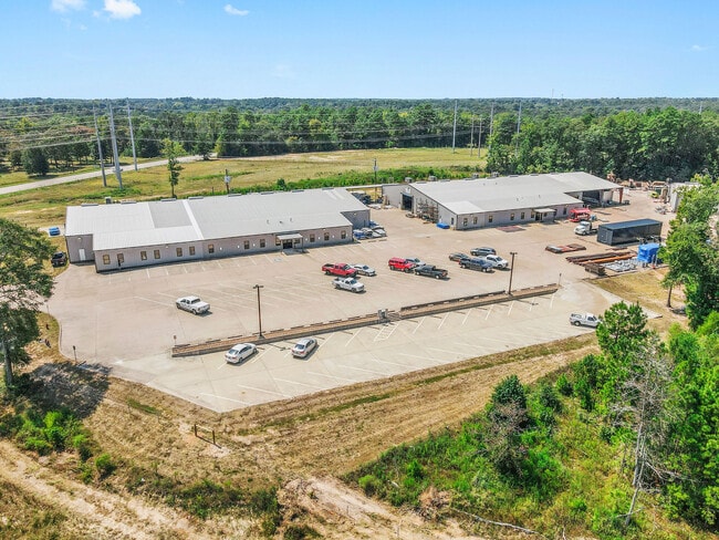
Property Detail
13391 E Fm 1097 Rd
0313-00-00700
A0313 - LONIS GEO W, TRACT 7, ACRES 20.0403
Industrialgeneral
Montgomery
4
Texas
B and X Area of moderate flood hazard, usually the area between the limits of the 100-year and 500-year floods.
20.04 AC
2024
The Woodlands/Conroe
2025
Houston
694106
Houston-Pasadena-The Woodlands, TX
58,375 SF
NEARBY LISTINGS FOR SALE OR LEASE
DEMOGRAPHICS near 13391 E Fm 1097 Rd
1 mile
3 mile
5 mile
2025 Total Population
3,014
19,883
38,180
2030 Population
3,559
23,505
45,312
Pop Growth 2025-2030
+ 18.08%
+ 18.22%
+ 18.68%
Average Age
35
36
38
2025 Total Households
1,001
6,581
13,357
HH Growth 2025-2030
+ 18.68%
+ 18.71%
+ 19.27%
Median Household Inc
$85,301
$69,215
$74,007
Avg Household Size
3.00
3.00
2.80
2025 Avg HH Vehicles
2.00
2.00
2.00
Median Home Value
$228,441
$217,756
$264,442
Median Year Built
2004
2001
2003
Nearby Places
Map Layers
Map Styles
 Street
 Aerial
Transit
 Traffic
 Biking
Places
Listings with unknown addresses are not visible on the map
- Restaurants
- Banks
- Shops
- Fitness
- Groceries
PUBLIC TRANSPORTATION
AIRPORT
George Bush Intcntl/Houston
Drive
Walk
Distance
George Bush Intcntl/Houston
52 min
41.2 mi
SALE & LEASE HISTORY
LISTING DATE
SALE/LEASE

Sep 08, 2021
For Sale
Oct 19, 2021
For Lease
Jan 23, 2024
For Sale
Nearby Properties
Address
Land Use
TOTAL SIZE
Lot Size
Zoning
Address
Land Use
TOTAL SIZE
Lot Size
Zoning
117,918 SF
13.63 AC
Address
Land Use
TOTAL SIZE
Lot Size
Zoning
204,759 SF
31.46 AC
Address
Land Use
TOTAL SIZE
Lot Size
Zoning
265,346 SF
74.32 AC
4
Address
Land Use
TOTAL SIZE
Lot Size
Zoning
73,812 SF
9.51 AC
Address
Land Use
TOTAL SIZE
Lot Size
Zoning
87,983 SF
13.90 AC
Address
Land Use
TOTAL SIZE
Lot Size
Zoning
198,970 SF
10.95 AC
Address
Land Use
TOTAL SIZE
Lot Size
Zoning
34,832 SF
31.27 AC
Address
Land Use
TOTAL SIZE
Lot Size
Zoning
31,078 SF
14.11 AC
4
Address
Land Use
TOTAL SIZE
Lot Size
Zoning
27,868 SF
2.97 AC
Address
Land Use
TOTAL SIZE
Lot Size
Zoning
31,019 SF
3.68 AC
4
Address
Land Use
TOTAL SIZE
Lot Size
Zoning
14,486 SF
1.47 AC
Address
Land Use
TOTAL SIZE
Lot Size
Zoning
37,752 SF
25.03 AC
4
Address
Land Use
TOTAL SIZE
Lot Size
Zoning
29,311 SF
9.09 AC
4
Address
Land Use
TOTAL SIZE
Lot Size
Zoning
13,650 SF
1.70 AC
Address
Land Use
TOTAL SIZE
Lot Size
Zoning
15,000 SF
1.84 AC
Address
Land Use
TOTAL SIZE
Lot Size
Zoning
4,420 SF
21.95 AC
4
Address
Land Use
TOTAL SIZE
Lot Size
Zoning
17,048 SF
11.80 AC
4
Address
Land Use
TOTAL SIZE
Lot Size
Zoning
41,158 SF
33.75 AC
4
Address
Land Use
TOTAL SIZE
Lot Size
Zoning
5,380 SF
25.74 AC
Address
Land Use
TOTAL SIZE
Lot Size
Zoning
10.86 AC
Address
Land Use
TOTAL SIZE
Lot Size
Zoning
29,440 SF
5.36 AC
Address
Land Use
TOTAL SIZE
Lot Size
Zoning
16,268 SF
4.37 AC
Address
Land Use
TOTAL SIZE
Lot Size
Zoning
5,920 SF
1.38 AC
Address
Land Use
TOTAL SIZE
Lot Size
Zoning
9,980 SF
1.03 AC
Address
Land Use
TOTAL SIZE
Lot Size
Zoning
14,998 SF
2.55 AC
4
Address
Land Use
TOTAL SIZE
Lot Size
Zoning
2,325 SF
20 AC
4
Address
Land Use
TOTAL SIZE
Lot Size
Zoning
69,191 SF
26.54 AC
4
The World's #1 Commercial Real Estate Marketplace
Connect with us
© 2026 CoStar Group
The information above has been obtained from sources believed reliable. While we do not doubt its accuracy we have not verified it and make no guarantee, warranty or representation about it. It is your responsibility to independently confirm its accuracy and completeness. Any projections, opinions, assumptions, or estimates used are for example only and do not represent the current or future performance of the property. The value of this transaction to you depends on tax and other factors which should be evaluated by your tax, financial, and legal advisors. You and your advisors should conduct a careful, independent investigation of the property to determine to your satisfaction the suitability of the property for your needs.