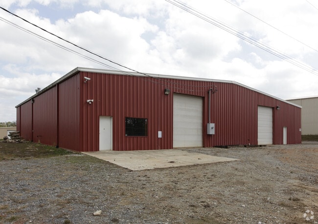
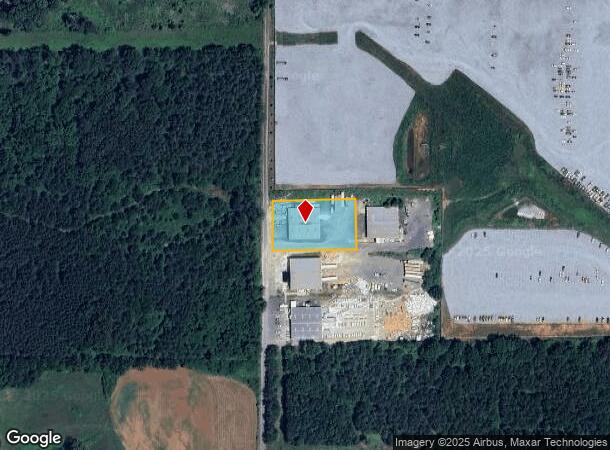
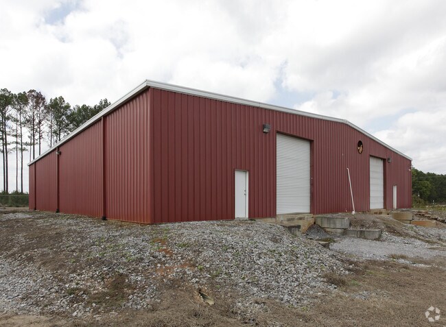
Property Record
134 Beasley Rd Sw, Cartersville, GA 30120
NEARBY LISTINGS FOR SALE OR LEASE
Property Detail
134 Beasley Rd Sw
0052-0972-004
Com - West/Highway 113
Industrialgeneral
LL 972 D 17
X
Bartow
13223C0010D
Georgia
2024
1 AC
2025
Kennesaw/Acworth
961001
Atlanta
10,000 SF
Atlanta-Sandy Springs-Roswell, GA
DEMOGRAPHICS near 134 Beasley Rd Sw
1 mile
3 mile
5 mile
2024 Total Population
36
7,778
17,767
2029 Population
38
8,442
19,389
Pop Growth 2024-2029
+ 5.56%
+ 8.54%
+ 9.13%
Average Age
41
38
39
2024 Total Households
13
2,759
6,213
HH Growth 2024-2029
0.00%
+ 8.30%
+ 8.88%
Median Household Inc
$95,833
$85,392
$87,144
Avg Household Size
2.50
2.80
2.80
2024 Avg HH Vehicles
2.00
2.00
3.00
Median Home Value
$225,000
$212,228
$220,988
Median Year Built
1990
1991
1992
Nearby Places
Map Layers
Map Styles
 Street
 Aerial
Transit
 Traffic
 Biking
Places
Listings with unknown addresses are not visible on the map
- Restaurants
- Banks
- Shops
- Fitness
- Groceries
Nearby Properties
Address
Land Use
TOTAL SIZE
Lot Size
Zoning
Address
Land Use
TOTAL SIZE
Lot Size
Zoning
94,726 SF
34.82 AC
Address
Land Use
TOTAL SIZE
Lot Size
Zoning
132,946 SF
26.63 AC
Address
Land Use
TOTAL SIZE
Lot Size
Zoning
2.74 AC
IN
Address
Land Use
TOTAL SIZE
Lot Size
Zoning
128.74 AC
A1
Address
Land Use
TOTAL SIZE
Lot Size
Zoning
242,214 SF
14.71 AC
IN
Address
Land Use
TOTAL SIZE
Lot Size
Zoning
1,232 SF
56.58 AC
A1
Address
Land Use
TOTAL SIZE
Lot Size
Zoning
85 AC
INDUSTRIAL
Address
Land Use
TOTAL SIZE
Lot Size
Zoning
58,074 SF
20.28 AC
I1
Address
Land Use
TOTAL SIZE
Lot Size
Zoning
91,612 SF
5.44 AC
IN
Address
Land Use
TOTAL SIZE
Lot Size
Zoning
4,068 SF
755.32 AC
A1
Address
Land Use
TOTAL SIZE
Lot Size
Zoning
4,288 SF
690.70 AC
A1
Address
Land Use
TOTAL SIZE
Lot Size
Zoning
744 SF
170.02 AC
A1
Address
Land Use
TOTAL SIZE
Lot Size
Zoning
57.89 AC
IN
Address
Land Use
TOTAL SIZE
Lot Size
Zoning
76,500 SF
Address
Land Use
TOTAL SIZE
Lot Size
Zoning
13,500 SF
55.40 AC
I2
Address
Land Use
TOTAL SIZE
Lot Size
Zoning
21,446 SF
14.87 AC
Address
Land Use
TOTAL SIZE
Lot Size
Zoning
25,480 SF
Address
Land Use
TOTAL SIZE
Lot Size
Zoning
3,909 SF
29.99 AC
A1
Address
Land Use
TOTAL SIZE
Lot Size
Zoning
24,840 SF
5.47 AC
Address
Land Use
TOTAL SIZE
Lot Size
Zoning
51.82 AC
I1
Address
Land Use
TOTAL SIZE
Lot Size
Zoning
8,312 SF
3.51 AC
Address
Land Use
TOTAL SIZE
Lot Size
Zoning
34,440 SF
7.39 AC
C1
Address
Land Use
TOTAL SIZE
Lot Size
Zoning
26,900 SF
8 AC
Address
Land Use
TOTAL SIZE
Lot Size
Zoning
228.37 AC
A1
Address
Land Use
TOTAL SIZE
Lot Size
Zoning
3,840 SF
112.69 AC
A1
Address
Land Use
TOTAL SIZE
Lot Size
Zoning
184 AC
A1
Address
Land Use
TOTAL SIZE
Lot Size
Zoning
242.47 AC
A1
Address
Land Use
TOTAL SIZE
Lot Size
Zoning
54,000 SF
4 AC
IN
Address
Land Use
TOTAL SIZE
Lot Size
Zoning
199 AC
A1
Address
Land Use
TOTAL SIZE
Lot Size
Zoning
7,164 SF
5.75 AC
The World's #1 Commercial Real Estate Marketplace
Connect with us
© 2026 CoStar Group
The information above has been obtained from sources believed reliable. While we do not doubt its accuracy we have not verified it and make no guarantee, warranty or representation about it. It is your responsibility to independently confirm its accuracy and completeness. Any projections, opinions, assumptions, or estimates used are for example only and do not represent the current or future performance of the property. The value of this transaction to you depends on tax and other factors which should be evaluated by your tax, financial, and legal advisors. You and your advisors should conduct a careful, independent investigation of the property to determine to your satisfaction the suitability of the property for your needs.