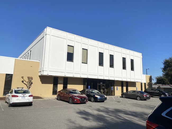
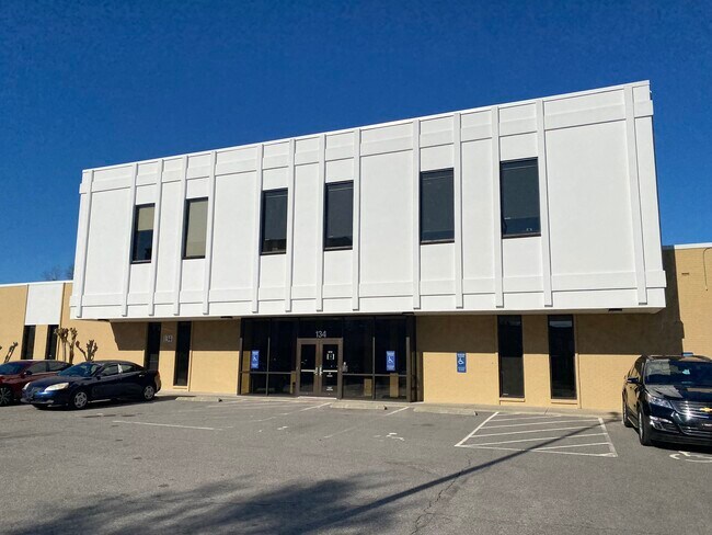
Property Record
147 N Franklin St, Rocky Mount, NC 27804
Current Lease Availabilities
NEARBY LISTINGS FOR SALE OR LEASE
-
-
-
-
-
No Photo
-
-
-
View all Rocky Mount listings for lease on LoopNet.com
Property Detail
147 N Franklin St
3850-19-50-8827
26 11 8,3.28 AC,CENTURA BANK AC,1C,CENTURA BANK
Commercialnec
Nash
X
North Carolina
3720385000K
0.08 AC
2025
Rocky Mount/Wilson
2025
Other Market Areas
010400
Rocky Mount, NC
1,320 SF
DEMOGRAPHICS near 147 N Franklin St
1 Mile
3 Mile
5 Mile
2024 Total Population
8,555
34,967
57,747
2029 Population
8,993
35,754
59,040
Pop Growth 2024-2029
+ 5.12%
+ 2.25%
+ 2.24%
Average Age
42
40
41
2024 Total Households
3,810
14,936
24,623
HH Growth 2024-2029
+ 5.12%
+ 2.34%
+ 2.26%
Median Household Inc
$34,015
$38,584
$45,620
Avg Household Size
2.20
2.30
2.30
2024 Avg HH Vehicles
2.00
2.00
2.00
Median Home Value
$64,237
$101,629
$129,436
Median Year Built
1960
1971
1978
Nearby Places
Map Layers
Map Styles
 Street
 Aerial
- Restaurants
- Banks
- Shops
- Fitness
- Groceries
PUBLIC TRANSPORTATION
COMMUTER RAIL
Rocky Mount (Carolinian - Amtrak, Palmetto - Amtrak, Silver Meteor - Amtrak, Silver Star - Amtrak)
DRIVE
WALK
Distance
Rocky Mount (Carolinian - Amtrak, Palmetto - Amtrak, Silver Meteor - Amtrak, Silver Star - Amtrak)
1 min
11 min
0.6 mi
Freight Ports
Virginia Port Authority - Portsmouth
DRIVE
WALK
Distance
Virginia Port Authority - Portsmouth
162 min
136.6 mi
Nearby Properties
Address
Land Use
TOTAL SIZE
Lot Size
Zoning
Address
Land Use
TOTAL SIZE
Lot Size
Zoning
7,020 SF
33.70 AC
R6
Address
Land Use
TOTAL SIZE
Lot Size
Zoning
2,500 SF
14.61 AC
R6
Address
Land Use
TOTAL SIZE
Lot Size
Zoning
129,595 SF
11.35 AC
B2CU
Address
Land Use
TOTAL SIZE
Lot Size
Zoning
130,639 SF
60.52 AC
A1M
Address
Land Use
TOTAL SIZE
Lot Size
Zoning
104,995 SF
16.01 AC
Address
Land Use
TOTAL SIZE
Lot Size
Zoning
10,632 SF
16.61 AC
R6
Address
Land Use
TOTAL SIZE
Lot Size
Zoning
78,052 SF
122.10 AC
I2
Address
Land Use
TOTAL SIZE
Lot Size
Zoning
27,990 SF
5.75 AC
R10
Address
Land Use
TOTAL SIZE
Lot Size
Zoning
79,027 SF
33.37 AC
R10
Address
Land Use
TOTAL SIZE
Lot Size
Zoning
165,000 SF
4.66 AC
Address
Land Use
TOTAL SIZE
Lot Size
Zoning
29,504 SF
18.61 AC
Address
Land Use
TOTAL SIZE
Lot Size
Zoning
6,976 SF
15.97 AC
R6
Address
Land Use
TOTAL SIZE
Lot Size
Zoning
8,216 SF
4.21 AC
B4
Address
Land Use
TOTAL SIZE
Lot Size
Zoning
65,826 SF
16.77 AC
Address
Land Use
TOTAL SIZE
Lot Size
Zoning
204,903 SF
23.07 AC
Address
Land Use
TOTAL SIZE
Lot Size
Zoning
8,822 SF
9.70 AC
R6
Address
Land Use
TOTAL SIZE
Lot Size
Zoning
32,051 SF
18.50 AC
R6
Address
Land Use
TOTAL SIZE
Lot Size
Zoning
15,650 SF
32.25 AC
R10
Address
Land Use
TOTAL SIZE
Lot Size
Zoning
51,543 SF
9.61 AC
I
Address
Land Use
TOTAL SIZE
Lot Size
Zoning
47,968 SF
4.68 AC
I
Address
Land Use
TOTAL SIZE
Lot Size
Zoning
118,800 SF
5.51 AC
I
Address
Land Use
TOTAL SIZE
Lot Size
Zoning
13,075 SF
14.90 AC
Address
Land Use
TOTAL SIZE
Lot Size
Zoning
6,253 SF
16.22 AC
A1
Address
Land Use
TOTAL SIZE
Lot Size
Zoning
135,400 SF
21.45 AC
B2
Address
Land Use
TOTAL SIZE
Lot Size
Zoning
129,264 SF
31.28 AC
B3
Address
Land Use
TOTAL SIZE
Lot Size
Zoning
42,449 SF
2.49 AC
I2
Address
Land Use
TOTAL SIZE
Lot Size
Zoning
61,850 SF
10 AC
I2
Address
Land Use
TOTAL SIZE
Lot Size
Zoning
253,009 SF
52.80 AC
B3
Address
Land Use
TOTAL SIZE
Lot Size
Zoning
79,481 SF
14.25 AC
R6
Address
Land Use
TOTAL SIZE
Lot Size
Zoning
26,401 SF
7.50 AC
R10
The World's #1 Commercial Real Estate Marketplace
Connect with us
© 2025 CoStar Group
The information above has been obtained from sources believed reliable. While we do not doubt its accuracy we have not verified it and make no guarantee, warranty or representation about it. It is your responsibility to independently confirm its accuracy and completeness. Any projections, opinions, assumptions, or estimates used are for example only and do not represent the current or future performance of the property. The value of this transaction to you depends on tax and other factors which should be evaluated by your tax, financial, and legal advisors. You and your advisors should conduct a careful, independent investigation of the property to determine to your satisfaction the suitability of the property for your needs.