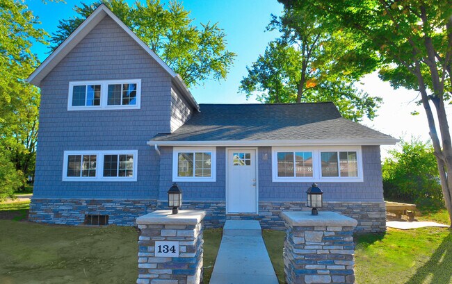
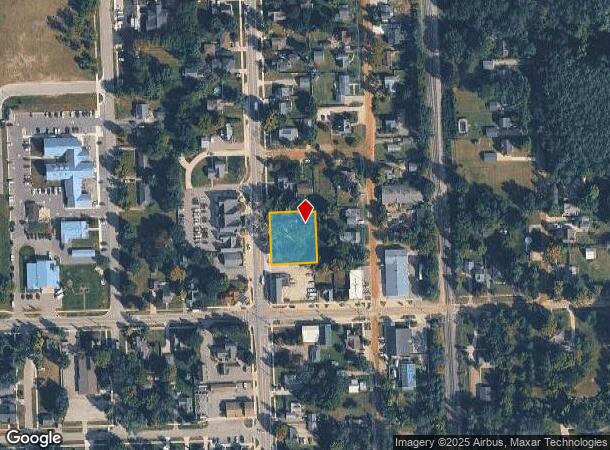
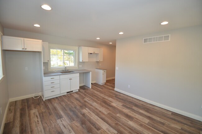
Property Record
134 N Milford Rd, Highland, MI 48357
NEARBY LISTINGS FOR SALE OR LEASE
-
-
View all Highland listings for sale on LoopNet.com
Property Detail
134 N Milford Rd
Detroit-Warren-Dearborn, MI
Ruggles St Johns Plat
11-22-379-015
Oakland
Sfr
Michigan
X
0.45 AC
26125C0313F
Central I-96 Corridor
1,785 SF
Detroit
DEMOGRAPHICS near 134 N Milford Rd
1 Mile
3 Mile
5 Mile
2024 Total Population
2,544
17,946
47,980
2029 Population
2,600
17,980
47,867
Pop Growth 2024-2029
+ 2.20%
+ 0.19%
(0.24%)
Average Age
42
43
43
2024 Total Households
919
6,883
18,538
HH Growth 2024-2029
+ 1.85%
+ 0.10%
(0.29%)
Median Household Inc
$105,935
$95,828
$96,268
Avg Household Size
2.80
2.60
2.50
2024 Avg HH Vehicles
2.00
2.00
2.00
Median Home Value
$426,540
$331,178
$338,021
Median Year Built
1996
1984
1985
Nearby Places
Map Layers
Map Styles
 Street
 Aerial
- Restaurants
- Banks
- Shops
- Fitness
- Groceries
PUBLIC TRANSPORTATION
AIRPORT
Bishop International
DRIVE
WALK
Distance
Bishop International
48 min
32.7 mi
Freight Ports
Port of Toledo
DRIVE
WALK
Distance
Port of Toledo
107 min
85.2 mi
SALE & LEASE HISTORY
LISTING DATE
SALE/LEASE

Oct 27, 2020
For Lease
Oct 27, 2020
For Sale
May 17, 2021
For Sale
Nearby Properties
Address
Land Use
TOTAL SIZE
Lot Size
Zoning
Address
Land Use
TOTAL SIZE
Lot Size
Zoning
6,498 SF
77.52 AC
MM
Address
Land Use
TOTAL SIZE
Lot Size
Zoning
83,159 SF
34.44 AC
Address
Land Use
TOTAL SIZE
Lot Size
Zoning
46,500 SF
5.86 AC
BI
Address
Land Use
TOTAL SIZE
Lot Size
Zoning
603.37 AC
FC
Address
Land Use
TOTAL SIZE
Lot Size
Zoning
34,854 SF
5.28 AC
AI
Address
Land Use
TOTAL SIZE
Lot Size
Zoning
45,644 SF
7.74 AC
BI
Address
Land Use
TOTAL SIZE
Lot Size
Zoning
38,846 SF
6.78 AC
BI
Address
Land Use
TOTAL SIZE
Lot Size
Zoning
34,075 SF
14.06 AC
BI
Address
Land Use
TOTAL SIZE
Lot Size
Zoning
51,167 SF
11.08 AC
BI
Address
Land Use
TOTAL SIZE
Lot Size
Zoning
55,183 SF
Address
Land Use
TOTAL SIZE
Lot Size
Zoning
24,016 SF
7.90 AC
AV
Address
Land Use
TOTAL SIZE
Lot Size
Zoning
47,204 SF
10.77 AC
II
Address
Land Use
TOTAL SIZE
Lot Size
Zoning
24,370 SF
4.86 AC
BI
Address
Land Use
TOTAL SIZE
Lot Size
Zoning
27,756 SF
228.31 AC
Address
Land Use
TOTAL SIZE
Lot Size
Zoning
53,236 SF
9.68 AC
BI
Address
Land Use
TOTAL SIZE
Lot Size
Zoning
47,996 SF
8.99 AC
BI
Address
Land Use
TOTAL SIZE
Lot Size
Zoning
36,928 SF
5.16 AC
II
Address
Land Use
TOTAL SIZE
Lot Size
Zoning
58,721 SF
7.59 AC
BI
Address
Land Use
TOTAL SIZE
Lot Size
Zoning
34,464 SF
7.45 AC
AI
Address
Land Use
TOTAL SIZE
Lot Size
Zoning
68,340 SF
5.48 AC
II
Address
Land Use
TOTAL SIZE
Lot Size
Zoning
21,000 SF
3.12 AC
BI
Address
Land Use
TOTAL SIZE
Lot Size
Zoning
58,677 SF
16.70 AC
II
Address
Land Use
TOTAL SIZE
Lot Size
Zoning
59,200 SF
6 AC
II
Address
Land Use
TOTAL SIZE
Lot Size
Zoning
37,646 SF
7.53 AC
SI
Address
Land Use
TOTAL SIZE
Lot Size
Zoning
25,432 SF
4.53 AC
AI
Address
Land Use
TOTAL SIZE
Lot Size
Zoning
22,605 SF
3.79 AC
BI
Address
Land Use
TOTAL SIZE
Lot Size
Zoning
12,463 SF
4.73 AC
Address
Land Use
TOTAL SIZE
Lot Size
Zoning
38,449 SF
2.60 AC
IV
Address
Land Use
TOTAL SIZE
Lot Size
Zoning
50.93 AC
MM
Address
Land Use
TOTAL SIZE
Lot Size
Zoning
10,404 SF
2.08 AC
BV
The World's #1 Commercial Real Estate Marketplace
Connect with us
© 2025 CoStar Group
The information above has been obtained from sources believed reliable. While we do not doubt its accuracy we have not verified it and make no guarantee, warranty or representation about it. It is your responsibility to independently confirm its accuracy and completeness. Any projections, opinions, assumptions, or estimates used are for example only and do not represent the current or future performance of the property. The value of this transaction to you depends on tax and other factors which should be evaluated by your tax, financial, and legal advisors. You and your advisors should conduct a careful, independent investigation of the property to determine to your satisfaction the suitability of the property for your needs.