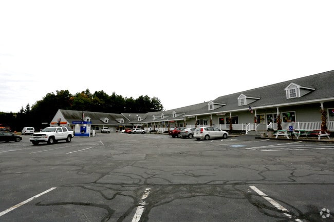
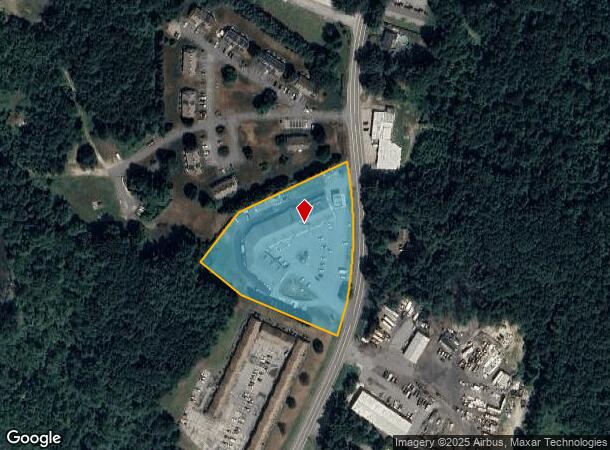
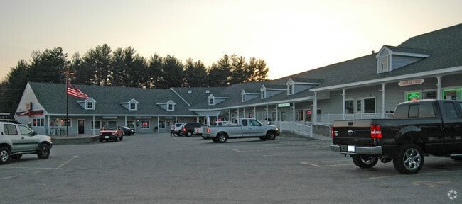
Property Record
134 Newton Rd, Plaistow, NH 03865
NEARBY LISTINGS FOR SALE OR LEASE
-
-
No Photo
-
-
-
-
-
View all Plaistow listings for lease on LoopNet.com
Property Detail
134 Newton Rd
PLSW-000070-000020
Rockingham
Regionalshoppingcenterormallwithanchorstore
New Hampshire
X
000
25009C0083G
12 AC
2024
Rockingham
2024
Boston
101101
Boston-Cambridge-Newton, MA-NH
21,223 SF
DEMOGRAPHICS near 134 Newton Rd
1 Mile
3 Mile
5 Mile
2024 Total Population
1,375
21,195
80,231
2029 Population
1,416
21,476
80,102
Pop Growth 2024-2029
+ 2.98%
+ 1.33%
(0.16%)
Average Age
43
44
41
2024 Total Households
517
8,157
31,285
HH Growth 2024-2029
+ 2.90%
+ 1.19%
(0.24%)
Median Household Inc
$118,037
$108,337
$86,319
Avg Household Size
2.60
2.50
2.50
2024 Avg HH Vehicles
2.00
2.00
2.00
Median Home Value
$444,392
$428,540
$411,449
Median Year Built
1983
1979
1967
Nearby Places
Map Layers
Map Styles
 Street
 Aerial
- Restaurants
- Banks
- Shops
- Fitness
- Groceries
PUBLIC TRANSPORTATION
COMMUTER RAIL
Haverhill (Haverhill Line - Massachusetts Bay Transportation Authority Commuter Rail (Purple Line))
DRIVE
WALK
Distance
Haverhill (Haverhill Line - Massachusetts Bay Transportation Authority Commuter Rail (Purple Line))
10 min
5.0 mi
Bradford (Haverhill Line - Massachusetts Bay Transportation Authority Commuter Rail (Purple Line))
DRIVE
WALK
Distance
Bradford (Haverhill Line - Massachusetts Bay Transportation Authority Commuter Rail (Purple Line))
11 min
5.4 mi
AIRPORT
Portsmouth International at Pease
DRIVE
WALK
Distance
Portsmouth International at Pease
44 min
29.0 mi
Manchester Boston Regional
DRIVE
WALK
Distance
Manchester Boston Regional
56 min
35.9 mi
Freight Ports
Port of Boston
DRIVE
WALK
Distance
Port of Boston
61 min
42.8 mi
SALE & LEASE HISTORY
LISTING DATE
SALE/LEASE

Oct 15, 2018
For Lease
Nearby Properties
Address
Land Use
TOTAL SIZE
Lot Size
Zoning
Address
Land Use
TOTAL SIZE
Lot Size
Zoning
481,367 SF
166.72 AC
Address
Land Use
TOTAL SIZE
Lot Size
Zoning
109.09 AC
Address
Land Use
TOTAL SIZE
Lot Size
Zoning
169,340 SF
14.95 AC
C-1
Address
Land Use
TOTAL SIZE
Lot Size
Zoning
125,627 SF
46.02 AC
C-1
Address
Land Use
TOTAL SIZE
Lot Size
Zoning
35,633 SF
19.15 AC
C-1
Address
Land Use
TOTAL SIZE
Lot Size
Zoning
2,400 SF
4 AC
MDR
Address
Land Use
TOTAL SIZE
Lot Size
Zoning
102,352 SF
19.50 AC
Address
Land Use
TOTAL SIZE
Lot Size
Zoning
63,461 SF
7.61 AC
Address
Land Use
TOTAL SIZE
Lot Size
Zoning
74,723 SF
5.15 AC
Address
Land Use
TOTAL SIZE
Lot Size
Zoning
8.54 AC
RH
Address
Land Use
TOTAL SIZE
Lot Size
Zoning
63,258 SF
8.01 AC
RH
Address
Land Use
TOTAL SIZE
Lot Size
Zoning
16.87 AC
Address
Land Use
TOTAL SIZE
Lot Size
Zoning
115,088 SF
27.42 AC
Address
Land Use
TOTAL SIZE
Lot Size
Zoning
2.09 AC
LDR
Address
Land Use
TOTAL SIZE
Lot Size
Zoning
51.41 AC
Address
Land Use
TOTAL SIZE
Lot Size
Zoning
127,248 SF
18.69 AC
C-1
Address
Land Use
TOTAL SIZE
Lot Size
Zoning
39,670 SF
26.55 AC
RES-A
Address
Land Use
TOTAL SIZE
Lot Size
Zoning
74,516 SF
13.40 AC
VR
Address
Land Use
TOTAL SIZE
Lot Size
Zoning
55,960 SF
12.42 AC
I
Address
Land Use
TOTAL SIZE
Lot Size
Zoning
184,193 SF
24.80 AC
I
Address
Land Use
TOTAL SIZE
Lot Size
Zoning
32,074 SF
6.69 AC
C-1
Address
Land Use
TOTAL SIZE
Lot Size
Zoning
6.80 AC
RH
Address
Land Use
TOTAL SIZE
Lot Size
Zoning
70,433 SF
30.77 AC
VC
Address
Land Use
TOTAL SIZE
Lot Size
Zoning
79,184 SF
9.96 AC
C-3
Address
Land Use
TOTAL SIZE
Lot Size
Zoning
52,802 SF
12.50 AC
SR
Address
Land Use
TOTAL SIZE
Lot Size
Zoning
130,422 SF
16.95 AC
LIGHT
Address
Land Use
TOTAL SIZE
Lot Size
Zoning
16,020 SF
6.68 AC
VC
Address
Land Use
TOTAL SIZE
Lot Size
Zoning
28,747 SF
43.58 AC
Address
Land Use
TOTAL SIZE
Lot Size
Zoning
27,648 SF
2.16 AC
VR
Address
Land Use
TOTAL SIZE
Lot Size
Zoning
2.10 AC
The World's #1 Commercial Real Estate Marketplace
Connect with us
© 2026 CoStar Group
The information above has been obtained from sources believed reliable. While we do not doubt its accuracy we have not verified it and make no guarantee, warranty or representation about it. It is your responsibility to independently confirm its accuracy and completeness. Any projections, opinions, assumptions, or estimates used are for example only and do not represent the current or future performance of the property. The value of this transaction to you depends on tax and other factors which should be evaluated by your tax, financial, and legal advisors. You and your advisors should conduct a careful, independent investigation of the property to determine to your satisfaction the suitability of the property for your needs.