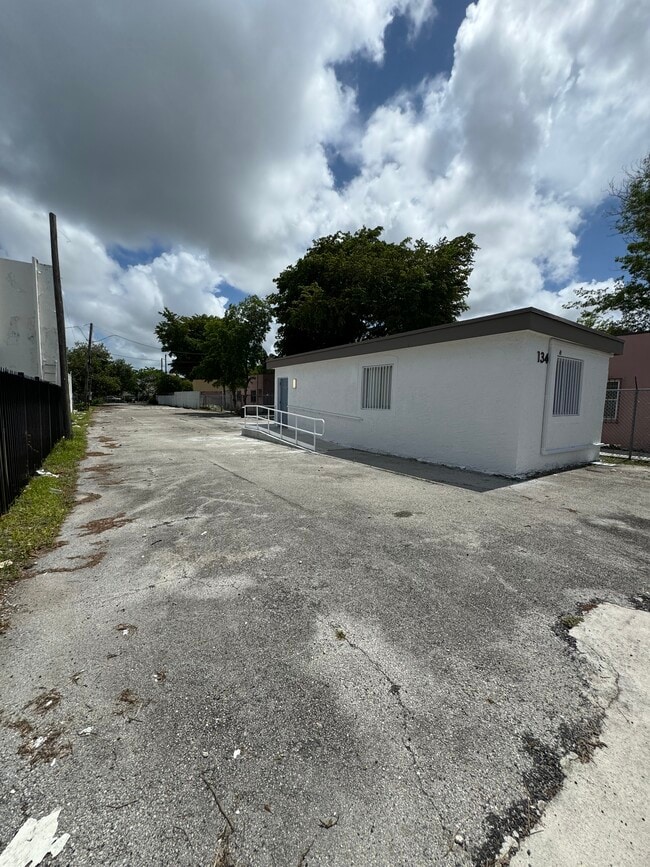
Property Record
134 Nw 79Th St, Miami, FL 33150


Current Lease Availabilities
NEARBY LISTINGS FOR SALE OR LEASE
Property Detail
134 Nw 79Th St
Miami-Miami Beach-Kendall, FL
Phoenix Pk Sub
01-3112-048-0100
PHOENIX PK SUB PB 6-80 E40FT LOT 12 BLK 1 LOT SIZE IRREGULAR OR 20366-2978 0402 3
Officebuilding
Miami/Dade
X
Florida
12086C0302L
12
2024
0.29 AC
2025
Miami
001401
South Florida
442 SF
DEMOGRAPHICS near 134 Nw 79Th St
1 Mile
3 Mile
5 Mile
2024 Total Population
24,591
186,751
514,095
2029 Population
23,939
184,286
508,258
Pop Growth 2024-2029
(2.65%)
(1.32%)
(1.14%)
Average Age
39
39
40
2024 Total Households
9,417
68,448
194,644
HH Growth 2024-2029
(2.96%)
(1.39%)
(1.03%)
Median Household Inc
$34,420
$44,959
$47,168
Avg Household Size
2.50
2.60
2.50
2024 Avg HH Vehicles
1.00
1.00
1.00
Median Home Value
$425,679
$373,968
$364,177
Median Year Built
1964
1964
1969
Nearby Places
Map Layers
Map Styles
 Street
 Aerial
- Restaurants
- Banks
- Shops
- Fitness
- Groceries
PUBLIC TRANSPORTATION
COMMUTER RAIL
Tri-Rail and Metrorail Transfer Station (Tri-County Commuter - South Florida Regional Transportation Authority (Tri-Rail))
DRIVE
WALK
Distance
Tri-Rail and Metrorail Transfer Station (Tri-County Commuter - South Florida Regional Transportation Authority (Tri-Rail))
11 min
3.8 mi
Hialeah Market (Tri-County Commuter - South Florida Regional Transportation Authority (Tri-Rail))
DRIVE
WALK
Distance
Hialeah Market (Tri-County Commuter - South Florida Regional Transportation Authority (Tri-Rail))
12 min
6.8 mi
AIRPORT
Miami International
DRIVE
WALK
Distance
Miami International
28 min
14.5 mi
Fort Lauderdale/Hollywood International
DRIVE
WALK
Distance
Fort Lauderdale/Hollywood International
27 min
18.4 mi
Freight Ports
Port of Miami
DRIVE
WALK
Distance
Port of Miami
1 min
4.9 mi
Nearby Properties
Address
Land Use
TOTAL SIZE
Lot Size
Zoning
Address
Land Use
TOTAL SIZE
Lot Size
Zoning
16.13 AC
6100
Address
Land Use
TOTAL SIZE
Lot Size
Zoning
1,938,271 SF
6.62 AC
6402
Address
Land Use
TOTAL SIZE
Lot Size
Zoning
868,860 SF
2.14 AC
6402
Address
Land Use
TOTAL SIZE
Lot Size
Zoning
615,785 SF
3.81 AC
4604
Address
Land Use
TOTAL SIZE
Lot Size
Zoning
701,056 SF
1.58 AC
6402
Address
Land Use
TOTAL SIZE
Lot Size
Zoning
600,250 SF
2.03 AC
6402
Address
Land Use
TOTAL SIZE
Lot Size
Zoning
519,775 SF
2.27 AC
6100
Address
Land Use
TOTAL SIZE
Lot Size
Zoning
768,663 SF
2.85 AC
4600
Address
Land Use
TOTAL SIZE
Lot Size
Zoning
595,100 SF
0.92 AC
4604
Address
Land Use
TOTAL SIZE
Lot Size
Zoning
264,272 SF
2.18 AC
6110
Address
Land Use
TOTAL SIZE
Lot Size
Zoning
657,769 SF
6.12 AC
6200
Address
Land Use
TOTAL SIZE
Lot Size
Zoning
567,884 SF
4.51 AC
4000
Address
Land Use
TOTAL SIZE
Lot Size
Zoning
520,016 SF
1.89 AC
5000
Address
Land Use
TOTAL SIZE
Lot Size
Zoning
456,344 SF
1.29 AC
6110
Address
Land Use
TOTAL SIZE
Lot Size
Zoning
763,761 SF
8 AC
6402
Address
Land Use
TOTAL SIZE
Lot Size
Zoning
179,418 SF
1.95 AC
6101
Address
Land Use
TOTAL SIZE
Lot Size
Zoning
393,219 SF
1.11 AC
6100
Address
Land Use
TOTAL SIZE
Lot Size
Zoning
446,109 SF
3.54 AC
4600
Address
Land Use
TOTAL SIZE
Lot Size
Zoning
656,930 SF
37.70 AC
8200
Address
Land Use
TOTAL SIZE
Lot Size
Zoning
363,010 SF
19.13 AC
8000
Address
Land Use
TOTAL SIZE
Lot Size
Zoning
1,168 SF
4.60 AC
6402
Address
Land Use
TOTAL SIZE
Lot Size
Zoning
121,320 SF
2.22 AC
6101
Address
Land Use
TOTAL SIZE
Lot Size
Zoning
99,433 SF
2.27 AC
6402
Address
Land Use
TOTAL SIZE
Lot Size
Zoning
680,945 SF
35.56 AC
6400
Address
Land Use
TOTAL SIZE
Lot Size
Zoning
253,926 SF
2.79 AC
3900
Address
Land Use
TOTAL SIZE
Lot Size
Zoning
569,763 SF
31.75 AC
3900
Address
Land Use
TOTAL SIZE
Lot Size
Zoning
260,820 SF
1.63 AC
6100
Address
Land Use
TOTAL SIZE
Lot Size
Zoning
293,276 SF
39.44 AC
8200
Address
Land Use
TOTAL SIZE
Lot Size
Zoning
28,694 SF
1.07 AC
6110
Address
Land Use
TOTAL SIZE
Lot Size
Zoning
237,425 SF
1.11 AC
6100
The World's #1 Commercial Real Estate Marketplace
Connect with us
© 2025 CoStar Group
The information above has been obtained from sources believed reliable. While we do not doubt its accuracy we have not verified it and make no guarantee, warranty or representation about it. It is your responsibility to independently confirm its accuracy and completeness. Any projections, opinions, assumptions, or estimates used are for example only and do not represent the current or future performance of the property. The value of this transaction to you depends on tax and other factors which should be evaluated by your tax, financial, and legal advisors. You and your advisors should conduct a careful, independent investigation of the property to determine to your satisfaction the suitability of the property for your needs.