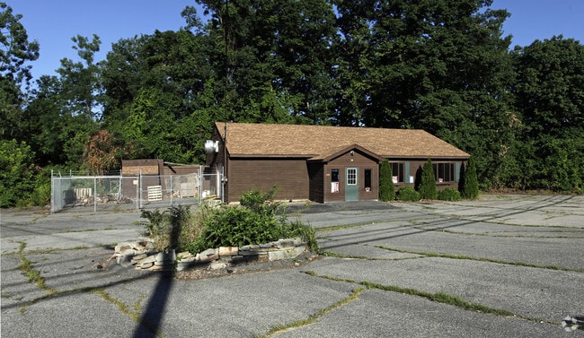
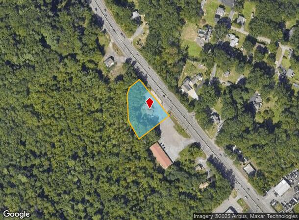
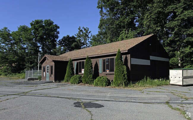
Property Record
134 Worcester Providence Tpke, Millbury, MA 01527
NEARBY LISTINGS FOR SALE OR LEASE
Property Detail
134 Worcester Providence Tpke
Departmentstore
Worcester
X
Massachusetts
25027C0817E
1.10 AC
2025
Outlying Worcester
2025
Boston
737100
Worcester, MA-CT
2,256 SF
MILB-000071-000000-000020
DEMOGRAPHICS near 134 Worcester Providence Tpke
1 Mile
3 Mile
5 Mile
2024 Total Population
3,788
19,187
79,662
2029 Population
3,756
19,128
79,391
Pop Growth 2024-2029
(0.84%)
(0.31%)
(0.34%)
Average Age
44
43
41
2024 Total Households
1,648
7,842
31,050
HH Growth 2024-2029
(0.97%)
(0.34%)
(0.33%)
Median Household Inc
$93,999
$104,027
$91,626
Avg Household Size
2.20
2.40
2.40
2024 Avg HH Vehicles
2.00
2.00
2.00
Median Home Value
$358,160
$387,143
$373,107
Median Year Built
1957
1969
1969
Nearby Places
Map Layers
Map Styles
 Street
 Aerial
- Restaurants
- Banks
- Shops
- Fitness
- Groceries
PUBLIC TRANSPORTATION
AIRPORT
Worcester Regional
DRIVE
WALK
Distance
Worcester Regional
23 min
14.9 mi
Freight Ports
Port of Boston
DRIVE
WALK
Distance
Port of Boston
64 min
49.5 mi
Nearby Properties
Address
Land Use
TOTAL SIZE
Lot Size
Zoning
Address
Land Use
TOTAL SIZE
Lot Size
Zoning
423,649 SF
33.23 AC
B2
Address
Land Use
TOTAL SIZE
Lot Size
Zoning
200,557 SF
13.09 AC
R1
Address
Land Use
TOTAL SIZE
Lot Size
Zoning
Address
Land Use
TOTAL SIZE
Lot Size
Zoning
42.92 AC
R1
Address
Land Use
TOTAL SIZE
Lot Size
Zoning
55.79 AC
R4
Address
Land Use
TOTAL SIZE
Lot Size
Zoning
151.20 AC
Address
Land Use
TOTAL SIZE
Lot Size
Zoning
18.10 AC
I1
Address
Land Use
TOTAL SIZE
Lot Size
Zoning
Address
Land Use
TOTAL SIZE
Lot Size
Zoning
13,417 SF
28.90 AC
MG-.5
Address
Land Use
TOTAL SIZE
Lot Size
Zoning
10.19 AC
B2
Address
Land Use
TOTAL SIZE
Lot Size
Zoning
1,628 SF
7.06 AC
Address
Land Use
TOTAL SIZE
Lot Size
Zoning
71,622 SF
33.28 AC
Address
Land Use
TOTAL SIZE
Lot Size
Zoning
96,000 SF
Address
Land Use
TOTAL SIZE
Lot Size
Zoning
103,460 SF
8.41 AC
I2
Address
Land Use
TOTAL SIZE
Lot Size
Zoning
336,046 SF
36.36 AC
Address
Land Use
TOTAL SIZE
Lot Size
Zoning
109,500 SF
7.40 AC
V
Address
Land Use
TOTAL SIZE
Lot Size
Zoning
64,848 SF
1.76 AC
I1
Address
Land Use
TOTAL SIZE
Lot Size
Zoning
14.85 AC
MG-2
Address
Land Use
TOTAL SIZE
Lot Size
Zoning
163,281 SF
27.96 AC
I2
Address
Land Use
TOTAL SIZE
Lot Size
Zoning
9.60 AC
I
Address
Land Use
TOTAL SIZE
Lot Size
Zoning
107.27 AC
Address
Land Use
TOTAL SIZE
Lot Size
Zoning
9,200 SF
19.24 AC
I1
Address
Land Use
TOTAL SIZE
Lot Size
Zoning
59,950 SF
6.66 AC
OLI
Address
Land Use
TOTAL SIZE
Lot Size
Zoning
6.05 AC
SI
Address
Land Use
TOTAL SIZE
Lot Size
Zoning
7.47 AC
Address
Land Use
TOTAL SIZE
Lot Size
Zoning
66,366 SF
4.87 AC
I2
Address
Land Use
TOTAL SIZE
Lot Size
Zoning
18,450 SF
3.77 AC
B2
Address
Land Use
TOTAL SIZE
Lot Size
Zoning
138.50 AC
I1
Address
Land Use
TOTAL SIZE
Lot Size
Zoning
136.75 AC
R1
Address
Land Use
TOTAL SIZE
Lot Size
Zoning
24,315 SF
1.04 AC
B1
The World's #1 Commercial Real Estate Marketplace
Connect with us
© 2025 CoStar Group
The information above has been obtained from sources believed reliable. While we do not doubt its accuracy we have not verified it and make no guarantee, warranty or representation about it. It is your responsibility to independently confirm its accuracy and completeness. Any projections, opinions, assumptions, or estimates used are for example only and do not represent the current or future performance of the property. The value of this transaction to you depends on tax and other factors which should be evaluated by your tax, financial, and legal advisors. You and your advisors should conduct a careful, independent investigation of the property to determine to your satisfaction the suitability of the property for your needs.