Property Record
1340 S Bend Ave, South Bend, IN 46617
NEARBY LISTINGS FOR SALE OR LEASE
-
-
View all South Bend listings for sale on LoopNet.com
Property Detail
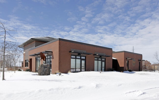
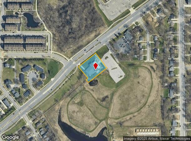
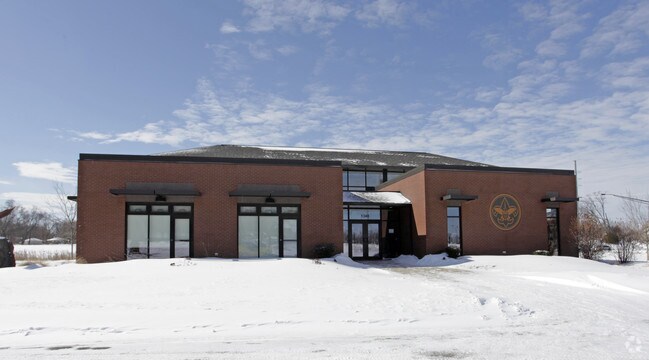
1340 S Bend Ave
South Bend-Mishawaka, IN-MI
Lasalle Council Bsa Minor Sub
71-09-06-176-001.000-026
LOT 1 LASALLE COUNCIL BSA MINOR SUB NP #5961 8-07-06
Privateschool
St Joseph
X
Indiana
18141C0203D
1
0
0.81 AC
2024
Greater South Bend
001000
South Bend/Mishawaka
8,741 SF
DEMOGRAPHICS near 1340 S Bend Ave
1 Mile
3 Mile
5 Mile
2024 Total Population
18,195
103,472
188,566
2029 Population
18,524
104,370
188,844
Pop Growth 2024-2029
+ 1.81%
+ 0.87%
+ 0.15%
Average Age
31
36
38
2024 Total Households
5,475
40,123
74,885
HH Growth 2024-2029
+ 3.16%
+ 0.90%
+ 0.13%
Median Household Inc
$60,216
$48,730
$52,190
Avg Household Size
2.10
2.20
2.30
2024 Avg HH Vehicles
1.00
1.00
2.00
Median Home Value
$196,249
$128,167
$138,757
Median Year Built
1977
1958
1962
Nearby Places
Map Layers
Map Styles
 Street
 Aerial
- Restaurants
- Banks
- Shops
- Fitness
- Groceries
PUBLIC TRANSPORTATION
COMMUTER RAIL
South Bend Amtrak Station (Capitol Limited - Amtrak, Lake Shore Limited - Amtrak)
DRIVE
WALK
Distance
South Bend Amtrak Station (Capitol Limited - Amtrak, Lake Shore Limited - Amtrak)
9 min
3.8 mi
South Bend Airport Station (South Shore Line - Northern Indiana Commuter Transportation District (South Shore Line))
DRIVE
WALK
Distance
South Bend Airport Station (South Shore Line - Northern Indiana Commuter Transportation District (South Shore Line))
12 min
5.4 mi
AIRPORT
South Bend International
DRIVE
WALK
Distance
South Bend International
21 min
7.6 mi
Freight Ports
Port Milwaukee
DRIVE
WALK
Distance
Port Milwaukee
219 min
180.6 mi
Nearby Properties
Address
Land Use
TOTAL SIZE
Lot Size
Zoning
Address
Land Use
TOTAL SIZE
Lot Size
Zoning
3,879,729 SF
436.76 AC
Address
Land Use
TOTAL SIZE
Lot Size
Zoning
685,709 SF
44 SF
Address
Land Use
TOTAL SIZE
Lot Size
Zoning
808,463 SF
30.51 AC
Address
Land Use
TOTAL SIZE
Lot Size
Zoning
24,392 SF
48.07 AC
Address
Land Use
TOTAL SIZE
Lot Size
Zoning
966,201 SF
0.01 AC
Address
Land Use
TOTAL SIZE
Lot Size
Zoning
294,502 SF
87 SF
Address
Land Use
TOTAL SIZE
Lot Size
Zoning
291,729 SF
0.79 AC
Address
Land Use
TOTAL SIZE
Lot Size
Zoning
369,116 SF
19.80 AC
Address
Land Use
TOTAL SIZE
Lot Size
Zoning
168,997 SF
9.62 AC
Address
Land Use
TOTAL SIZE
Lot Size
Zoning
397,501 SF
3.50 AC
Address
Land Use
TOTAL SIZE
Lot Size
Zoning
599,502 SF
39.10 AC
Address
Land Use
TOTAL SIZE
Lot Size
Zoning
394,459 SF
44 SF
Address
Land Use
TOTAL SIZE
Lot Size
Zoning
538,338 SF
0.01 AC
Address
Land Use
TOTAL SIZE
Lot Size
Zoning
160,546 SF
Address
Land Use
TOTAL SIZE
Lot Size
Zoning
319,715 SF
2.57 AC
Address
Land Use
TOTAL SIZE
Lot Size
Zoning
151,377 SF
0.01 AC
Address
Land Use
TOTAL SIZE
Lot Size
Zoning
206,651 SF
1.68 AC
Address
Land Use
TOTAL SIZE
Lot Size
Zoning
770,407 SF
0.01 AC
Address
Land Use
TOTAL SIZE
Lot Size
Zoning
393,123 SF
2.91 AC
Address
Land Use
TOTAL SIZE
Lot Size
Zoning
207,846 SF
2.33 AC
Address
Land Use
TOTAL SIZE
Lot Size
Zoning
799,664 SF
0.01 AC
Address
Land Use
TOTAL SIZE
Lot Size
Zoning
331,913 SF
30 AC
Address
Land Use
TOTAL SIZE
Lot Size
Zoning
158,616 SF
0.85 AC
Address
Land Use
TOTAL SIZE
Lot Size
Zoning
148,524 SF
1.66 AC
Address
Land Use
TOTAL SIZE
Lot Size
Zoning
25,756 SF
337.40 AC
Address
Land Use
TOTAL SIZE
Lot Size
Zoning
327,618 SF
39.65 AC
Address
Land Use
TOTAL SIZE
Lot Size
Zoning
174,997 SF
0.70 AC
Address
Land Use
TOTAL SIZE
Lot Size
Zoning
128,298 SF
0.84 AC
Address
Land Use
TOTAL SIZE
Lot Size
Zoning
187,073 SF
11.52 AC
Address
Land Use
TOTAL SIZE
Lot Size
Zoning
73,254 SF
96.72 AC
The World's #1 Commercial Real Estate Marketplace
Connect with us
© 2025 CoStar Group
The information above has been obtained from sources believed reliable. While we do not doubt its accuracy we have not verified it and make no guarantee, warranty or representation about it. It is your responsibility to independently confirm its accuracy and completeness. Any projections, opinions, assumptions, or estimates used are for example only and do not represent the current or future performance of the property. The value of this transaction to you depends on tax and other factors which should be evaluated by your tax, financial, and legal advisors. You and your advisors should conduct a careful, independent investigation of the property to determine to your satisfaction the suitability of the property for your needs.