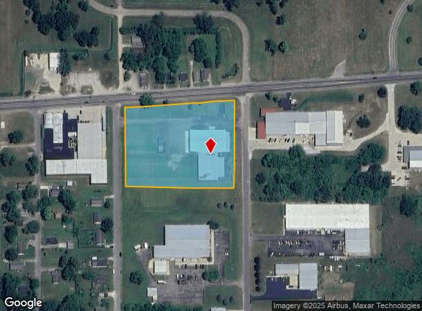
Property Record
1340 Territorial Rd, Benton Harbor, MI 49022

NEARBY LISTINGS FOR SALE OR LEASE
Property Detail
1340 Territorial Rd
Niles-Benton Harbor, MI
Belmont Acres
11-03-0800-0001-09-1
BEG AT NW COR LOT 1 BELMONT ACRES TH N86DEG03'20E 481.63' TH S00DEG14'E 412.05' TH S89DEG46'W 480.62' TO W LN SD BELMONT ACRES TH N00DEG14'00"W 380.88' TO POB
Commercialnec
Berrien
X
Michigan
26021C0106C
1
2024
4.37 AC
2025
Michigan Southwest Area
002200
Other Market Areas
23,278 SF
DEMOGRAPHICS near 1340 Territorial Rd
1 Mile
3 Mile
5 Mile
2024 Total Population
4,004
24,769
39,819
2029 Population
4,018
24,649
39,322
Pop Growth 2024-2029
+ 0.35%
(0.48%)
(1.25%)
Average Age
33
37
40
2024 Total Households
1,422
9,775
16,702
HH Growth 2024-2029
+ 0.14%
(0.83%)
(1.60%)
Median Household Inc
$24,465
$30,363
$42,451
Avg Household Size
2.60
2.40
2.30
2024 Avg HH Vehicles
1.00
1.00
2.00
Median Home Value
$83,137
$125,239
$176,296
Median Year Built
1964
1961
1960
Nearby Places
Map Layers
Map Styles
 Street
 Aerial
- Restaurants
- Banks
- Shops
- Fitness
- Groceries
PUBLIC TRANSPORTATION
COMMUTER RAIL
St. Joseph-Benton Harbor Amtrak Station (Pere Marquette - Amtrak)
DRIVE
WALK
Distance
St. Joseph-Benton Harbor Amtrak Station (Pere Marquette - Amtrak)
7 min
3.7 mi
AIRPORT
South Bend International
DRIVE
WALK
Distance
South Bend International
49 min
35.8 mi
Freight Ports
Port Milwaukee
DRIVE
WALK
Distance
Port Milwaukee
223 min
186.1 mi
SALE & LEASE HISTORY
LISTING DATE
SALE/LEASE

Oct 03, 2019
For Sale
May 27, 2021
For Sale
Feb 25, 2019
For Sale
Nearby Properties
Address
Land Use
TOTAL SIZE
Lot Size
Zoning
Address
Land Use
TOTAL SIZE
Lot Size
Zoning
313,588 SF
11.48 AC
DISTRICT A
Address
Land Use
TOTAL SIZE
Lot Size
Zoning
365,903 SF
95.25 AC
Address
Land Use
TOTAL SIZE
Lot Size
Zoning
216,232 SF
Address
Land Use
TOTAL SIZE
Lot Size
Zoning
89,062 SF
1.60 AC
W
Address
Land Use
TOTAL SIZE
Lot Size
Zoning
99,468 SF
10.07 AC
DISTRICT G
Address
Land Use
TOTAL SIZE
Lot Size
Zoning
218,334 SF
25.05 AC
Address
Land Use
TOTAL SIZE
Lot Size
Zoning
202,713 SF
14.23 AC
CO-A
Address
Land Use
TOTAL SIZE
Lot Size
Zoning
296,788 SF
34 AC
D1 COMM
Address
Land Use
TOTAL SIZE
Lot Size
Zoning
258,549 SF
17.20 AC
C MULTI
Address
Land Use
TOTAL SIZE
Lot Size
Zoning
62,800 SF
3.06 AC
Address
Land Use
TOTAL SIZE
Lot Size
Zoning
171,165 SF
15.15 AC
D1 COMM
Address
Land Use
TOTAL SIZE
Lot Size
Zoning
112,503 SF
4.30 AC
C MULTI FA
Address
Land Use
TOTAL SIZE
Lot Size
Zoning
86,000 SF
22.38 AC
D1 COMM
Address
Land Use
TOTAL SIZE
Lot Size
Zoning
93,032 SF
0.51 AC
D
Address
Land Use
TOTAL SIZE
Lot Size
Zoning
75,050 SF
5.33 AC
NONE
Address
Land Use
TOTAL SIZE
Lot Size
Zoning
126,127 SF
11.84 AC
D1 COMM
Address
Land Use
TOTAL SIZE
Lot Size
Zoning
108,300 SF
12.36 AC
DISTRICT F
Address
Land Use
TOTAL SIZE
Lot Size
Zoning
82,567 SF
1.74 AC
D
Address
Land Use
TOTAL SIZE
Lot Size
Zoning
90,000 SF
7.62 AC
W
Address
Land Use
TOTAL SIZE
Lot Size
Zoning
65,584 SF
6.52 AC
CO-A
Address
Land Use
TOTAL SIZE
Lot Size
Zoning
84,732 SF
4.19 AC
C MULTI FA
Address
Land Use
TOTAL SIZE
Lot Size
Zoning
40,063 SF
9.78 AC
DISTRICT G
Address
Land Use
TOTAL SIZE
Lot Size
Zoning
88,572 SF
15.70 AC
D1 COMM
Address
Land Use
TOTAL SIZE
Lot Size
Zoning
70,617 SF
12 AC
E RESTRICT
Address
Land Use
TOTAL SIZE
Lot Size
Zoning
103,591 SF
8.77 AC
D1 COMM
Address
Land Use
TOTAL SIZE
Lot Size
Zoning
69,484 SF
8.08 AC
C MULTI
Address
Land Use
TOTAL SIZE
Lot Size
Zoning
18.05 AC
D1 COMM
Address
Land Use
TOTAL SIZE
Lot Size
Zoning
151,462 SF
9.96 AC
DISTRICT F
Address
Land Use
TOTAL SIZE
Lot Size
Zoning
71,755 SF
11.06 AC
Address
Land Use
TOTAL SIZE
Lot Size
Zoning
55,753 SF
6 AC
DISTRICT D
The World's #1 Commercial Real Estate Marketplace
Connect with us
© 2025 CoStar Group
The information above has been obtained from sources believed reliable. While we do not doubt its accuracy we have not verified it and make no guarantee, warranty or representation about it. It is your responsibility to independently confirm its accuracy and completeness. Any projections, opinions, assumptions, or estimates used are for example only and do not represent the current or future performance of the property. The value of this transaction to you depends on tax and other factors which should be evaluated by your tax, financial, and legal advisors. You and your advisors should conduct a careful, independent investigation of the property to determine to your satisfaction the suitability of the property for your needs.