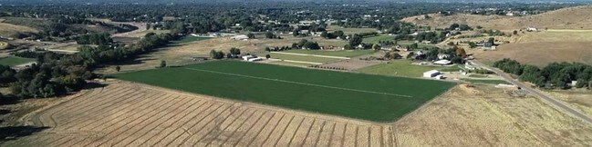
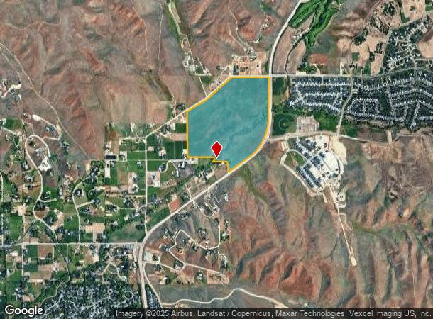
Property Record
13405 N Horseshoe Bend Rd, Boise, ID 83714
NEARBY LISTINGS FOR SALE OR LEASE
Property Detail
13405 N Horseshoe Bend Rd
S0235212430
PAR #2430 OF W2 SEC 35 5N 1E #212426-B
Agriculturalland
Ada
AE
Idaho
16001C0156H
135.18 AC
2024
North Ada County
2025
Boise City/Nampa
010230
Boise City, ID
1,260 SF
DEMOGRAPHICS near 13405 N Horseshoe Bend Rd
1 Mile
3 Mile
5 Mile
2024 Total Population
812
15,094
47,586
2029 Population
958
17,228
54,324
Pop Growth 2024-2029
+ 17.98%
+ 14.14%
+ 14.16%
Average Age
43
43
44
2024 Total Households
294
5,451
18,671
HH Growth 2024-2029
+ 18.03%
+ 14.40%
+ 14.40%
Median Household Inc
$96,917
$107,161
$96,267
Avg Household Size
2.80
2.70
2.50
2024 Avg HH Vehicles
2.00
2.00
2.00
Median Home Value
$567,982
$571,787
$560,830
Median Year Built
1997
1998
2001
Nearby Places
Map Layers
Map Styles
 Street
 Aerial
- Restaurants
- Banks
- Shops
- Fitness
- Groceries
PUBLIC TRANSPORTATION
AIRPORT
Boise Air Trml/Gowen Field
DRIVE
WALK
Distance
Boise Air Trml/Gowen Field
42 min
18.7 mi
Freight Ports
Port of Portland
DRIVE
WALK
Distance
Port of Portland
477 min
429.1 mi
SALE & LEASE HISTORY
LISTING DATE
SALE/LEASE

Sep 03, 2019
For Sale
Nearby Properties
Address
Land Use
TOTAL SIZE
Lot Size
Zoning
Address
Land Use
TOTAL SIZE
Lot Size
Zoning
36,454 SF
3.18 AC
MU
Address
Land Use
TOTAL SIZE
Lot Size
Zoning
165,295 SF
7.01 AC
MU-DA
Address
Land Use
TOTAL SIZE
Lot Size
Zoning
74,296 SF
4.86 AC
CBD
Address
Land Use
TOTAL SIZE
Lot Size
Zoning
112,281 SF
9.72 AC
C-3
Address
Land Use
TOTAL SIZE
Lot Size
Zoning
104,886 SF
12.51 AC
C-3
Address
Land Use
TOTAL SIZE
Lot Size
Zoning
12.71 AC
C-3
Address
Land Use
TOTAL SIZE
Lot Size
Zoning
183,445 SF
13.62 AC
BP
Address
Land Use
TOTAL SIZE
Lot Size
Zoning
54,604 SF
2.72 AC
MU-DA
Address
Land Use
TOTAL SIZE
Lot Size
Zoning
52,800 SF
3.70 AC
C-2
Address
Land Use
TOTAL SIZE
Lot Size
Zoning
112,746 SF
3.65 AC
MU
Address
Land Use
TOTAL SIZE
Lot Size
Zoning
11.62 AC
R6
Address
Land Use
TOTAL SIZE
Lot Size
Zoning
7.92 AC
CBD
Address
Land Use
TOTAL SIZE
Lot Size
Zoning
72,724 SF
4.10 AC
BP-DA
Address
Land Use
TOTAL SIZE
Lot Size
Zoning
21,744 SF
1.88 AC
MU
Address
Land Use
TOTAL SIZE
Lot Size
Zoning
59,292 SF
3.51 AC
MU-DA
Address
Land Use
TOTAL SIZE
Lot Size
Zoning
14,708 SF
2.14 AC
MU
Address
Land Use
TOTAL SIZE
Lot Size
Zoning
64,968 SF
4.97 AC
BP
Address
Land Use
TOTAL SIZE
Lot Size
Zoning
28,124 SF
2 AC
M-1
Address
Land Use
TOTAL SIZE
Lot Size
Zoning
6,264 SF
1.11 AC
C-1-DA
Address
Land Use
TOTAL SIZE
Lot Size
Zoning
22,500 SF
1.61 AC
M-1
Address
Land Use
TOTAL SIZE
Lot Size
Zoning
21,174 SF
1 AC
PC
Address
Land Use
TOTAL SIZE
Lot Size
Zoning
30,021 SF
1.80 AC
MU-DA
Address
Land Use
TOTAL SIZE
Lot Size
Zoning
16,128 SF
1.61 AC
MU
Address
Land Use
TOTAL SIZE
Lot Size
Zoning
12,395 SF
1.45 AC
C-3
Address
Land Use
TOTAL SIZE
Lot Size
Zoning
49,997 SF
0.67 AC
MU-DA
Address
Land Use
TOTAL SIZE
Lot Size
Zoning
25.92 AC
MU-DA
Address
Land Use
TOTAL SIZE
Lot Size
Zoning
18,780 SF
1.65 AC
CBD
Address
Land Use
TOTAL SIZE
Lot Size
Zoning
14,098 SF
2 AC
MU
Address
Land Use
TOTAL SIZE
Lot Size
Zoning
9,856 SF
10 AC
RR
Address
Land Use
TOTAL SIZE
Lot Size
Zoning
13,691 SF
136.87 AC
RR
The World's #1 Commercial Real Estate Marketplace
Connect with us
© 2025 CoStar Group
The information above has been obtained from sources believed reliable. While we do not doubt its accuracy we have not verified it and make no guarantee, warranty or representation about it. It is your responsibility to independently confirm its accuracy and completeness. Any projections, opinions, assumptions, or estimates used are for example only and do not represent the current or future performance of the property. The value of this transaction to you depends on tax and other factors which should be evaluated by your tax, financial, and legal advisors. You and your advisors should conduct a careful, independent investigation of the property to determine to your satisfaction the suitability of the property for your needs.