Property Record
13411 Hidden Palms Cv, Fort Myers, FL 33908
NEARBY LISTINGS FOR SALE OR LEASE
Property Detail
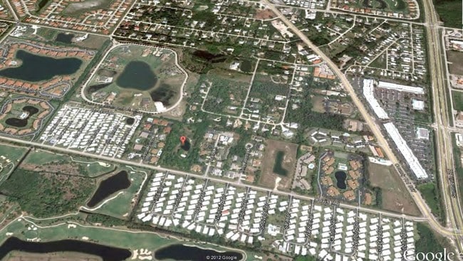
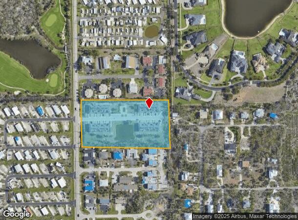
13411 Hidden Palms Cv
Cape Coral-Fort Myers, FL
Mcgregor / Summerlin
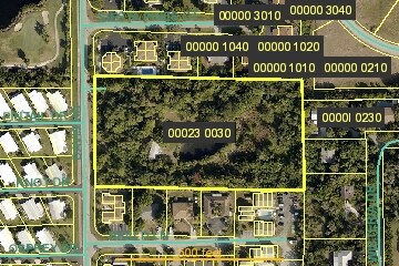
02-46-23-00-00023.0030
TH N 1/2 OF NE 1/4 OF NE 1/4 OF SW 1/4
Multifamilydwelling
Lee
AE
Florida
12071C0413G
3
2024
4.86 AC
2025
S Ft Myers/San Carlos
001923
Southwest Florida
45,744 SF
DEMOGRAPHICS near 13411 Hidden Palms Cv
1 Mile
3 Mile
5 Mile
2024 Total Population
5,801
26,887
81,626
2029 Population
6,936
32,345
98,084
Pop Growth 2024-2029
+ 19.57%
+ 20.30%
+ 20.16%
Average Age
63
62
56
2024 Total Households
2,875
14,227
40,407
HH Growth 2024-2029
+ 19.34%
+ 20.00%
+ 19.88%
Median Household Inc
$44,725
$57,871
$62,768
Avg Household Size
1.80
1.80
1.90
2024 Avg HH Vehicles
1.00
1.00
1.00
Median Home Value
$302,778
$282,562
$332,645
Median Year Built
1988
1989
1991
Nearby Places
- Restaurants
- Banks
- Shops
- Fitness
- Groceries
PUBLIC TRANSPORTATION
AIRPORT
Southwest Florida International
DRIVE
WALK
Distance
Southwest Florida International
30 min
17.3 mi
Punta Gorda
DRIVE
WALK
Distance
Punta Gorda
59 min
43.4 mi
Freight Ports
Port Manatee
DRIVE
WALK
Distance
Port Manatee
138 min
115.1 mi
Nearby Properties
Address
Land Use
TOTAL SIZE
Lot Size
Zoning
Address
Land Use
TOTAL SIZE
Lot Size
Zoning
4,442,296 SF
162.17 AC
RM-2
Address
Land Use
TOTAL SIZE
Lot Size
Zoning
446,205 SF
28.90 AC
CC
Address
Land Use
TOTAL SIZE
Lot Size
Zoning
334,148 SF
48.67 AC
RM-2
Address
Land Use
TOTAL SIZE
Lot Size
Zoning
335,660 SF
15.42 AC
MPD
Address
Land Use
TOTAL SIZE
Lot Size
Zoning
224,965 SF
21.13 AC
EC
Address
Land Use
TOTAL SIZE
Lot Size
Zoning
4,739 SF
17.92 AC
EC+CF
Address
Land Use
TOTAL SIZE
Lot Size
Zoning
235,691 SF
30.01 AC
RM-6
Address
Land Use
TOTAL SIZE
Lot Size
Zoning
106,730 SF
2.36 AC
CPD
Address
Land Use
TOTAL SIZE
Lot Size
Zoning
15.22 AC
CF-3
Address
Land Use
TOTAL SIZE
Lot Size
Zoning
84,147 SF
10.60 AC
CPD
Address
Land Use
TOTAL SIZE
Lot Size
Zoning
120,368 SF
3.52 AC
CPD
Address
Land Use
TOTAL SIZE
Lot Size
Zoning
5,654 SF
49.94 AC
MH-2
Address
Land Use
TOTAL SIZE
Lot Size
Zoning
132,456 SF
7.86 AC
IPD
Address
Land Use
TOTAL SIZE
Lot Size
Zoning
38,928 SF
4.88 AC
CT
Address
Land Use
TOTAL SIZE
Lot Size
Zoning
44.05 AC
RPD
Address
Land Use
TOTAL SIZE
Lot Size
Zoning
87,275 SF
10.79 AC
CPD
Address
Land Use
TOTAL SIZE
Lot Size
Zoning
85,815 SF
3.48 AC
CT
Address
Land Use
TOTAL SIZE
Lot Size
Zoning
185,986 SF
13.40 AC
CPD
Address
Land Use
TOTAL SIZE
Lot Size
Zoning
82,450 SF
4.11 AC
CPD
Address
Land Use
TOTAL SIZE
Lot Size
Zoning
59,183 SF
7.16 AC
CPD
Address
Land Use
TOTAL SIZE
Lot Size
Zoning
111,756 SF
2.78 AC
CPD
Address
Land Use
TOTAL SIZE
Lot Size
Zoning
163,409 SF
15.13 AC
CG
Address
Land Use
TOTAL SIZE
Lot Size
Zoning
34,689 SF
6.03 AC
CPD
Address
Land Use
TOTAL SIZE
Lot Size
Zoning
168,737 SF
20.28 AC
CC
Address
Land Use
TOTAL SIZE
Lot Size
Zoning
49,378 SF
2 AC
CPD
Address
Land Use
TOTAL SIZE
Lot Size
Zoning
33,910 SF
3.33 AC
RPD
Address
Land Use
TOTAL SIZE
Lot Size
Zoning
44,117 SF
9.41 AC
CFPD
Address
Land Use
TOTAL SIZE
Lot Size
Zoning
102,031 SF
4.01 AC
MPD
Address
Land Use
TOTAL SIZE
Lot Size
Zoning
61,941 SF
5.95 AC
CC
Address
Land Use
TOTAL SIZE
Lot Size
Zoning
60,546 SF
9.97 AC
RM-2
The World's #1 Commercial Real Estate Marketplace
Connect with us
© 2025 CoStar Group
The information above has been obtained from sources believed reliable. While we do not doubt its accuracy we have not verified it and make no guarantee, warranty or representation about it. It is your responsibility to independently confirm its accuracy and completeness. Any projections, opinions, assumptions, or estimates used are for example only and do not represent the current or future performance of the property. The value of this transaction to you depends on tax and other factors which should be evaluated by your tax, financial, and legal advisors. You and your advisors should conduct a careful, independent investigation of the property to determine to your satisfaction the suitability of the property for your needs.