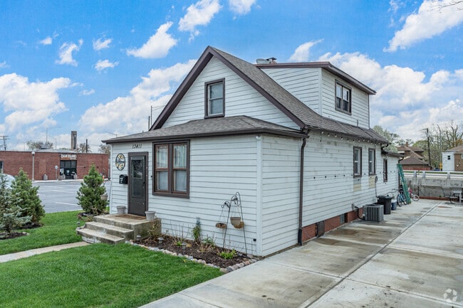
Property Record
13411 Western Ave, Blue Island, IL 60406

NEARBY LISTINGS FOR SALE OR LEASE
Property Detail
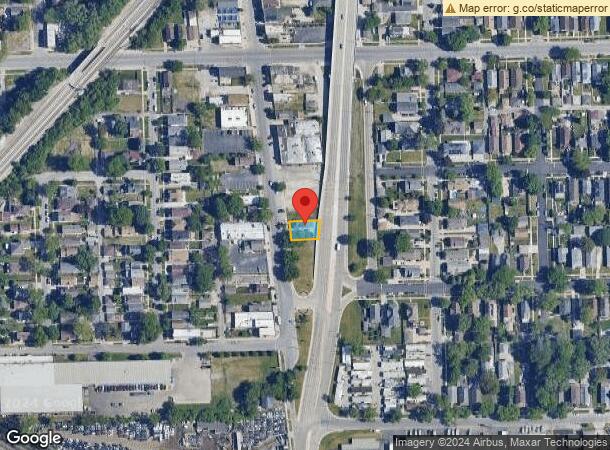
13411 Western Ave
Chicago-Naperville-Elgin, IL-IN-WI
Robinsons Sub
24-36-433-020-0000
Cook
Sfr
Illinois
X
0.10 AC
17031C0643J
Near South Cook
980 SF
Chicago
DEMOGRAPHICS near 13411 Western Ave
1 Mile
3 Mile
5 Mile
2024 Total Population
12,449
119,655
337,234
2029 Population
12,244
118,000
331,033
Pop Growth 2024-2029
(1.65%)
(1.38%)
(1.84%)
Average Age
37
40
40
2024 Total Households
4,526
44,314
125,814
HH Growth 2024-2029
(1.99%)
(1.67%)
(2.13%)
Median Household Inc
$46,382
$49,872
$56,776
Avg Household Size
2.70
2.60
2.60
2024 Avg HH Vehicles
1.00
2.00
2.00
Median Home Value
$141,887
$147,439
$176,148
Median Year Built
1957
1961
1959
Nearby Places
Map Layers
Map Styles
 Street
 Aerial
- Restaurants
- Banks
- Shops
- Fitness
- Groceries
PUBLIC TRANSPORTATION
COMMUTER RAIL
Blue Island - Vermont Street Station (Metra Electric Line - Northeast Illinois Regional Commuter Railroad (Metra), Rock Island District Line - Northeast Illinois Regional Commuter Railroad (Metra))
DRIVE
WALK
Distance
Blue Island - Vermont Street Station (Metra Electric Line - Northeast Illinois Regional Commuter Railroad (Metra), Rock Island District Line - Northeast Illinois Regional Commuter Railroad (Metra))
2 min
14 min
0.7 mi
Robbins Station (Rock Island District Line - Northeast Illinois Regional Commuter Railroad (Metra))
DRIVE
WALK
Distance
Robbins Station (Rock Island District Line - Northeast Illinois Regional Commuter Railroad (Metra))
3 min
1.3 mi
AIRPORT
Chicago Midway International
DRIVE
WALK
Distance
Chicago Midway International
23 min
13.8 mi
Chicago O'Hare International
DRIVE
WALK
Distance
Chicago O'Hare International
50 min
35.8 mi
Freight Ports
Port Milwaukee
DRIVE
WALK
Distance
Port Milwaukee
131 min
107.5 mi
SALE & LEASE HISTORY
LISTING DATE
SALE/LEASE

Jun 03, 2024
For Lease
Nearby Properties
Address
Land Use
TOTAL SIZE
Lot Size
Zoning
Address
Land Use
TOTAL SIZE
Lot Size
Zoning
8 AC
PD 1168
Address
Land Use
TOTAL SIZE
Lot Size
Zoning
0.51 AC
PD 1168
Address
Land Use
TOTAL SIZE
Lot Size
Zoning
1.08 AC
PD 1168
Address
Land Use
TOTAL SIZE
Lot Size
Zoning
11 AC
PD 1168
Address
Land Use
TOTAL SIZE
Lot Size
Zoning
307,335 SF
24.17 AC
PD 770
Address
Land Use
TOTAL SIZE
Lot Size
Zoning
88,008 SF
3.96 AC
Address
Land Use
TOTAL SIZE
Lot Size
Zoning
63,930 SF
3.49 AC
PD 181
Address
Land Use
TOTAL SIZE
Lot Size
Zoning
Address
Land Use
TOTAL SIZE
Lot Size
Zoning
83,005 SF
3.11 AC
Address
Land Use
TOTAL SIZE
Lot Size
Zoning
380,924 SF
19.13 AC
Address
Land Use
TOTAL SIZE
Lot Size
Zoning
421,052 SF
26.15 AC
Address
Land Use
TOTAL SIZE
Lot Size
Zoning
152,306 SF
13.40 AC
Address
Land Use
TOTAL SIZE
Lot Size
Zoning
129,837 SF
10.44 AC
PD 770
Address
Land Use
TOTAL SIZE
Lot Size
Zoning
185,748 SF
15.30 AC
Address
Land Use
TOTAL SIZE
Lot Size
Zoning
405,045 SF
14.49 AC
Address
Land Use
TOTAL SIZE
Lot Size
Zoning
Address
Land Use
TOTAL SIZE
Lot Size
Zoning
Address
Land Use
TOTAL SIZE
Lot Size
Zoning
98,506 SF
7.66 AC
Address
Land Use
TOTAL SIZE
Lot Size
Zoning
105,150 SF
4 AC
Address
Land Use
TOTAL SIZE
Lot Size
Zoning
Address
Land Use
TOTAL SIZE
Lot Size
Zoning
162,379 SF
10.59 AC
Address
Land Use
TOTAL SIZE
Lot Size
Zoning
Address
Land Use
TOTAL SIZE
Lot Size
Zoning
8,800 SF
8.83 AC
Address
Land Use
TOTAL SIZE
Lot Size
Zoning
9.38 AC
Address
Land Use
TOTAL SIZE
Lot Size
Zoning
451,400 SF
26.59 AC
M3-3
Address
Land Use
TOTAL SIZE
Lot Size
Zoning
1.91 AC
Address
Land Use
TOTAL SIZE
Lot Size
Zoning
121,968 SF
13.31 AC
Address
Land Use
TOTAL SIZE
Lot Size
Zoning
1.71 AC
PD 1168
Address
Land Use
TOTAL SIZE
Lot Size
Zoning
132,322 SF
2 AC
Address
Land Use
TOTAL SIZE
Lot Size
Zoning
109,213 SF
7.59 AC
The World's #1 Commercial Real Estate Marketplace
Connect with us
© 2026 CoStar Group
The information above has been obtained from sources believed reliable. While we do not doubt its accuracy we have not verified it and make no guarantee, warranty or representation about it. It is your responsibility to independently confirm its accuracy and completeness. Any projections, opinions, assumptions, or estimates used are for example only and do not represent the current or future performance of the property. The value of this transaction to you depends on tax and other factors which should be evaluated by your tax, financial, and legal advisors. You and your advisors should conduct a careful, independent investigation of the property to determine to your satisfaction the suitability of the property for your needs.