Property Record
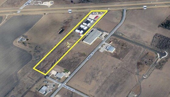
13419 Us Highway 290 E, Manor, TX 78653

Property Detail
13419 Us Highway 290 E
814602
ABS 154 SUR 52 CALDWELL A C ACR 10.01
Warehouse
Travis
B and X Area of moderate flood hazard, usually the area between the limits of the 100-year and 500-year floods.
Texas
2025
10.01 AC
2025
East
002217
Austin
23,551 SF
Austin-Round Rock-San Marcos, TX
NEARBY LISTINGS FOR SALE OR LEASE
DEMOGRAPHICS near 13419 Us Highway 290 E
1 mile
3 mile
5 mile
2025 Total Population
8,363
29,140
37,938
2030 Population
8,945
31,271
40,754
Pop Growth 2025-2030
+ 6.96%
+ 7.31%
+ 7.42%
Average Age
34
35
36
2025 Total Households
2,594
9,223
11,948
HH Growth 2025-2030
+ 7.59%
+ 8.05%
+ 8.18%
Median Household Inc
$88,616
$93,248
$94,574
Avg Household Size
3.20
3.10
3.20
2025 Avg HH Vehicles
2.00
2.00
2.00
Median Home Value
$345,662
$353,961
$357,432
Median Year Built
2011
2010
2010
Nearby Places
Map Layers
Map Styles
 Street
 Aerial
Transit
 Traffic
 Biking
Places
Listings with unknown addresses are not visible on the map
- Restaurants
- Banks
- Shops
- Fitness
- Groceries
PUBLIC TRANSPORTATION
AIRPORT
Austin-Bergstrom International
Drive
Walk
Distance
Austin-Bergstrom International
32 min
21.0 mi
SALE & LEASE HISTORY
LISTING DATE
SALE/LEASE

Sep 24, 2016
For Sale
Oct 17, 2018
For Sale
Nearby Properties
Address
Land Use
TOTAL SIZE
Lot Size
Zoning
Address
Land Use
TOTAL SIZE
Lot Size
Zoning
264,000 SF
14.22 AC
Address
Land Use
TOTAL SIZE
Lot Size
Zoning
300,492 SF
13.20 AC
Address
Land Use
TOTAL SIZE
Lot Size
Zoning
266,564 SF
27.40 AC
Address
Land Use
TOTAL SIZE
Lot Size
Zoning
204,356 SF
12.18 AC
Address
Land Use
TOTAL SIZE
Lot Size
Zoning
149,640 SF
10.39 AC
Address
Land Use
TOTAL SIZE
Lot Size
Zoning
248,325 SF
14.73 AC
Address
Land Use
TOTAL SIZE
Lot Size
Zoning
111,966 SF
11.61 AC
Address
Land Use
TOTAL SIZE
Lot Size
Zoning
109,184 SF
13.45 AC
Address
Land Use
TOTAL SIZE
Lot Size
Zoning
147,908 SF
15.54 AC
Address
Land Use
TOTAL SIZE
Lot Size
Zoning
200.38 AC
Address
Land Use
TOTAL SIZE
Lot Size
Zoning
236.07 AC
Address
Land Use
TOTAL SIZE
Lot Size
Zoning
51,910 SF
13.19 AC
Address
Land Use
TOTAL SIZE
Lot Size
Zoning
100,100 SF
8.52 AC
Address
Land Use
TOTAL SIZE
Lot Size
Zoning
67,410 SF
7 AC
Address
Land Use
TOTAL SIZE
Lot Size
Zoning
136.34 AC
Address
Land Use
TOTAL SIZE
Lot Size
Zoning
25,495 SF
5.95 AC
Address
Land Use
TOTAL SIZE
Lot Size
Zoning
71,436 SF
8 AC
Address
Land Use
TOTAL SIZE
Lot Size
Zoning
52,500 SF
5.47 AC
Address
Land Use
TOTAL SIZE
Lot Size
Zoning
35,016 SF
4.27 AC
Address
Land Use
TOTAL SIZE
Lot Size
Zoning
49,062 SF
1.97 AC
Address
Land Use
TOTAL SIZE
Lot Size
Zoning
12.08 AC
Address
Land Use
TOTAL SIZE
Lot Size
Zoning
26,183 SF
0.66 AC
Address
Land Use
TOTAL SIZE
Lot Size
Zoning
21,961 SF
7.88 AC
Address
Land Use
TOTAL SIZE
Lot Size
Zoning
44,217 SF
19.69 AC
Address
Land Use
TOTAL SIZE
Lot Size
Zoning
60,210 SF
5.09 AC
Address
Land Use
TOTAL SIZE
Lot Size
Zoning
14,640 SF
69.10 AC
Address
Land Use
TOTAL SIZE
Lot Size
Zoning
20.03 AC
Address
Land Use
TOTAL SIZE
Lot Size
Zoning
30,000 SF
0.78 AC
Address
Land Use
TOTAL SIZE
Lot Size
Zoning
18.08 AC
Address
Land Use
TOTAL SIZE
Lot Size
Zoning
49,372 SF
6.32 AC
The World's #1 Commercial Real Estate Marketplace
Connect with us
© 2026 CoStar Group
The information above has been obtained from sources believed reliable. While we do not doubt its accuracy we have not verified it and make no guarantee, warranty or representation about it. It is your responsibility to independently confirm its accuracy and completeness. Any projections, opinions, assumptions, or estimates used are for example only and do not represent the current or future performance of the property. The value of this transaction to you depends on tax and other factors which should be evaluated by your tax, financial, and legal advisors. You and your advisors should conduct a careful, independent investigation of the property to determine to your satisfaction the suitability of the property for your needs.