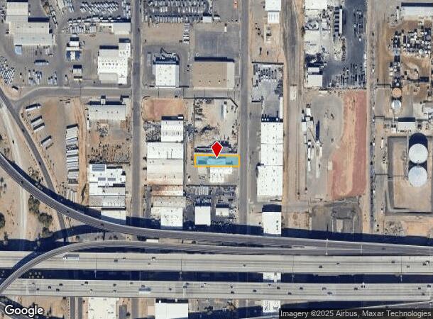
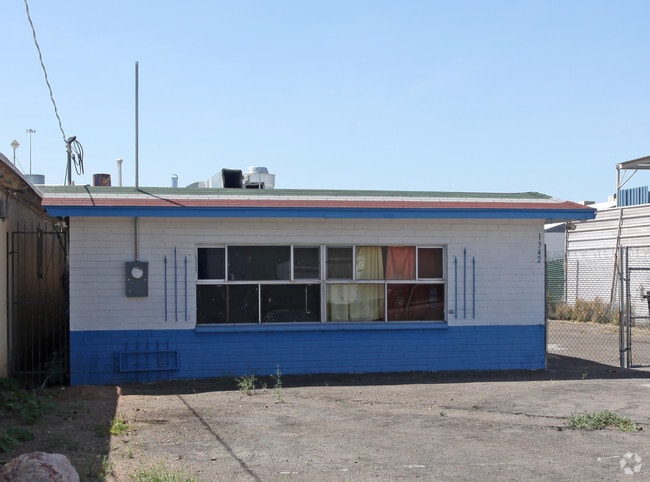
Property Record
1342 N 21St Ave, Phoenix, AZ 85009

Current Lease Availabilities
NEARBY LISTINGS FOR SALE OR LEASE
Property Detail
1342 N 21St Ave
Phoenix-Mesa-Scottsdale, AZ
Central Industrial Dist.
109-02-003B
CENTRAL INDUSTRIAL DIST. MCR 42/25
Restaurantbuilding
Maricopa
X
Arizona
04013C2205L
3
2025
0.23 AC
2025
Downtown Phoenix
116800
Phoenix
1,625 SF
DEMOGRAPHICS near 1342 N 21St Ave
1 Mile
3 Mile
5 Mile
2024 Total Population
7,441
147,645
383,940
2029 Population
8,002
160,377
415,579
Pop Growth 2024-2029
+ 7.54%
+ 8.62%
+ 8.24%
Average Age
37
35
35
2024 Total Households
2,886
56,810
136,821
HH Growth 2024-2029
+ 7.66%
+ 9.29%
+ 8.81%
Median Household Inc
$55,608
$48,842
$51,257
Avg Household Size
2.40
2.40
2.60
2024 Avg HH Vehicles
2.00
1.00
2.00
Median Home Value
$439,444
$312,662
$296,596
Median Year Built
1955
1968
1970
Nearby Places
Map Layers
Map Styles
 Street
 Aerial
- Restaurants
- Banks
- Shops
- Fitness
- Groceries
PUBLIC TRANSPORTATION
AIRPORT
Phoenix Sky Harbor International
DRIVE
WALK
Distance
Phoenix Sky Harbor International
14 min
8.4 mi
Phoenix-Mesa Gateway
DRIVE
WALK
Distance
Phoenix-Mesa Gateway
48 min
35.6 mi
Nearby Properties
Address
Land Use
TOTAL SIZE
Lot Size
Zoning
Address
Land Use
TOTAL SIZE
Lot Size
Zoning
582,073 SF
1.45 AC
C-C
Address
Land Use
TOTAL SIZE
Lot Size
Zoning
1.85 AC
Address
Land Use
TOTAL SIZE
Lot Size
Zoning
455,443 SF
3.21 AC
C-C
Address
Land Use
TOTAL SIZE
Lot Size
Zoning
997,436 SF
24.84 AC
DC
Address
Land Use
TOTAL SIZE
Lot Size
Zoning
339,909 SF
3 AC
C-C
Address
Land Use
TOTAL SIZE
Lot Size
Zoning
2,568,761 SF
48.36 AC
C-C
Address
Land Use
TOTAL SIZE
Lot Size
Zoning
270,000 SF
12.90 AC
I-1
Address
Land Use
TOTAL SIZE
Lot Size
Zoning
437,102 SF
1.02 AC
C-2
Address
Land Use
TOTAL SIZE
Lot Size
Zoning
2,334,671 SF
32.63 AC
C-2
Address
Land Use
TOTAL SIZE
Lot Size
Zoning
191,120 SF
1.43 AC
C-C
Address
Land Use
TOTAL SIZE
Lot Size
Zoning
1,636,025 SF
16.50 AC
C-DT
Address
Land Use
TOTAL SIZE
Lot Size
Zoning
577,883 SF
2.05 AC
C-DT
Address
Land Use
TOTAL SIZE
Lot Size
Zoning
568,512 SF
6.99 AC
C-DT
Address
Land Use
TOTAL SIZE
Lot Size
Zoning
671,803 SF
2.99 AC
C-DT
Address
Land Use
TOTAL SIZE
Lot Size
Zoning
1,378,775 SF
86.09 AC
M-H
Address
Land Use
TOTAL SIZE
Lot Size
Zoning
833,326 SF
1.31 AC
C-DT
Address
Land Use
TOTAL SIZE
Lot Size
Zoning
940,067 SF
12.22 AC
DTCBIO
Address
Land Use
TOTAL SIZE
Lot Size
Zoning
536,452 SF
0.58 AC
C-DT
Address
Land Use
TOTAL SIZE
Lot Size
Zoning
91,000 SF
7.57 AC
I-1
Address
Land Use
TOTAL SIZE
Lot Size
Zoning
981,015 SF
2.83 AC
C-DT
Address
Land Use
TOTAL SIZE
Lot Size
Zoning
429,457 SF
9.41 AC
C-DT
Address
Land Use
TOTAL SIZE
Lot Size
Zoning
384,291 SF
2.68 AC
C-DT
Address
Land Use
TOTAL SIZE
Lot Size
Zoning
782,912 SF
1.12 AC
C-DT
Address
Land Use
TOTAL SIZE
Lot Size
Zoning
550,269 SF
2.05 AC
DTCBCORE
Address
Land Use
TOTAL SIZE
Lot Size
Zoning
727,848 SF
0.06 AC
C-DT
Address
Land Use
TOTAL SIZE
Lot Size
Zoning
569,100 SF
0.95 AC
C-DT
Address
Land Use
TOTAL SIZE
Lot Size
Zoning
222,983 SF
1.61 AC
C-DT
Address
Land Use
TOTAL SIZE
Lot Size
Zoning
686,094 SF
5.09 AC
C-C
Address
Land Use
TOTAL SIZE
Lot Size
Zoning
440,160 SF
42.43 AC
A1
Address
Land Use
TOTAL SIZE
Lot Size
Zoning
610,451 SF
4.21 AC
C-C
The World's #1 Commercial Real Estate Marketplace
Connect with us
© 2025 CoStar Group
The information above has been obtained from sources believed reliable. While we do not doubt its accuracy we have not verified it and make no guarantee, warranty or representation about it. It is your responsibility to independently confirm its accuracy and completeness. Any projections, opinions, assumptions, or estimates used are for example only and do not represent the current or future performance of the property. The value of this transaction to you depends on tax and other factors which should be evaluated by your tax, financial, and legal advisors. You and your advisors should conduct a careful, independent investigation of the property to determine to your satisfaction the suitability of the property for your needs.