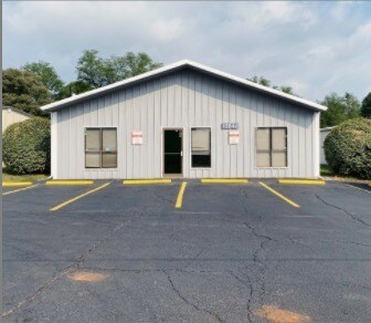
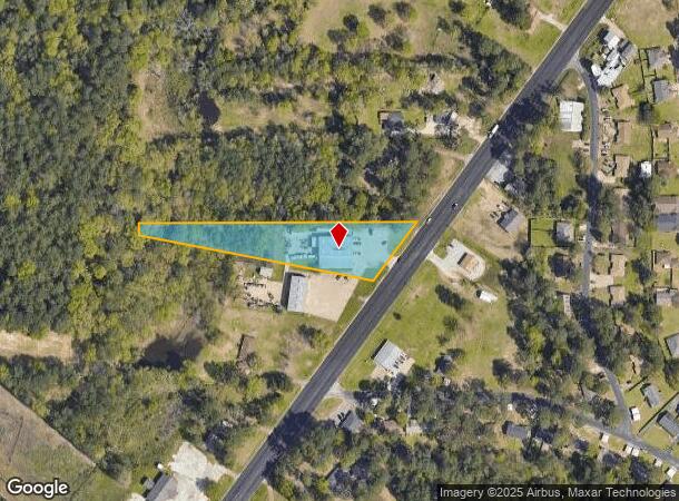
Property Record
13420 State Highway 155 S, Tyler, TX 75703
NEARBY LISTINGS FOR SALE OR LEASE
Property Detail
13420 State Highway 155 S
1-00000-0018-07-012050
A0018 T Quevado
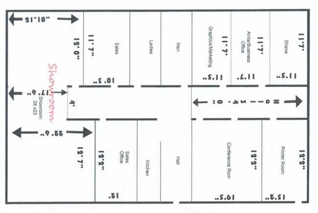
Warehouse
ABST A0018 T QUEVADOTRACT 12E
X
Smith
48423C0365D
Texas
2024
2.06 AC
2025
Tyler & Longview
001917
Other Market Areas
9,000 SF
Tyler, TX
DEMOGRAPHICS near 13420 State Highway 155 S
1 Mile
3 Mile
5 Mile
2024 Total Population
1,646
28,072
73,867
2029 Population
1,853
30,621
80,197
Pop Growth 2024-2029
+ 12.58%
+ 9.08%
+ 8.57%
Average Age
44
41
40
2024 Total Households
636
12,611
30,764
HH Growth 2024-2029
+ 12.42%
+ 8.52%
+ 8.00%
Median Household Inc
$67,357
$63,405
$65,498
Avg Household Size
2.40
2.20
2.30
2024 Avg HH Vehicles
2.00
2.00
2.00
Median Home Value
$329,487
$281,550
$236,611
Median Year Built
2005
1995
1985
Nearby Places
Map Layers
Map Styles
 Street
 Aerial
- Restaurants
- Banks
- Shops
- Fitness
- Groceries
PUBLIC TRANSPORTATION
AIRPORT
Tyler Pounds Regional
DRIVE
WALK
Distance
Tyler Pounds Regional
17 min
10.4 mi
Freight Ports
Port of Shreveport
DRIVE
WALK
Distance
Port of Shreveport
129 min
114.1 mi
SALE & LEASE HISTORY
LISTING DATE
SALE/LEASE

Oct 19, 2020
For Lease
Mar 30, 2017
For Lease
Mar 29, 2022
For Lease
Mar 25, 2025
For Lease
Nearby Properties
Address
Land Use
TOTAL SIZE
Lot Size
Zoning
Address
Land Use
TOTAL SIZE
Lot Size
Zoning
11,332 SF
22.07 AC
PMF
Address
Land Use
TOTAL SIZE
Lot Size
Zoning
7,152 SF
19.76 AC
RMF
Address
Land Use
TOTAL SIZE
Lot Size
Zoning
29.58 AC
Address
Land Use
TOTAL SIZE
Lot Size
Zoning
234,762 SF
16.68 AC
Address
Land Use
TOTAL SIZE
Lot Size
Zoning
5,068 SF
18.35 AC
RMF
Address
Land Use
TOTAL SIZE
Lot Size
Zoning
4,333 SF
13.32 AC
Address
Land Use
TOTAL SIZE
Lot Size
Zoning
3,149 SF
16.15 AC
RMF
Address
Land Use
TOTAL SIZE
Lot Size
Zoning
4,349 SF
33.26 AC
RMF
Address
Land Use
TOTAL SIZE
Lot Size
Zoning
237,916 SF
11.17 AC
PMF
Address
Land Use
TOTAL SIZE
Lot Size
Zoning
10.51 AC
Address
Land Use
TOTAL SIZE
Lot Size
Zoning
1,867 SF
13.63 AC
RMF
Address
Land Use
TOTAL SIZE
Lot Size
Zoning
3,968 SF
12.04 AC
RMF
Address
Land Use
TOTAL SIZE
Lot Size
Zoning
126.94 AC
Address
Land Use
TOTAL SIZE
Lot Size
Zoning
3,538 SF
9.51 AC
RMF
Address
Land Use
TOTAL SIZE
Lot Size
Zoning
90,410 SF
4.94 AC
Address
Land Use
TOTAL SIZE
Lot Size
Zoning
3,806 SF
18.86 AC
RMF
Address
Land Use
TOTAL SIZE
Lot Size
Zoning
3,477 SF
9.56 AC
RMF
Address
Land Use
TOTAL SIZE
Lot Size
Zoning
2,936 SF
9.66 AC
RMF
Address
Land Use
TOTAL SIZE
Lot Size
Zoning
17,912 SF
9.06 AC
RMF
Address
Land Use
TOTAL SIZE
Lot Size
Zoning
40,960 SF
8.90 AC
RMF
Address
Land Use
TOTAL SIZE
Lot Size
Zoning
19.16 AC
Address
Land Use
TOTAL SIZE
Lot Size
Zoning
105,407 SF
6.14 AC
C4
Address
Land Use
TOTAL SIZE
Lot Size
Zoning
34,758 SF
9.76 AC
Address
Land Use
TOTAL SIZE
Lot Size
Zoning
15,400 SF
4.41 AC
RMF
Address
Land Use
TOTAL SIZE
Lot Size
Zoning
207,849 SF
24.89 AC
Address
Land Use
TOTAL SIZE
Lot Size
Zoning
1,821 SF
8.95 AC
RMF
Address
Land Use
TOTAL SIZE
Lot Size
Zoning
23,796 SF
10.88 AC
RMF
Address
Land Use
TOTAL SIZE
Lot Size
Zoning
13.73 AC
INT
Address
Land Use
TOTAL SIZE
Lot Size
Zoning
85,357 SF
3.17 AC
Address
Land Use
TOTAL SIZE
Lot Size
Zoning
109,616 SF
7.02 AC
The World's #1 Commercial Real Estate Marketplace
Connect with us
© 2025 CoStar Group
The information above has been obtained from sources believed reliable. While we do not doubt its accuracy we have not verified it and make no guarantee, warranty or representation about it. It is your responsibility to independently confirm its accuracy and completeness. Any projections, opinions, assumptions, or estimates used are for example only and do not represent the current or future performance of the property. The value of this transaction to you depends on tax and other factors which should be evaluated by your tax, financial, and legal advisors. You and your advisors should conduct a careful, independent investigation of the property to determine to your satisfaction the suitability of the property for your needs.