Property Record
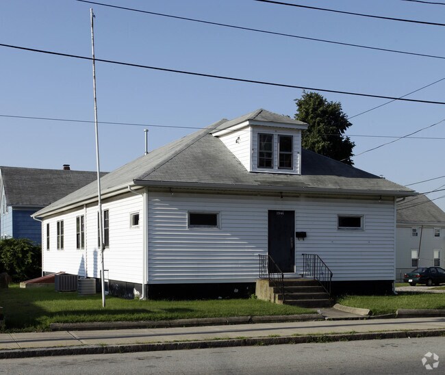
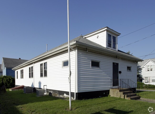
1344 Cranston St, Cranston, RI 02920

Property Detail
1344 Cranston St
CRAN-000008-000002-000478
Providence
Charitableorganization
Rhode Island
C2
478
B and X Area of moderate flood hazard, usually the area between the limits of the 100-year and 500-year floods.
0.11 AC
0
Cranston
2025
Providence
014700
Providence-Warwick, RI-MA
3,075 SF
NEARBY LISTINGS FOR SALE OR LEASE
DEMOGRAPHICS near 1344 Cranston St
1 mile
3 mile
5 mile
2025 Total Population
16,937
177,575
353,188
2030 Population
17,349
181,827
362,978
Pop Growth 2025-2030
+ 2.43%
+ 2.39%
+ 2.77%
Average Age
40
38
39
2025 Total Households
6,780
68,192
139,028
HH Growth 2025-2030
+ 2.45%
+ 2.57%
+ 2.97%
Median Household Inc
$64,438
$69,070
$74,244
Avg Household Size
2.40
2.50
2.40
2025 Avg HH Vehicles
2.00
1.00
2.00
Median Home Value
$334,401
$348,678
$365,917
Median Year Built
1952
1950
1952
Nearby Places
Map Layers
Map Styles
 Street
 Aerial
Layers
 Traffic
 Biking
Places
Listings with unknown addresses are not visible on the map
- Restaurants
- Banks
- Shops
- Fitness
- Groceries
PUBLIC TRANSPORTATION
COMMUTER RAIL
Providence (Providence/Stoughton Line - Massachusetts Bay Transportation Authority Commuter Rail (Purple Line))
Drive
Walk
Distance
Providence (Providence/Stoughton Line - Massachusetts Bay Transportation Authority Commuter Rail (Purple Line))
7 min
4.2 mi
Drive
Walk
Distance
13 min
6.7 mi
AIRPORT
Rhode Island Tf Green International
Drive
Walk
Distance
Rhode Island Tf Green International
17 min
7.5 mi
Worcester Regional
Drive
Walk
Distance
Worcester Regional
64 min
47.4 mi
Freight Ports
Port of Davisville, RI
Drive
Walk
Distance
Port of Davisville, RI
31 min
18.5 mi
Nearby Properties
Address
Land Use
TOTAL SIZE
Lot Size
Zoning
Address
Land Use
TOTAL SIZE
Lot Size
Zoning
8.93 AC
OS
Address
Land Use
TOTAL SIZE
Lot Size
Zoning
45,000 SF
22.22 AC
M2
Address
Land Use
TOTAL SIZE
Lot Size
Zoning
233,468 SF
1.55 AC
I-1-20
Address
Land Use
TOTAL SIZE
Lot Size
Zoning
9.06 AC
PS
Address
Land Use
TOTAL SIZE
Lot Size
Zoning
174,352 SF
2.50 AC
I-1-20
Address
Land Use
TOTAL SIZE
Lot Size
Zoning
3.44 AC
D-1-20
Address
Land Use
TOTAL SIZE
Lot Size
Zoning
13.40 AC
C3
Address
Land Use
TOTAL SIZE
Lot Size
Zoning
91.15 AC
PUD
Address
Land Use
TOTAL SIZE
Lot Size
Zoning
36.43 AC
S1
Address
Land Use
TOTAL SIZE
Lot Size
Zoning
218,167 SF
2.74 AC
D-1-20
Address
Land Use
TOTAL SIZE
Lot Size
Zoning
97,097 SF
0.99 AC
D-1-20
Address
Land Use
TOTAL SIZE
Lot Size
Zoning
33.13 AC
S1
Address
Land Use
TOTAL SIZE
Lot Size
Zoning
129,144 SF
3.60 AC
PS
Address
Land Use
TOTAL SIZE
Lot Size
Zoning
6.80 AC
R-3
Address
Land Use
TOTAL SIZE
Lot Size
Zoning
4,954 SF
11.22 AC
C5
Address
Land Use
TOTAL SIZE
Lot Size
Zoning
126,703 SF
6.53 AC
I-2
Address
Land Use
TOTAL SIZE
Lot Size
Zoning
136,906 SF
4.96 AC
PS
Address
Land Use
TOTAL SIZE
Lot Size
Zoning
96,639 SF
2.79 AC
C-2
Address
Land Use
TOTAL SIZE
Lot Size
Zoning
118,237 SF
2.90 AC
PS
Address
Land Use
TOTAL SIZE
Lot Size
Zoning
100,980 SF
0.59 AC
Address
Land Use
TOTAL SIZE
Lot Size
Zoning
333,161 SF
25.85 AC
B1
Address
Land Use
TOTAL SIZE
Lot Size
Zoning
27.47 AC
S1
Address
Land Use
TOTAL SIZE
Lot Size
Zoning
99,500 SF
4.94 AC
PS
Address
Land Use
TOTAL SIZE
Lot Size
Zoning
27.46 AC
C4
Address
Land Use
TOTAL SIZE
Lot Size
Zoning
104,999 SF
8.86 AC
C-3
Address
Land Use
TOTAL SIZE
Lot Size
Zoning
15.57 AC
M-MU-7
Address
Land Use
TOTAL SIZE
Lot Size
Zoning
15.35 AC
MPD
Address
Land Use
TOTAL SIZE
Lot Size
Zoning
268,198 SF
0.77 AC
D-1-20
Address
Land Use
TOTAL SIZE
Lot Size
Zoning
144,645 SF
1.67 AC
D-1-20
Address
Land Use
TOTAL SIZE
Lot Size
Zoning
10.78 AC
MPD
The World's #1 Commercial Real Estate Marketplace
Connect with us
© 2026 CoStar Group
The information above has been obtained from sources believed reliable. While we do not doubt its accuracy we have not verified it and make no guarantee, warranty or representation about it. It is your responsibility to independently confirm its accuracy and completeness. Any projections, opinions, assumptions, or estimates used are for example only and do not represent the current or future performance of the property. The value of this transaction to you depends on tax and other factors which should be evaluated by your tax, financial, and legal advisors. You and your advisors should conduct a careful, independent investigation of the property to determine to your satisfaction the suitability of the property for your needs.