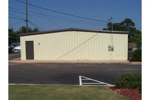
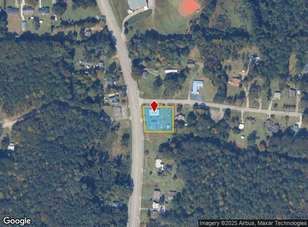
Property Record
1344 New Franklin Rd, Lagrange, GA 30240
NEARBY LISTINGS FOR SALE OR LEASE
-
-
View all Lagrange listings for sale on LoopNet.com
Property Detail
1344 New Franklin Rd
049-3B-000-021
Darden-Meadors-Ketzky
Officebuilding
1344 NEW FRANKLIN RD/ TR-1-3
X
Troup
13285C0134E
Georgia
2024
0.71 AC
2024
Troup County
960501
Columbus GA
1,040 SF
LaGrange, GA
DEMOGRAPHICS near 1344 New Franklin Rd
1 Mile
3 Mile
5 Mile
2024 Total Population
2,391
20,463
38,989
2029 Population
2,376
20,601
39,637
Pop Growth 2024-2029
(0.63%)
+ 0.67%
+ 1.66%
Average Age
39
38
39
2024 Total Households
919
8,159
15,159
HH Growth 2024-2029
(0.65%)
+ 0.71%
+ 1.68%
Median Household Inc
$54,336
$46,411
$46,639
Avg Household Size
2.50
2.40
2.50
2024 Avg HH Vehicles
2.00
2.00
2.00
Median Home Value
$269,999
$175,052
$169,716
Median Year Built
1990
1981
1982
Nearby Places
Map Layers
Map Styles
 Street
 Aerial
- Restaurants
- Banks
- Shops
- Fitness
- Groceries
Nearby Properties
Address
Land Use
TOTAL SIZE
Lot Size
Zoning
Address
Land Use
TOTAL SIZE
Lot Size
Zoning
2,095 SF
16.50 AC
16- CP-GB
Address
Land Use
TOTAL SIZE
Lot Size
Zoning
109,533 SF
1.80 AC
16- DT-MX
Address
Land Use
TOTAL SIZE
Lot Size
Zoning
174,899 SF
7.52 AC
16- TN-R
Address
Land Use
TOTAL SIZE
Lot Size
Zoning
191,357 SF
89.77 AC
01-SFMD
Address
Land Use
TOTAL SIZE
Lot Size
Zoning
2,152 SF
21.70 AC
16- CR-MR
Address
Land Use
TOTAL SIZE
Lot Size
Zoning
117,684 SF
12.61 AC
16- AC-MX
Address
Land Use
TOTAL SIZE
Lot Size
Zoning
141,328 SF
7.18 AC
16- TN-MX
Address
Land Use
TOTAL SIZE
Lot Size
Zoning
159,645 SF
2.98 AC
16- DT-MX
Address
Land Use
TOTAL SIZE
Lot Size
Zoning
3,798 SF
22.81 AC
16- CR-MR
Address
Land Use
TOTAL SIZE
Lot Size
Zoning
29,520 SF
1.92 AC
16- CP-GB
Address
Land Use
TOTAL SIZE
Lot Size
Zoning
56,620 SF
5.22 AC
16- CR-MX
Address
Land Use
TOTAL SIZE
Lot Size
Zoning
8,448 SF
25.78 AC
16- CR-MX
Address
Land Use
TOTAL SIZE
Lot Size
Zoning
3,433 SF
19.65 AC
16- CR-MR
Address
Land Use
TOTAL SIZE
Lot Size
Zoning
14,232 SF
2.59 AC
16- DT-MX
Address
Land Use
TOTAL SIZE
Lot Size
Zoning
26,150 SF
3.28 AC
16- CR-MX
Address
Land Use
TOTAL SIZE
Lot Size
Zoning
133,950 SF
1.94 AC
16- DT-MX
Address
Land Use
TOTAL SIZE
Lot Size
Zoning
92,762 SF
78.28 AC
16- SU-R
Address
Land Use
TOTAL SIZE
Lot Size
Zoning
8,424 SF
11 AC
16- CR-MR
Address
Land Use
TOTAL SIZE
Lot Size
Zoning
8,752 SF
13.43 AC
16- CR-MR
Address
Land Use
TOTAL SIZE
Lot Size
Zoning
58,322 SF
1.80 AC
16- DT-MX
Address
Land Use
TOTAL SIZE
Lot Size
Zoning
218,488 SF
32.40 AC
16- CR-MX
Address
Land Use
TOTAL SIZE
Lot Size
Zoning
125,467 SF
35.19 AC
16- CR-MX
Address
Land Use
TOTAL SIZE
Lot Size
Zoning
34,380 SF
59.74 AC
16- CR-MX
Address
Land Use
TOTAL SIZE
Lot Size
Zoning
57,494 SF
8.87 AC
16- CP-GB
Address
Land Use
TOTAL SIZE
Lot Size
Zoning
112,950 SF
15.47 AC
16- CR-MX
Address
Land Use
TOTAL SIZE
Lot Size
Zoning
150,000 SF
1.31 AC
16- DT-MX
Address
Land Use
TOTAL SIZE
Lot Size
Zoning
52,976 SF
0.29 AC
16- DT-MX
Address
Land Use
TOTAL SIZE
Lot Size
Zoning
2,000 SF
11.53 AC
16- TN-R
Address
Land Use
TOTAL SIZE
Lot Size
Zoning
16,916 SF
15.33 AC
16- SU-R
Address
Land Use
TOTAL SIZE
Lot Size
Zoning
12,620 SF
2.43 AC
16- TN-MX
The World's #1 Commercial Real Estate Marketplace
Connect with us
© 2025 CoStar Group
The information above has been obtained from sources believed reliable. While we do not doubt its accuracy we have not verified it and make no guarantee, warranty or representation about it. It is your responsibility to independently confirm its accuracy and completeness. Any projections, opinions, assumptions, or estimates used are for example only and do not represent the current or future performance of the property. The value of this transaction to you depends on tax and other factors which should be evaluated by your tax, financial, and legal advisors. You and your advisors should conduct a careful, independent investigation of the property to determine to your satisfaction the suitability of the property for your needs.