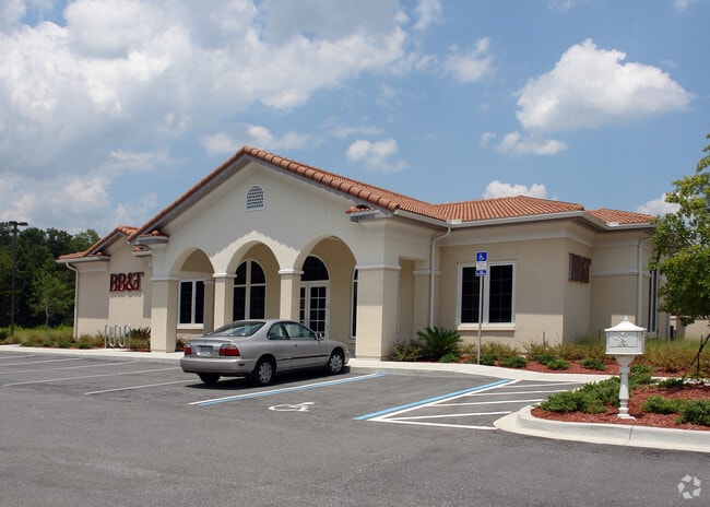
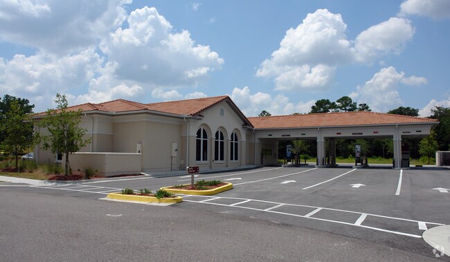
Property Record
13443 Atlantic Blvd, Jacksonville, FL 32225


NEARBY LISTINGS FOR SALE OR LEASE
Property Detail
13443 Atlantic Blvd
167141-9730
Harbour Village
Medicalbuilding
61-130 38-2S-28E 1.0 HARBOUR VILLAGE TRACT 2
X
Duval
12031C0404J
Florida
2025
1 AC
2026
Arlington
014330
Jacksonville (Florida)
5,322 SF
Jacksonville, FL
DEMOGRAPHICS near 13443 Atlantic Blvd
1 Mile
3 Mile
5 Mile
2024 Total Population
11,550
74,679
172,632
2029 Population
12,034
77,567
180,190
Pop Growth 2024-2029
+ 4.19%
+ 3.87%
+ 4.38%
Average Age
40
39
40
2024 Total Households
5,063
29,483
70,224
HH Growth 2024-2029
+ 4.31%
+ 3.99%
+ 4.56%
Median Household Inc
$74,701
$90,526
$86,134
Avg Household Size
2.30
2.50
2.40
2024 Avg HH Vehicles
2.00
2.00
2.00
Median Home Value
$344,652
$338,555
$347,394
Median Year Built
1992
1995
1991
Nearby Places
Map Layers
Map Styles
 Street
 Aerial
- Restaurants
- Banks
- Shops
- Fitness
- Groceries
PUBLIC TRANSPORTATION
AIRPORT
Jacksonville International
DRIVE
WALK
Distance
Jacksonville International
34 min
22.3 mi
Freight Ports
Jacksonville Port
DRIVE
WALK
Distance
Jacksonville Port
24 min
14.0 mi
SALE & LEASE HISTORY
LISTING DATE
SALE/LEASE

Mar 14, 2019
For Sale
Nearby Properties
Address
Land Use
TOTAL SIZE
Lot Size
Zoning
Address
Land Use
TOTAL SIZE
Lot Size
Zoning
461,453 SF
46.69 AC
PUD
Address
Land Use
TOTAL SIZE
Lot Size
Zoning
246,985 SF
14.01 AC
PUD
Address
Land Use
TOTAL SIZE
Lot Size
Zoning
377,617 SF
23.38 AC
PUD
Address
Land Use
TOTAL SIZE
Lot Size
Zoning
375,307 SF
29.13 AC
PUD
Address
Land Use
TOTAL SIZE
Lot Size
Zoning
178,884 SF
12.54 AC
PUD
Address
Land Use
TOTAL SIZE
Lot Size
Zoning
361,268 SF
15.27 AC
PUD
Address
Land Use
TOTAL SIZE
Lot Size
Zoning
194,953 SF
22.43 AC
PUD
Address
Land Use
TOTAL SIZE
Lot Size
Zoning
389,030 SF
26.39 AC
PUD
Address
Land Use
TOTAL SIZE
Lot Size
Zoning
404,896 SF
36.51 AC
PUD
Address
Land Use
TOTAL SIZE
Lot Size
Zoning
395,677 SF
45.86 AC
PUD
Address
Land Use
TOTAL SIZE
Lot Size
Zoning
277,959 SF
14.39 AC
PUD
Address
Land Use
TOTAL SIZE
Lot Size
Zoning
176,465 SF
10.33 AC
PUD
Address
Land Use
TOTAL SIZE
Lot Size
Zoning
302,329 SF
28.90 AC
PUD
Address
Land Use
TOTAL SIZE
Lot Size
Zoning
266,120 SF
14.60 AC
PUD
Address
Land Use
TOTAL SIZE
Lot Size
Zoning
328,889 SF
19.20 AC
RMD-C
Address
Land Use
TOTAL SIZE
Lot Size
Zoning
107,297 SF
6.14 AC
PUD
Address
Land Use
TOTAL SIZE
Lot Size
Zoning
206,990 SF
15.79 AC
RMD-D
Address
Land Use
TOTAL SIZE
Lot Size
Zoning
171,440 SF
11.14 AC
PUD
Address
Land Use
TOTAL SIZE
Lot Size
Zoning
206,190 SF
12.10 AC
RMD-D
Address
Land Use
TOTAL SIZE
Lot Size
Zoning
120,233 SF
14.08 AC
ACG
Address
Land Use
TOTAL SIZE
Lot Size
Zoning
183,674 SF
22.19 AC
PUD
Address
Land Use
TOTAL SIZE
Lot Size
Zoning
164,721 SF
49.91 AC
PBF-1
Address
Land Use
TOTAL SIZE
Lot Size
Zoning
135,141 SF
12.14 AC
PUD
Address
Land Use
TOTAL SIZE
Lot Size
Zoning
130,426 SF
18 AC
PUD
Address
Land Use
TOTAL SIZE
Lot Size
Zoning
284,164 SF
29.53 AC
PUD
Address
Land Use
TOTAL SIZE
Lot Size
Zoning
52,116 SF
15.05 AC
PUD
Address
Land Use
TOTAL SIZE
Lot Size
Zoning
94,836 SF
12.13 AC
PUD
Address
Land Use
TOTAL SIZE
Lot Size
Zoning
119,973 SF
8.25 AC
PUD
Address
Land Use
TOTAL SIZE
Lot Size
Zoning
145,698 SF
23.04 AC
PBF-1
Address
Land Use
TOTAL SIZE
Lot Size
Zoning
45,642 SF
6.29 AC
PUD
The World's #1 Commercial Real Estate Marketplace
Connect with us
© 2025 CoStar Group
The information above has been obtained from sources believed reliable. While we do not doubt its accuracy we have not verified it and make no guarantee, warranty or representation about it. It is your responsibility to independently confirm its accuracy and completeness. Any projections, opinions, assumptions, or estimates used are for example only and do not represent the current or future performance of the property. The value of this transaction to you depends on tax and other factors which should be evaluated by your tax, financial, and legal advisors. You and your advisors should conduct a careful, independent investigation of the property to determine to your satisfaction the suitability of the property for your needs.